1940s Maps of Charles County, Maryland
Explore 26 historic maps of Charles County from the 1940s. These maps offer a rare glimpse into what life looked like during the 1940s — showing old roads, neighborhoods, homes, and landmarks that have changed or disappeared over time.
Whether you're researching your family's past, planning a metal detecting trip, or studying how Charles County's landscape evolved across the 1940s, these high-resolution maps are a powerful tool for exploring the history of this region.
- Focus on a specific era: All maps on this page are from the 1940s, giving you a focused view of this time period.
- See what’s changed: Compare century-old streets, trails, and buildings to today's modern landscape using overlays and satellite layers.
- Research with precision: Use these maps for genealogy, historical research, land use analysis, or educational projects.
- View, download, or print: Maps are fully viewable online in high resolution, and can be downloaded or printed for your own records.
Start exploring Charles County's history through authentic maps from the 1940s. This is your window into the past.
Charles County, MD maps
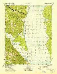
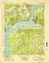
(26)- 1940 Map of Quantico
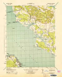
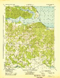
 1940 Quantico1940 Print · USGSCoastal Virginia and Maryland are captured here during the late pre-war era, showing the growing military footprint around the Potomac. Genealogists can trace family names and landmarks like Sinclairs Mill, Bacon Race School, and the historic Dumfries settlement.2 unique versions available
 - 1943 Map of Charlotte Hall
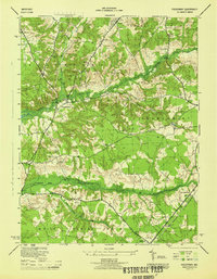
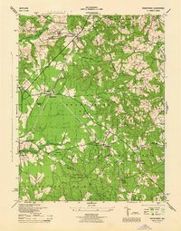
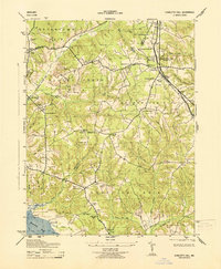 1943 Charlotte Hall1943 Print · USGSMaryland's St. Mary's and Charles counties appear here in the early 1940s, centered on the historic academic grounds at Charlotte Hall. Genealogists and local historians can trace family-named landmarks and rural hubs like Mt Calvary Ch, Ryceville, and the Budds Creek School.
 - 1943 Map of Popes Creek
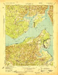
 1943 Popes Creek1943 Print · USGSSouthern Maryland during the early years of the war was a landscape of tide-water marshes and rail-linked landings. Genealogists and local historians can trace the family-named reaches of Zekiah Swamp, rural landmarks like St Marys Ch, and the rail terminus at Popes Creek.
 - 1943 Map of Rock Point
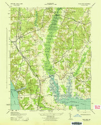
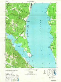
 1943 Rock Point1943 Print · USGSThe Potomac and Wicomico rivers converge here in the mid-1940s, revealing a landscape of tidewater landings and quiet parish settlements. Genealogists can trace family footprints at Sacred Heart Ch or Bushwood Wharf, and locate old schoolhouses like Abel Sch.6 unique versions available
 - 1943 Map of Stratford
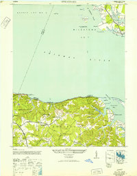
 1943 Stratford1943 Print · USGSMaryland and Virginia shorelines meet along the Potomac River in the early 1940s, highlighting the historic grounds of Stratford Hall. Genealogists and local historians can trace family-named sites like Goodrich Farm, Currioman Farm, and the riverside community of Colton.
 - 1943 Map of Quantico
 1943 Quantico1943 Print · USGSCoastal Northern Virginia in the mid-1940s reveals a region transitioning from a rural riverfront to a strategic military hub. Researchers can trace the early layout of the Marine Corps Reservation or locate family sites like Shacklet PO and Old Chopawamsic Ch.
 - 1943 Map of Morgantown
 1943 Morgantown1943 Print · USGSThe Potomac and Wicomico riverfronts come alive in this wartime survey of the Maryland-Virginia borderlands. Genealogists and local historians can trace family-named landmarks like Harris Lot and Bachelors Hope Pt or locate old community centers such as Old Christ Ch and the Tompkinsville Sch.
 - 1943 Map of Wakefield
 1943 Wakefield1943 Print · USGSCoastal Westmoreland County during the mid-forties reveals a landscape shaped by river transport and deep-rooted family settlements. Genealogists can trace rural life through landmarks like Potomac Mills, the Gravel Run School, and Monroe Hall.
 - 1944 Map of Piscataway
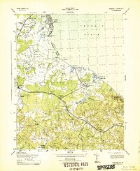
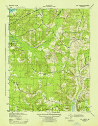
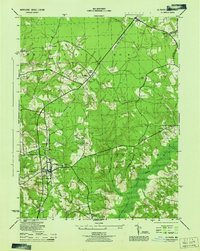
 1944 Piscataway1944 Print · USGSSouthern Maryland was a landscape of rural airfields and country parishes in the 1940s. Genealogists and historians can trace the foundations of Waldorf and Piscataway, locating local landmarks like Hyde Field Army Air Base and St Marys Church.
 - 1944 Map of Belvoir
 1944 Belvoir1944 Print · USGSFairfax County is shown at a pivotal moment in the 1940s, balancing its historic riverfront estates with wartime military expansion. Genealogists can trace old family sites and stations near Woodbridge, Colchester, and the landmark Gunston Hall.
 - 1944 Map of Widewater
 1944 Widewater1944 Print · USGSThe Potomac shoreline at the height of the Second World War shows a landscape defined by military transit and riverfront commerce. Genealogists and local historians can trace the Richmond Fredericksburg and Potomac rail stops and small hubs like Mountjoy Store and Clifton Beach.
 - 1944 Map of Port Tobacco
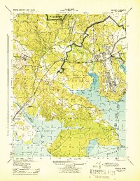
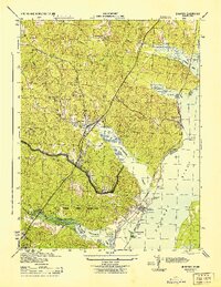
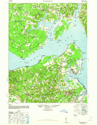
 1944 Port Tobacco1944 Print · USGSCharles County during the mid-1940s reveals a landscape of rural hamlets and emerging military infrastructure. Genealogists and local historians can trace family locations near Pomfret, the Mt Carmel Monastery, and the historic Port Tobacco PO.
 - 1944 Map of Quantico
 1944 Quantico1944 Print · USGSCoastal Prince William County is captured here at the height of the second World War, showing the expansion of military and transit infrastructure. Genealogists and historians can trace old landmarks like Little Union Ch, the Midway Island Housing Project, and the busy Quantico waterfront.2 unique versions available
 - 1944 Map of Hughesville
 1944 Hughesville1944 Print · USGSSouthern Maryland during the mid-forties remained a land of sprawling wetlands and rural crossroads at the intersection of three counties. Genealogists and historians can trace family locations near St Marys Ch, the old Burnt Store settlement, and along the U S Navy rail corridor.
 - 1944 Map of Passapatanzy
 1944 Passapatanzy1944 Print · USGSThe Virginia riverfront along the Potomac and Rappahannock appears here during the height of the Second World War. Genealogists and historians can trace family-named landmarks and rural hubs like Passapatanzy, Sealston PO, and the U. S. Government Railroad.
 - 1944 Map of Nanjemoy
 1944 Nanjemoy1944 Print · USGSMaryland and Virginia meet across the Potomac River during the 1940s, showing a region defined by naval operations and rural tidewater life. Researchers can trace military footprints at Dahlgren and Blossom Point Proving Ground or find old community centers like Nindes Store and Oak Grove Sch.
 - 1944 Map of Indian Head
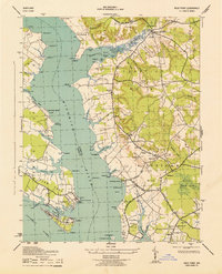
 1944 Indian Head1944 Print · USGSMaryland's riverine defense and rural character are on full display during the mid-1940s as the U. S. Naval Proving Ground expands along the Potomac River. You can trace wartime infrastructure and local heritage through landmarks like Grinders Wharf, Mason Springs Sch, and the Govt RR.
 - 1944 Map of Brandywine
 1944 Brandywine1944 Print · USGSMid-century Southern Maryland comes into focus here, showing the rural crossroads of Prince George's and Charles counties as military and institutional land use expanded. Researchers can trace family-named landmarks and local hubs like Horsehead, Cheltenham School for Boys, and St Michaels Ch.
 - 1944 Map of Mount Vernon
 1944 Mount Vernon1944 Print · USGSThe Potomac River shoreline during the Second World War reveals a landscape of coastal fortifications and early aviation. Genealogists and historians can trace old community hubs like Gum Springs, Accokeek, and the historic Marshall Hall estate.
 - 1944 Map of La Plata
 1944 La Plata1944 Print · USGSCharles County during the Second World War remains a landscape of rural crossroads and strategic outposts. Researchers can trace the Popes Creek Branch rail line or locate family sites like Sacred Heart Church, Beantown, and the La Plata Army Radio Sta.
 - 1945 Map of Brandywine
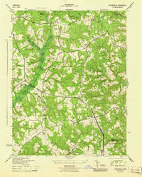
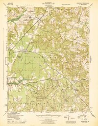 1945 Brandywine1945 Print · USGSSouthern Prince George's County at the end of the war shows a landscape of rural parishes and state-protected woodlands. Genealogists and researchers can locate family sites near Cheltenham Church, the Cedarville Sch, and the old rail line at Brandywine.
 - 1946 Map of Stratford, 1952 Print
 1946 Stratford1952 Print · USGSThe Potomac River divides Maryland and Virginia in the mid-1940s, revealing a landscape of historic plantations and river landings. Researchers can trace the grounds of Stratford Hall or locate vanished sites like Hill School and Mt Airy Wharf.
 - 1946 Map of Widewater, 1953 Print
 1946 Widewater1953 Print · USGSStafford County at the end of the war shows a river-dependent landscape where the railroad still dictated the pace of growth. Genealogists can trace family landmarks like Mountjoy Store, Fritters Corner, and the Oak Grove Ch school and church.
 - 1948 Map of Washington
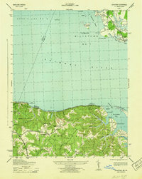
 1948 Washington1948 Print · USGSThe Potomac and Chesapeake regions in the late 1940s reveal a landscape of expanding military reach and deep-rooted Tidewater settlements. Trace old rail corridors like the Richmond Fredericksburg & Potomac RR or locate landmarks like the Wakefield Washington Monument and St. Marys College.2 unique versions available
 - 1948 Map of Nanjemoy
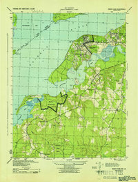
 1948 Nanjemoy1948 Print · USGSThe Potomac River tidewater region is captured here in the years following World War II, showing the rural communities of Charles County and King George County. Trace old family locales and infrastructure from Nindes Store and Grayton PO to the NAVAL PROVING GROUND.2 unique versions available
Showing maps 1-25 of 26
Top cities of Charles County
- Waldorf historical maps
- Bennsville historical maps
- La Plata historical maps
- Bryans Road historical maps
- Indian Head historical maps
- Cobb Island historical maps
See more
Frequently asked questions
- What are the different types of historical maps available for Charles County?
- What is the oldest map of Charles County?
- Where can I purchase historical maps of Charles County for my home or office?
- Where can I download high-res historical maps of Charles County?
- Are there historical topographic maps available for Charles County?
- Is there historical aerial imagery available for Charles County?
- Where are historical maps of Charles County sourced from?