1910s Maps of Garrett County, Maryland
Explore 4 historic maps of Garrett County from the 1910s. These maps offer a rare glimpse into what life looked like during the 1910s — showing old roads, neighborhoods, homes, and landmarks that have changed or disappeared over time.
Whether you're researching your family's past, planning a metal detecting trip, or studying how Garrett County's landscape evolved across the 1910s, these high-resolution maps are a powerful tool for exploring the history of this region.
- Focus on a specific era: All maps on this page are from the 1910s, giving you a focused view of this time period.
- See what’s changed: Compare century-old streets, trails, and buildings to today's modern landscape using overlays and satellite layers.
- Research with precision: Use these maps for genealogy, historical research, land use analysis, or educational projects.
- View, download, or print: Maps are fully viewable online in high resolution, and can be downloaded or printed for your own records.
Start exploring Garrett County's history through authentic maps from the 1910s. This is your window into the past.
Garrett County, MD maps
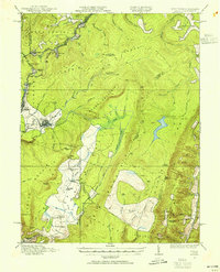
(4)- 1916 Map of Davis
 1916 Davis1916 Print · USGSHigh in the Allegheny plateau during the mid-teens, this area centers on the bustling timber and rail hubs of Thomas and Davis. Researchers can trace the path of the Lumber RR and locate rural neighborhood centers like Maple Grove School and Cortland School.2 unique versions available
 - 1918 Map of Davis
 1918 Davis1918 Print · USGSTucker County's high mountain plateaus and timber industry are at their peak during the First World War. Genealogists and historians can trace the early development of Davis and Thomas alongside rural landmarks like Maple Grove School and the Fairfax Stone.
 - 1919 Map of Elk Garden
 1919 Elk Garden1919 Print · USGSThe Potomac River corridor in the years following the Great War reveals a landscape defined by rail and ridge. Genealogists can trace family names at Rehoboth Church or locate vanished school sites like Terra Firma School and Empire School.2 unique versions available
 - 1919 Map of Davis, 1955 Print
 1919 Davis1955 Print · USGSThe West Virginia and Maryland borderlands are captured here during a peak era of timber and rail expansion. Genealogists can trace family roots through rural landmarks like the Fairfax Stone, the village of Cortland, and the Maple Grove School.2 unique versions available
End of results
Showing maps 1-4 of 4
Top cities of Garrett County
- Mountain Lake Park historical maps
- Oakland historical maps
- Grantsville historical maps
- Loch Lynn Heights historical maps
- Finzel historical maps
- Friendsville historical maps
See more
Frequently asked questions
- What are the different types of historical maps available for Garrett County?
- What is the oldest map of Garrett County?
- Where can I purchase historical maps of Garrett County for my home or office?
- Where can I download high-res historical maps of Garrett County?
- Are there historical topographic maps available for Garrett County?
- Is there historical aerial imagery available for Garrett County?
- Where are historical maps of Garrett County sourced from?