1970s Maps of Garrett County, Maryland
Explore 6 historic maps of Garrett County from the 1970s. These maps offer a rare glimpse into what life looked like during the 1970s — showing old roads, neighborhoods, homes, and landmarks that have changed or disappeared over time.
Whether you're researching your family's past, planning a metal detecting trip, or studying how Garrett County's landscape evolved across the 1970s, these high-resolution maps are a powerful tool for exploring the history of this region.
- Focus on a specific era: All maps on this page are from the 1970s, giving you a focused view of this time period.
- See what’s changed: Compare century-old streets, trails, and buildings to today's modern landscape using overlays and satellite layers.
- Research with precision: Use these maps for genealogy, historical research, land use analysis, or educational projects.
- View, download, or print: Maps are fully viewable online in high resolution, and can be downloaded or printed for your own records.
Start exploring Garrett County's history through authentic maps from the 1970s. This is your window into the past.
Garrett County, MD maps
(6)- 1977 Map of Avilton, 1979 Print
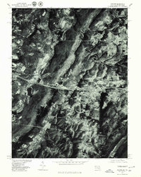 1977 Avilton1979 Print · USGSGarrett County in the late seventies is captured in this detailed aerial perspective of the ridgelines and rural settlements. Researchers can trace the exact footprint of family farms near Avilton and identify the shoreline of the Frostburg Reservoir.
 - 1977 Map of Accident, 1979 Print
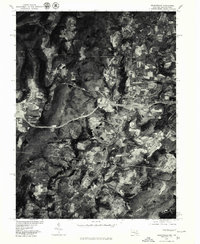
 1977 Accident1979 Print · USGSWestern Maryland's agricultural landscape is seen in detail during the late seventies through this aerial survey of Garrett County. Genealogists and local historians can trace the specific layouts of family farms and homesteads near Accident and the slopes of Rich Hill.
 - 1977 Map of Grantsville, 1979 Print
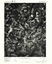
 1977 Grantsville1979 Print · USGSMaryland's high mountain country is captured during the late seventies, showing the rural landscape around the Pennsylvania border. Researchers can trace the riverbank layout of Casselman, the cross-border influence of Springs, and the forested slopes of Meadow Mountain.
 - 1977 Map of Friendsville, 1979 Print
 1977 Friendsville1979 Print · USGSThe tri-state border region of Maryland, Pennsylvania, and West Virginia is seen in the late seventies through this detailed aerial orthophoto. Researchers can trace the rural layouts of Friendsville and Markleysburg alongside the Youghiogheny River Lake.
 - 1977 Map of Frostburg, 1979 Print
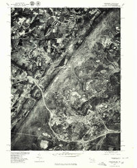 1977 Frostburg1979 Print · USGSMaryland's western highlands come into sharp focus in the late seventies, showing the mountain communities around the Frostburg State campus. Genealogists and historians can trace the road and rail patterns connecting Frostburg to Eckhart Mines and Midlothian.
 - 1979 Map of Morgantown, 1983 Print
 1979 Morgantown1983 Print · USGSThe northern Appalachian borderlands are captured here in the late seventies, showing the tri-state area of West Virginia, Pennsylvania, and Maryland. Genealogists and historians can trace the Mason and Dixon Line through mountain settlements like Markleysburg and across the Youghiogheny River Lake.
End of results
Showing maps 1-6 of 6
Top cities of Garrett County
- Mountain Lake Park historical maps
- Oakland historical maps
- Grantsville historical maps
- Loch Lynn Heights historical maps
- Finzel historical maps
- Friendsville historical maps
See more
Frequently asked questions
- What are the different types of historical maps available for Garrett County?
- What is the oldest map of Garrett County?
- Where can I purchase historical maps of Garrett County for my home or office?
- Where can I download high-res historical maps of Garrett County?
- Are there historical topographic maps available for Garrett County?
- Is there historical aerial imagery available for Garrett County?
- Where are historical maps of Garrett County sourced from?