1950s Maps of Harford County, Maryland
Explore 17 historic maps of Harford County from the 1950s. These maps offer a rare glimpse into what life looked like during the 1950s — showing old roads, neighborhoods, homes, and landmarks that have changed or disappeared over time.
Whether you're researching your family's past, planning a metal detecting trip, or studying how Harford County's landscape evolved across the 1950s, these high-resolution maps are a powerful tool for exploring the history of this region.
- Focus on a specific era: All maps on this page are from the 1950s, giving you a focused view of this time period.
- See what’s changed: Compare century-old streets, trails, and buildings to today's modern landscape using overlays and satellite layers.
- Research with precision: Use these maps for genealogy, historical research, land use analysis, or educational projects.
- View, download, or print: Maps are fully viewable online in high resolution, and can be downloaded or printed for your own records.
Start exploring Harford County's history through authentic maps from the 1950s. This is your window into the past.
Harford County, MD maps
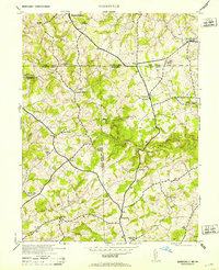
(17)- 1951 Map of Betterton
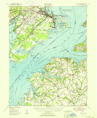 1951 Betterton1951 Print · USGSUpper Chesapeake Bay communities and military installations are captured here just after the war, showing the expansion of the Aberdeen Proving Grounds. Researchers can trace rural life and coastal trade through sites like the Still Pond Sta, Harris Wharf, and the Harford Furnace School.2 unique versions available
 - 1951 Map of White Marsh
 1951 White Marsh1951 Print · USGSThe Baltimore and Harford county line comes alive in the early fifties as rural hamlets give way to a growing transit corridor. Genealogists and historians can trace family roots through landmarks like Union Chapel Church, Long Green Station, and the old mill site at Franklinville.6 unique versions available
 - 1951 Map of Gunpowder Neck
 1951 Gunpowder Neck1951 Print · USGSThe Harford County shoreline and the Gunpowder Neck are captured here in the mid-century as a mix of military expansion and bayfront leisure. Genealogists and historians can trace rail stops like Chase Station, the development of Harewood Park, and the isolated lighthouse at Pooles Island.2 unique versions available
 - 1951 Map of Edgewood
 1951 Edgewood1951 Print · USGSHarford County's coastal corridor is shown here during the post-war expansion of the military and rail networks. Researchers can trace the development of the Army Chemical Center alongside older landmarks like the McComas Institute, Harford Furnace, and St Mary's Church.2 unique versions available
 - 1953 Map of Norrisville
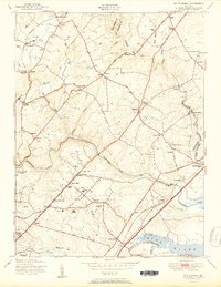
 1953 Norrisville1953 Print · USGSThe Maryland-Pennsylvania border comes alive in this mid-century portrait of the Mason and Dixon Line and its surrounding farming communities. Genealogists and historians can trace the foundations of Norrisville and locate Ebaughs School or Amos Mill.2 unique versions available
 - 1953 Map of Conowingo Dam, 1954 Print
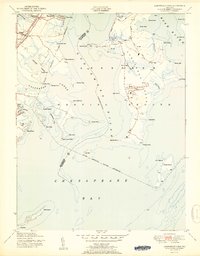
 1953 Conowingo Dam1954 Print · USGSThe Cecil and Harford County borderlands are caught in a period of industrial transition during the 1950s. Genealogists and researchers can trace family landmarks like Darlington Cem, old schools at New Valley Sch, and the rail lines serving Conowingo Sta.6 unique versions available
 - 1953 Map of Aberdeen, 1955 Print
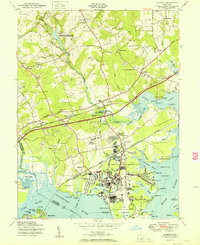
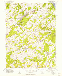
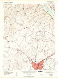 1953 Aberdeen1955 Print · USGSHarford County is documented here in the early fifties, showing the growth of Aberdeen as a major rail hub near the Susquehanna River. Genealogists and historians can trace family-named sites like Noble Mill, St James Ch, and the grounds of Halls Crossroads Sch.5 unique versions available
 - 1953 Map of Havre De Grace, 1955 Print
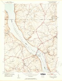
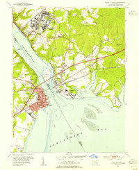 1953 Havre De Grace1955 Print · USGSMid-century Cecil County and the Susquehanna mouth are defined here by major military and rail infrastructure. Genealogists can locate family sites at Cokesbury Ch Cem or St Marks Ch Cem and trace the development of Perryville and Bainbridge.8 unique versions available
 - 1954 Map of Baltimore
 1954 Baltimore1954 Print · USGSThe Mid-Atlantic region in the early fifties shows a landscape of growing suburban centers and heavy rail corridors. Trace mid-century transit networks and military landmarks from the Aberdeen Proving Ground to the Gettysburg National Military Park.
 - 1956 Map of Baltimore
 1956 Baltimore1956 Print · USGSMid-century Maryland and Pennsylvania are captured here during a period of massive suburban and military growth across the Chesapeake region. Genealogists and historians can trace the rail corridors of the Baltimore & Ohio RR and locate landmarks like Fort McHenry or the Aberdeen Proving Ground.
 - 1956 Map of Bel Air, 1957 Print
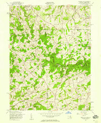
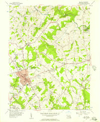 1956 Bel Air1957 Print · USGSHarford County's heart is captured here in the mid-fifties, showing the growth of Bel Air and its surrounding countryside. Researchers can trace family sites from Moores Mill to Churchville, locating numerous landmarks like St Ignatius Ch and Asbury Cem.4 unique versions available
 - 1956 Map of Fawn Grove, 1957 Print
 1956 Fawn Grove1957 Print · USGSThe Pennsylvania and Maryland borderlands are captured here in the mid-fifties, showing a landscape of small farming settlements and winding creek valleys. Genealogists and local historians can trace family locations near Fawn Grove, St Pauls Ch, and the rural community of Constitution.3 unique versions available
 - 1956 Map of Jarrettsville, 1957 Print
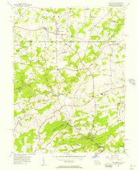
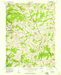
 1956 Jarrettsville1957 Print · USGSHarford County's rural character is well-preserved here in the mid-1950s, showing the settlement patterns of the Maryland piedmont. Researchers can trace family history through sites like Old Brick Ch, Youths Benefit School, and the Pennsylvania rail line.4 unique versions available
 - 1956 Map of Delta, 1957 Print
 1956 Delta1957 Print · USGSThe Pennsylvania-Maryland border country comes alive in the mid-1950s, centered on the slate-quarrying hubs of Delta and Cardiff. Genealogists and rail historians can trace the Maryland and Pennsylvania Railroad past Slate Ridge School and Mt Zion Cem.4 unique versions available
 - 1957 Map of Norrisville, 1958 Print
 1957 Norrisville1958 Print · USGSThe Mason-Dixon line divides this rural landscape in the 1950s, where Harford and York counties meet. Genealogists and historians can trace the Baltimore and Pennsylvania RR and locate old landmarks like Gorsuch Mills, Ivory Mill, and Ayers Chapel.4 unique versions available
 - 1957 Map of Phoenix, 1958 Print
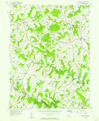
 1957 Phoenix1958 Print · USGSThe northern Maryland countryside at the end of the fifties reveals a landscape of historic manors and emerging suburban hamlets. Researchers can trace the Pennsylvania Railroad corridor and locate landmarks like the Elkridge-Harford Hunt Club, Houcks Mill, and My Ladys Manor.4 unique versions available
 - 1957 Map of Baltimore, 1964 Print
 1957 Baltimore1964 Print · USGSMaryland and Southern Pennsylvania are shown during the mid-century expansion of the Baltimore-Washington corridor. Researchers can trace the extensive rail lines of the Baltimore & Ohio RR and locate sites like Fort Detrick and Gettysburg National Military Park.5 unique versions available
End of results
Showing maps 1-17 of 17
Top cities of Harford County
- Edgewood historical maps
- Forest Hill historical maps
- Aberdeen historical maps
- Havre de Grace historical maps
- Bel Air historical maps
- Fallston historical maps
See more
Frequently asked questions
- What are the different types of historical maps available for Harford County?
- What is the oldest map of Harford County?
- Where can I purchase historical maps of Harford County for my home or office?
- Where can I download high-res historical maps of Harford County?
- Are there historical topographic maps available for Harford County?
- Is there historical aerial imagery available for Harford County?
- Where are historical maps of Harford County sourced from?