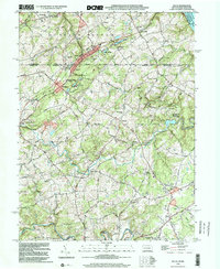
1990s Maps of Harford County, Maryland
Explore 7 historic maps of Harford County from the 1990s. These maps offer a rare glimpse into what life looked like during the 1990s — showing old roads, neighborhoods, homes, and landmarks that have changed or disappeared over time.
Whether you're researching your family's past, planning a metal detecting trip, or studying how Harford County's landscape evolved across the 1990s, these high-resolution maps are a powerful tool for exploring the history of this region.
- Focus on a specific era: All maps on this page are from the 1990s, giving you a focused view of this time period.
- See what’s changed: Compare century-old streets, trails, and buildings to today's modern landscape using overlays and satellite layers.
- Research with precision: Use these maps for genealogy, historical research, land use analysis, or educational projects.
- View, download, or print: Maps are fully viewable online in high resolution, and can be downloaded or printed for your own records.
Start exploring Harford County's history through authentic maps from the 1990s. This is your window into the past.
Harford County, MD maps
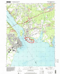
(7)- 1992 Map of Havre De Grace, 1993 Print
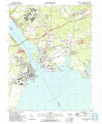 1992 Havre De Grace1993 Print · USGSThe northern reaches of the Chesapeake Bay are frozen in time in the early nineties, documenting the critical river crossings at Havre De Grace and Perryville. Researchers can trace the legacy of the Principio Furnace, locate the Concord Pt Lighthouse, and find family history at Mt Erin Cem or Patterson Cem.
 - 1992 Map of Conowingo Dam, 1995 Print
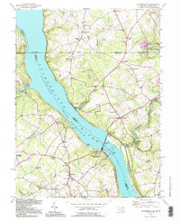 1992 Conowingo Dam1995 Print · USGSThe Susquehanna River valley at the Maryland-Pennsylvania border is shown here during the late twentieth century, centered on the Conowingo Dam. Genealogists and historians can trace family locations near St Patricks Ch, the Mason and Dixon Line, and the old settlement of Rowlandsville.
 - 1992 Map of Fawn Grove, 1995 Print
 1992 Fawn Grove1995 Print · USGSThe Pennsylvania-Maryland border country comes to life in the 1990s, showcasing the rural landscapes of York and Harford Counties. Genealogists and historians can trace family locations near Fawn Grove Cem, the old Pennsylvania Railroad line, and the landmarks of Rocks State Park.
 - 1995 Map of Conowingo Dam, 1999 Print
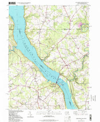 1995 Conowingo Dam1999 Print · USGSThe Susquehanna River borderlands in the late twentieth century highlight the massive Conowingo Dam and the historical Mason and Dixon Line. Genealogists and local historians can trace family locations near Darlington, Rowlandsville, and Harmony Chapel.
 - 1995 Map of Gunpowder Neck, 1999 Print
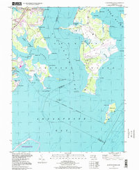 1995 Gunpowder Neck1999 Print · USGSCoastal Harford County and the upper Chesapeake Bay are captured here in the mid-nineties, showing the expansive military and park lands at the river mouths. Trace the rail lines through Chase Station or locate the historic tower and lighthouse on Pooles Island.
 - 1998 Map of Havre De Grace, 2000 Print
 1998 Havre De Grace2000 Print · USGSThe Susquehanna meets the Chesapeake in this late-century study of a vital Maryland junction. Researchers can trace the legacy of the Perry Point VA Medical Center, locate Principio Furnace, and find family names at Patterson Cem or Mt Erin Cem.
 - 1999 Map of Delta, 2001 Print
 1999 Delta2001 Print · USGSThe Pennsylvania-Maryland border country at the end of the century reveals a landscape shaped by stone extraction and rural commerce. Researchers can trace the industrial legacy of Funkhouser Quarry, the Old Railroad Grade, and local landmarks like the Fire Observation Station No 77.
End of results
Showing maps 1-7 of 7
Top cities of Harford County
- Edgewood historical maps
- Forest Hill historical maps
- Aberdeen historical maps
- Havre de Grace historical maps
- Bel Air historical maps
- Fallston historical maps
See more
Frequently asked questions
- What are the different types of historical maps available for Harford County?
- What is the oldest map of Harford County?
- Where can I purchase historical maps of Harford County for my home or office?
- Where can I download high-res historical maps of Harford County?
- Are there historical topographic maps available for Harford County?
- Is there historical aerial imagery available for Harford County?
- Where are historical maps of Harford County sourced from?