1970s Maps of Montgomery County, Maryland
Explore 3 historic maps of Montgomery County from the 1970s. These maps offer a rare glimpse into what life looked like during the 1970s — showing old roads, neighborhoods, homes, and landmarks that have changed or disappeared over time.
Whether you're researching your family's past, planning a metal detecting trip, or studying how Montgomery County's landscape evolved across the 1970s, these high-resolution maps are a powerful tool for exploring the history of this region.
- Focus on a specific era: All maps on this page are from the 1970s, giving you a focused view of this time period.
- See what’s changed: Compare century-old streets, trails, and buildings to today's modern landscape using overlays and satellite layers.
- Research with precision: Use these maps for genealogy, historical research, land use analysis, or educational projects.
- View, download, or print: Maps are fully viewable online in high resolution, and can be downloaded or printed for your own records.
Start exploring Montgomery County's history through authentic maps from the 1970s. This is your window into the past.
Montgomery County, MD maps
(3)- 1970 Map of Waterford, 1971 Print
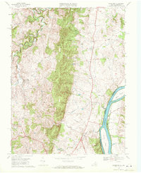 1970 Waterford1971 Print · USGSLoudoun County’s rural landscape is captured here in the early seventies, featuring the prominent ridge of Catoctin Mountain and the winding Potomac River. Genealogists and local historians can locate long-standing landmarks like Union Cemetery, Faith Chapel, and the historic settlement of Waterford.4 unique versions available
 - 1970 Map of Poolesville, 1972 Print
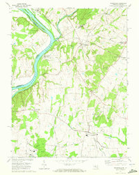 1970 Poolesville1972 Print · USGSUpper Montgomery County and the Potomac River shoreline are detailed here in the 1970s, showcasing a landscape of historic canal engineering and rural crossroads. You can trace the Chesapeake and Ohio Canal to the Monocacy Aqueduct or find local landmarks like Elijah Ch and Mt Pleasant Cem.2 unique versions available
 - 1973 Map of Vienna, 1980 Print
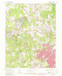 1973 Vienna1980 Print · USGSNorthern Virginia undergoes a dramatic transformation into a suburban hub during the late seventies. Researchers can trace the development of Reston and Vienna alongside historic landmarks like Colvin Run Mill and the Wolf Trap Farm Park.
End of results
Showing maps 1-3 of 3
Top cities of Montgomery County
- Germantown historical maps
- Silver Spring historical maps
- Gaithersburg historical maps
- Bethesda historical maps
- Rockville historical maps
- Wheaton historical maps
See more
Frequently asked questions
- What are the different types of historical maps available for Montgomery County?
- What is the oldest map of Montgomery County?
- Where can I purchase historical maps of Montgomery County for my home or office?
- Where can I download high-res historical maps of Montgomery County?
- Are there historical topographic maps available for Montgomery County?
- Is there historical aerial imagery available for Montgomery County?
- Where are historical maps of Montgomery County sourced from?