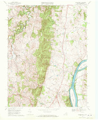
1970 Map of Waterford
USGS Topo · Published 1971About this map
Catoctin Mountain bisects this landscape, creating a distinct physical barrier between the agricultural valley of Waterford and the Potomac River corridor. In the early 1970s, the village of Waterford remains a central hub of local history, its cluster of structures surrounded by the winding waters of Catoctin Creek. To the east, the rural settlement of Lucketts serves as a crossroads near the Maryland border, where the Chesapeake and Ohio Canal traces the riverbank opposite Mason Island. Local-history researchers can find established landmarks such as Union Cemetery and Faith Chapel, while the presence of a Landing Strip and Radio Tower indicates the mid-century infrastructure beginning to dot the Loudoun County countryside. The map also captures the topography around Paeonian Springs and Clarks Gap, documenting the early road networks including Whites Ferry Road before significant modern suburban expansion.
Find a feature on this map
30 named features on this map. Tap any name to fly to it.
Don’t see what you’re looking for? This feature index may not catch every label — zoom into the map to look around manually.
Map Details
Editions of this 1970 Waterford Map
4 editions found
Other maps of this area

1884 · Harpers Ferry
USGS Topo · 1:125,000

1891 · Harpers Ferry
USGS Topo · 1:125,000

1893 · Frederick
USGS Topo · 1:125,000

1893 · Harpers Ferry
USGS Topo · 1:125,000

1894 · Frederick
USGS Topo · 1:125,000

1908 · Middletown
USGS Topo · 1:48,000

1908 · Seneca
USGS Topo · 1:62,500

1908 · Ijamsville
USGS Topo · 1:62,500

1909 · Ijamsville
USGS Topo · 1:62,500

1910 · Antietam
USGS Topo · 1:62,500