1980s Maps of Lexington Park, Maryland
Explore 4 historic maps of Lexington Park from the 1980s. These maps offer a rare glimpse into what life looked like during the 1980s — showing old roads, neighborhoods, homes, and landmarks that have changed or disappeared over time.
Whether you're researching your family's past, planning a metal detecting trip, or studying how Lexington Park's landscape evolved across the 1980s, these high-resolution maps are a powerful tool for exploring the history of this region.
- Focus on a specific era: All maps on this page are from the 1980s, giving you a focused view of this time period.
- See what’s changed: Compare century-old streets, trails, and buildings to today's modern landscape using overlays and satellite layers.
- Research with precision: Use these maps for genealogy, historical research, land use analysis, or educational projects.
- View, download, or print: Maps are fully viewable online in high resolution, and can be downloaded or printed for your own records.
Start exploring Lexington Park's history through authentic maps from the 1980s. This is your window into the past.
Lexington Park, MD maps
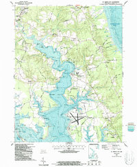
(4)- 1983 Map of Leonardtown, 1984 Print
 1983 Leonardtown1984 Print · USGSSouthern Maryland and the Northern Neck of Virginia are shown in the early eighties as a mosaic of historic tidewater settlements and modern installations. Trace family roots and shoreline changes near St Marys City, Leonardtown, and Colonial Beach.2 unique versions available
 - 1987 Map of St. Marys City
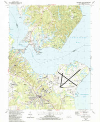
 1987 St. Marys City1987 Print · USGSMaryland's tidewater heritage is on full display in the 1980s, from the historic capital at St Marys City to the military installation at Webster Field. Genealogists and historians can trace old community hubs like St Inigoes Ch and landings such as Calloway Landing.2 unique versions available
 - 1987 Map of Solomons Island
 1987 Solomons Island1987 Print · USGSThe Patuxent River meets the Chesapeake Bay in the late eighties, showing a landscape shaped by military aviation and maritime life. Researchers can find coastal details from the Naval Air Test Center to local landmarks like Immaculate Heart of Mary Ch and Solomons.
 - 1989 Map of Washington
 1989 Washington1989 Print · USGSThe Potomac River valley and Chesapeake Bay are shown in comprehensive detail during the late 1980s. Genealogists and historians can trace the transition from urban Alexandria to the rural Northern Neck, locating landmarks like Mount Vernon and Stratford Hall.
End of results
Showing maps 1-4 of 4
Top cities near Lexington Park
- California historical maps
- Chesapeake Ranch Estates historical maps
- Wildewood historical maps
- Golden Beach historical maps
- Solomons historical maps
- Drum Point historical maps
See more
Top neighborhoods of Lexington Park
- Town Creek historical maps
- Spencers Wharf historical maps
- Great Mills historical maps
- North Town Creek Manor historical maps
- California historical maps
- Wildewood historical maps
See more
Frequently asked questions
- What are the different types of historical maps available for Lexington Park?
- What is the oldest map of Lexington Park?
- Where can I purchase historical maps of Lexington Park for my home or office?
- Where can I download high-res historical maps of Lexington Park?
- Are there historical topographic maps available for Lexington Park?
- Is there historical aerial imagery available for Lexington Park?
- Where are historical maps of Lexington Park sourced from?