1940s Maps of Lexington Park, Maryland
Explore 5 historic maps of Lexington Park from the 1940s. These maps offer a rare glimpse into what life looked like during the 1940s — showing old roads, neighborhoods, homes, and landmarks that have changed or disappeared over time.
Whether you're researching your family's past, planning a metal detecting trip, or studying how Lexington Park's landscape evolved across the 1940s, these high-resolution maps are a powerful tool for exploring the history of this region.
- Focus on a specific era: All maps on this page are from the 1940s, giving you a focused view of this time period.
- See what’s changed: Compare century-old streets, trails, and buildings to today's modern landscape using overlays and satellite layers.
- Research with precision: Use these maps for genealogy, historical research, land use analysis, or educational projects.
- View, download, or print: Maps are fully viewable online in high resolution, and can be downloaded or printed for your own records.
Start exploring Lexington Park's history through authentic maps from the 1940s. This is your window into the past.
Lexington Park, MD maps
(5)- 1942 Map of Drum Point
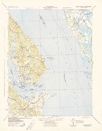 1942 Drum Point1942 Print · USGSThe Chesapeake Bay shoreline in the early 1940s reveals a world of maritime activity and isolated coastal communities. Genealogists and local historians can trace the foundations of Solomons, locate Spencers Wharf, and explore the marshes of Taylors Island.
 - 1943 Map of St. Marys City
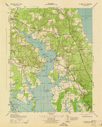 1943 St. Marys City1943 Print · USGSCoastal St. Mary's County is shown here during the early 1940s, when the river and bay still dictated the pace of life. Genealogists can trace old family sites and crossroads from Great Mills to St Inigoes, or locate historic landings like Broommes Wharf and Grason Ldg.4 unique versions available
 - 1943 Map of Piney Point
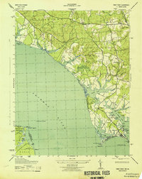 1943 Piney Point1943 Print · USGSCoastal St. Mary's County is captured mid-century as maritime tradition meets wartime expansion along the Potomac River. Researchers can locate family landmarks like Valley Lee, the Piney Point Lighthouse, and the Emergency Landing Field.
 - 1944 Map of Solomons Island
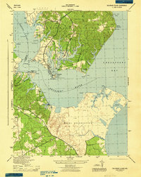 1944 Solomons Island1944 Print · USGSCoastal Maryland at the mouth of the Patuxent River is captured here in the mid-1940s, highlighting the expansion of the Naval Reservation. Genealogists and local historians can locate early communities like Johnstown, Jarboesville, and the Pearson Po settlement.4 unique versions available
 - 1948 Map of Washington
 1948 Washington1948 Print · USGSThe Potomac and Chesapeake regions in the late 1940s reveal a landscape of expanding military reach and deep-rooted Tidewater settlements. Trace old rail corridors like the Richmond Fredericksburg & Potomac RR or locate landmarks like the Wakefield Washington Monument and St. Marys College.2 unique versions available
End of results
Showing maps 1-5 of 5
Top cities near Lexington Park
- California historical maps
- Chesapeake Ranch Estates historical maps
- Wildewood historical maps
- Golden Beach historical maps
- Solomons historical maps
- Drum Point historical maps
See more
Top neighborhoods of Lexington Park
- Town Creek historical maps
- Spencers Wharf historical maps
- Great Mills historical maps
- North Town Creek Manor historical maps
- California historical maps
- Wildewood historical maps
See more
Frequently asked questions
- What are the different types of historical maps available for Lexington Park?
- What is the oldest map of Lexington Park?
- Where can I purchase historical maps of Lexington Park for my home or office?
- Where can I download high-res historical maps of Lexington Park?
- Are there historical topographic maps available for Lexington Park?
- Is there historical aerial imagery available for Lexington Park?
- Where are historical maps of Lexington Park sourced from?