1960s Maps of Somerset County, Maryland
Explore 13 historic maps of Somerset County from the 1960s. These maps offer a rare glimpse into what life looked like during the 1960s — showing old roads, neighborhoods, homes, and landmarks that have changed or disappeared over time.
Whether you're researching your family's past, planning a metal detecting trip, or studying how Somerset County's landscape evolved across the 1960s, these high-resolution maps are a powerful tool for exploring the history of this region.
- Focus on a specific era: All maps on this page are from the 1960s, giving you a focused view of this time period.
- See what’s changed: Compare century-old streets, trails, and buildings to today's modern landscape using overlays and satellite layers.
- Research with precision: Use these maps for genealogy, historical research, land use analysis, or educational projects.
- View, download, or print: Maps are fully viewable online in high resolution, and can be downloaded or printed for your own records.
Start exploring Somerset County's history through authentic maps from the 1960s. This is your window into the past.
Somerset County, MD maps
(13)- 1961 Map of Eastville
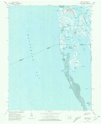
 1961 Eastville1961 Print · USGSThe Eastern Shore and Outer Banks are captured here in the mid-twentieth century, showing a maritime landscape of lighthouses, rail-linked towns, and naval outposts. Researchers can trace the Pennsylvania Railroad through Parksley or locate historical sites like Chincoteague Field Naval Auxiliary Air Station and Tangier Island.
 - 1961 Map of Washington
 1961 Washington1961 Print · USGSThe mid-Atlantic region in the late fifties is presented in remarkable detail, from the Blue Ridge foothills to the Chesapeake Eastern Shore. Researchers can trace historic river landings and military sites like Mount Vernon, Fort Belvoir, and Point Lookout.2 unique versions available
 - 1961 Map of Salisbury
 1961 Salisbury1961 Print · USGSThe Delmarva Peninsula comes into focus in the early sixties, showing the vital road and rail networks connecting the Chesapeake to the Atlantic. Genealogists and historians can trace family-named landings and coastal landmarks from Crisfield to the Brandywine Shoal Lighthouse.
 - 1964 Map of Richmond
 1964 Richmond1964 Print · USGSCoastal and central Virginia are mapped during the mid-twentieth century, showing the critical intersection of rail, river, and military life. Genealogists can trace family roots through rural county seats like Amelia or find vanished coastal neighborhoods near Phoebus and Hilton Village.
 - 1965 Map of Salisbury
 1965 Salisbury1965 Print · USGSThe Delmarva Peninsula in the mid-1960s is depicted here as a landscape of coastal defenses and maritime hubs. Genealogists and local historians can trace the foundations of bayside towns like Crisfield and the tactical positioning of the Fort Miles Military Reservation and Cape May Naval Air Station.
 - 1966 Map of Eastville
 1966 Eastville1966 Print · USGSThe Delmarva Peninsula and Outer Banks appear in the mid-sixties, showing a landscape of maritime trade, military outposts, and fishing villages. Researchers can trace the lines of the Norfolk & Southern through Exmore and Parksley or locate historical sites like Fort John Custis and the Janes Island Lighthouse.
 - 1968 Map of Great Fox Island, 1971 Print
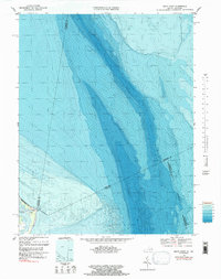
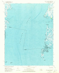 1968 Great Fox Island1971 Print · USGSChesapeake Bay watermen navigated this intricate network of sounds and marshes in the late sixties. Genealogists and historians can trace the remote outposts of Smith Island, the marshes of Janes Island, and family landmarks like Horse Hammock.3 unique versions available
 - 1968 Map of Hallwood, 1971 Print
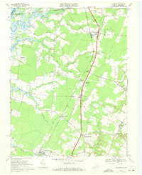 1968 Hallwood1971 Print · USGSIn the late 1960s, the rural corridor of the Virginia Eastern Shore was a landscape of rail-linked hamlets and tidal creeks. Researchers can trace the heritage of local families through landmarks like Jerusalem Ch, Greenwood Cem, and the historic crossing at Jenkins Bridge.4 unique versions available
 - 1968 Map of Saxis, 1972 Print
 1968 Saxis1972 Print · USGSThe Virginia-Maryland borderlands of the late sixties are captured here, showing the delicate balance of life along Pocomoke Sound. Genealogists and local historians can trace family-named sites like Pitts Neck or visit coastal settlements such as Saxis and Sanford.3 unique versions available
 - 1968 Map of Crisfield, 1972 Print
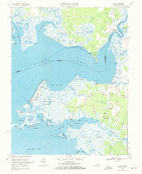
 1968 Crisfield1972 Print · USGSCoastal Somerset County comes alive in this late-sixties survey of the area's intricate marshlands and seafood-processing centers. Genealogists and local historians can trace family-named settlements like Sackertown, Byrdtown, and Mariners or locate local institutions like Phoenix Ch.5 unique versions available
 - 1968 Map of Ewell, 1972 Print
 1968 Ewell1972 Print · USGSSmith Island remains a secluded maritime world in the late sixties, where life revolves around the guts and ditches of the Chesapeake. Genealogists and historians can trace the foundations of Ewell, Rhodes Point, and Tylerton, along with landmarks like Calvary Ch.2 unique versions available
 - 1968 Map of Pocomoke City, 1972 Print
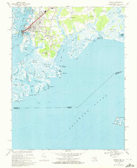
 1968 Pocomoke City1972 Print · USGSMaryland's Lower Eastern Shore and the Virginia borderlands are captured here in the late sixties, centered on the riverfront commerce of Pocomoke City. Genealogists and local historians can trace rural family sites like Puncheon Landing, Costen, and Cedar Hall, alongside country landmarks such as Tindlys Chapel.2 unique versions available
 - 1968 Map of Smith Point, 1984 Print
 1968 Smith Point1984 Print · USGSThe mouth of the Potomac River meets the Chesapeake Bay in the late sixties, where nautical landmarks and submerged topography define the maritime boundary. Trace the coastal edge at Smith Pt, locate the Light marking the channel, and see the nearby Bamboo Island.2 unique versions available
End of results
Showing maps 1-13 of 13
Top cities of Somerset County
Frequently asked questions
- What are the different types of historical maps available for Somerset County?
- What is the oldest map of Somerset County?
- Where can I purchase historical maps of Somerset County for my home or office?
- Where can I download high-res historical maps of Somerset County?
- Are there historical topographic maps available for Somerset County?
- Is there historical aerial imagery available for Somerset County?
- Where are historical maps of Somerset County sourced from?