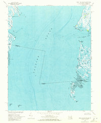
1968 Map of Great Fox Island
USGS Topo · Published 1971About this map
Tangier Sound dominates this coastal survey, where the maritime boundary between Maryland and Virginia intersects a landscape of shifting salt marshes and tidal channels. The shoreline of Janes Island State Park and the nearby town of Crisfield define the eastern edge, while the eastern fringes of Smith Island appear across the sound to the west. This area is characterized by a complex network of waterways like the Little Annemessex River and Big Thorofare, which historically served as the primary thoroughfares for the region’s watermen.
Find a feature on this map
46 named features on this map. Tap any name to fly to it.
Don’t see what you’re looking for? This feature index may not catch every label — zoom into the map to look around manually.
Map Details
Editions of this 1968 Great Fox Island Map
3 editions found
Other maps of this area

1898 · St. Marys
USGS Topo · 1:125,000

1903 · Crisfield
USGS Topo · 1:62,500

1903 · Bloodsworth Island
USGS Topo · 1:62,500

1903 · Deal Island
USGS Topo · 1:62,500

1906 · St. Marys
USGS Topo · 1:125,000

1917 · Ewell
USGS Topo · 1:62,500

1920 · Crisfield
USGS Topo · 1:62,500

1942 · Chesconessex
USGS Topo · 1:31,680

1942 · Terrapin Sand Point
USGS Topo · 1:24,000

1942 · Kedges Straits
USGS Topo · 1:24,000