1990s Maps of Berkshire County, Massachusetts
Explore 21 historic maps of Berkshire County from the 1990s. These maps offer a rare glimpse into what life looked like during the 1990s — showing old roads, neighborhoods, homes, and landmarks that have changed or disappeared over time.
Whether you're researching your family's past, planning a metal detecting trip, or studying how Berkshire County's landscape evolved across the 1990s, these high-resolution maps are a powerful tool for exploring the history of this region.
- Focus on a specific era: All maps on this page are from the 1990s, giving you a focused view of this time period.
- See what’s changed: Compare century-old streets, trails, and buildings to today's modern landscape using overlays and satellite layers.
- Research with precision: Use these maps for genealogy, historical research, land use analysis, or educational projects.
- View, download, or print: Maps are fully viewable online in high resolution, and can be downloaded or printed for your own records.
Start exploring Berkshire County's history through authentic maps from the 1990s. This is your window into the past.
Berkshire County, MA maps
(21)- 1990 Map of Ashfield
 1990 Ashfield1990 Print · USGSFranklin County's high country is captured here in the late twentieth century, showing a landscape of small hill towns and protected forests. Researchers can trace family sites at Pudding Hollow Cem or explore early settlements like Plainfield and South Hawley.2 unique versions available
 - 1990 Map of Rowe
 1990 Rowe1990 Print · USGSThe Deerfield River valley of northern Franklin County comes into focus in the 1980s, balancing industrial sites with large tracts of state forest. Genealogists and local historians can locate several family cemeteries, the Davis Mine, and the iconic Hoosac Tunnel.2 unique versions available
 - 1990 Map of Goshen
 1990 Goshen1990 Print · USGSHampshire County in the early nineties remains a landscape of deep river valleys and high forest ridges. Genealogists and historians can locate rural landmarks like Goshen Cem, the Cummington Fairgrounds, and the Davenport Sch.
 - 1997 Map of East Lee, 1999 Print
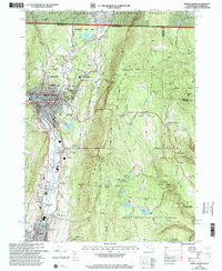
 1997 East Lee1999 Print · USGSThe Berkshires in the late twentieth century remain a sanctuary of state forests and mountain trails. Genealogists and hikers can trace the Appalachian Trail past Washington Cem or locate the famed Jacob's Pillow School and Theatre.
 - 1997 Map of Great Barrington, 1999 Print
 1997 Great Barrington1999 Print · USGSThe Berkshires in the late 1990s show a refined balance of historic village life and extensive mountain conservation. Researchers can trace the Appalachian Trail over East Mtn or locate regional landmarks like Simons Rock Bard College and Lake Buel.
 - 1997 Map of Otis, 1999 Print
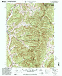
 1997 Otis1999 Print · USGSBerkshire County at the close of the twentieth century remains a landscape of deep forests and quiet hill towns. Researchers can trace the Appalachian Trail through Beartown State Forest or locate local landmarks like the Old Center Cem and Our Lady of the Hills Chapel.
 - 1997 Map of Goshen, 1999 Print
 1997 Goshen1999 Print · USGSThe hill towns of Hampshire County come into focus in the late 1990s, where protected state forests meet historic valley settlements along the Westfield River. Genealogists and historians can locate the Cummington Fairgrounds, Lithia Chapel, and several family-named burial sites like Dawes Cem.
 - 1997 Map of Pittsfield East, 1999 Print
 1997 Pittsfield East1999 Print · USGSThe eastern Berkshires come into focus in the late nineties, showcasing the intersection of the industrial Housatonic valley and the highland forests. Genealogists can locate family sites at Ashuelot Cem or New Lenox Cem, while hikers can trace the Appalachian Trail over Tully Mtn.
 - 1997 Map of Tolland Center, 1999 Print
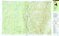
 1997 Tolland Center1999 Print · USGSThe Berkshires and Litchfield Hills meet here in the late nineties, where massive state forests border the Farmington River valley. Genealogists and hikers can locate the Sandisfield Cem, Rollhouse School, and several camps along the shores of Colebrook River Lake.
 - 1997 Map of Ashley Falls, 1999 Print
 1997 Ashley Falls1999 Print · USGSThe Housatonic Valley at the tri-state border shows a landscape of deep forests and river towns in the late 1990s. Genealogists and hikers can locate the Appalachian Trail, family Cem sites, and early institutions like the Berkshire Sch.
 - 1997 Map of Stockbridge, 1999 Print
 1997 Stockbridge1999 Print · USGSThe Berkshires in the late 1990s show a mix of industrial heritage and cultural landmarks at the Massachusetts-New York border. Genealogists and historians can trace family locations through Stockbridge Cem, find the site of Richmond Furnace, and locate Tanglewood Auditorium.
 - 1997 Map of Rowe, 2000 Print
 1997 Rowe2000 Print · USGSThe Berkshires of Franklin County meet the Vermont border in the 1990s, showcasing a landscape of state forests and hydroelectric engineering. Trace the legendary Hoosac Tunnel rail line and locate local landmarks like the Rowe Sch, West Cem, and the settlement of Monroe Bridge.
 - 1997 Map of Williamstown, 2000 Print
 1997 Williamstown2000 Print · USGSThe Berkshire highlands and the academic center of Williamstown are captured here in the late nineties. Researchers can trace the Appalachian Trail over Mt Greylock or locate Southwilliamstown Cem and Mt Hope Farm.
 - 1997 Map of North Adams, 2000 Print
 1997 North Adams2000 Print · USGSNorthern Berkshire County industrial life and rugged mountain passes meet in the 1990s as the Hoosic River flows through North Adams. Trace family roots at Southview Cem, locate the old stop at Zylonite, or follow the Mohawk Trail past Whitcomb Summit.
 - 1997 Map of Berlin, 2000 Print
 1997 Berlin2000 Print · USGSRensselaer County, New York, sits at the intersection of three states in the late nineties, where valley towns follow the Hoosic River. You can trace the Boston and Maine RR line past Meadow Lawn Cem, Cherryplain Sch, and the high ridges of the Petersburg Range.
 - 1998 Map of Stephentown Center, 2000 Print
 1998 Stephentown Center2000 Print · USGSThe borderlands of New York and Massachusetts are captured here in the late nineties, showcasing the remote valley settlements along Kinderhook Creek. Genealogists can locate family landmarks like Hillside Cem, St Josephs Cem, and the Hancock Central Sch.
 - 1998 Map of Ashfield, 2000 Print
 1998 Ashfield2000 Print · USGSFranklin County's highland towns are shown here in the late twentieth century, before major changes to their rural character. Genealogists can trace family names through sites like Hilltop Cemetery or Pudding Hollow Cemetery and explore old centers like West Hawley or Spruce Corner.
 - 1998 Map of Pittsfield West, 2000 Print
 1998 Pittsfield West2000 Print · USGSThe Berkshires and the Taconic Range meet along the state line in the late nineties, showing the western expansion of Pittsfield and the quiet New York hill towns. Trace local heritage through sites like Shaker Village, Cornwall Tilden Cem, and the old rail lines of Conrail.
 - 1998 Map of Cheshire, 2000 Print
 1998 Cheshire2000 Print · USGSThe Northern Berkshires come into focus in the late 1990s, where traditional valley settlements meet the rising peaks of the Hoosac Range. Genealogists and hikers can trace the Appalachian Trail past historic sites like Riverside Cem and St Stanislaus Kostka Cem.
 - 1998 Map of Berlin, 2001 Print
 1998 Berlin2001 Print · USGSThe Little Hoosic River valley and the high Taconic ridges define this portion of Rensselaer County in the late 1990s. Researchers can trace rural lineages through family-named landmarks like Satterlee Hollow and several burial grounds including Fifty-Six Cem and Moses Cem.
 - 1998 Map of Rowe, 2001 Print
 1998 Rowe2001 Print · USGSThe northern Berkshires and southern Green Mountains met at a crossroads of energy production and conservation in the late twentieth century. Researchers can locate remote burial sites like Christian Hill Cem, the eastern portal of the Hoosac Tunnel, and the historic Davis Mine.
End of results
Showing maps 1-21 of 21
Top cities of Berkshire County
- Pittsfield historical maps
- North Adams historical maps
- Adams historical maps
- Williamstown historical maps
- Great Barrington historical maps
- Dalton historical maps
See more
Frequently asked questions
- What are the different types of historical maps available for Berkshire County?
- What is the oldest map of Berkshire County?
- Where can I purchase historical maps of Berkshire County for my home or office?
- Where can I download high-res historical maps of Berkshire County?
- Are there historical topographic maps available for Berkshire County?
- Is there historical aerial imagery available for Berkshire County?
- Where are historical maps of Berkshire County sourced from?