1970s Maps of Adams, Massachusetts
Explore 8 historic maps of Adams from the 1970s. These maps offer a rare glimpse into what life looked like during the 1970s — showing old roads, neighborhoods, homes, and landmarks that have changed or disappeared over time.
Whether you're researching your family's past, planning a metal detecting trip, or studying how Adams's landscape evolved across the 1970s, these high-resolution maps are a powerful tool for exploring the history of this region.
- Focus on a specific era: All maps on this page are from the 1970s, giving you a focused view of this time period.
- See what’s changed: Compare century-old streets, trails, and buildings to today's modern landscape using overlays and satellite layers.
- Research with precision: Use these maps for genealogy, historical research, land use analysis, or educational projects.
- View, download, or print: Maps are fully viewable online in high resolution, and can be downloaded or printed for your own records.
Start exploring Adams's history through authentic maps from the 1970s. This is your window into the past.
Adams, MA maps
(8)- 1973 Map of Williamstown, 1975 Print
 1973 Williamstown1975 Print · USGSThe Berkshires come alive in the early seventies as academic life at Williams College meets the high peaks of the Mt Greylock State Reservation. Researchers can trace old family lands like Mt Hope Farm, find quiet cemeteries like Southlawn Cem, and follow the historic Appalachian Trail.5 unique versions available
 - 1973 Map of Cheshire, 1975 Print
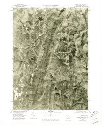
 1973 Cheshire1975 Print · USGSThe high Berkshires meet the industrial Hoosic River valley in the early seventies, capturing a landscape of mountain trails and rail-side settlements. Researchers can trace the Appalachian Trail over Mt Greylock or locate ancestral sites like the Riverside Cem and Talcott Sch.2 unique versions available
 - 1973 Map of North Adams, 1975 Print
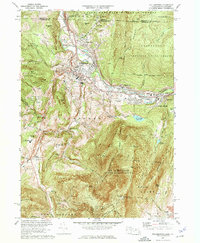
 1973 North Adams1975 Print · USGSNorth Adams and its neighboring mountain townships are shown in the early seventies, a landscape where industrial valleys meet state forest peaks. Genealogists and historians can trace rail routes through the Hoosac Tunnel or locate ancestral sites like Hillside Cem and Briggsville.4 unique versions available
 - 1973 Map of Windsor, 1975 Print
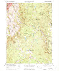 1973 Windsor1975 Print · USGSThe Berkshires transition from the industrial valley of Adams into the high forest lands of Savoy and Windsor during the early 1970s. Genealogists and hikers can trace family sites at Bellevue Cemetery or explore landmarks like Memorial Tower and Borden Mtn.2 unique versions available
 - 1975 Map of Windsor, 1981 Print
 1975 Windsor1981 Print · USGSThe Berkshire highlands are captured in the mid-seventies in this detailed aerial survey. Genealogists and local historians can trace the rural layouts of Windsor and Savoy, or locate the specific topography around Borden Mountain.
 - 1975 Map of Cheshire, 1981 Print
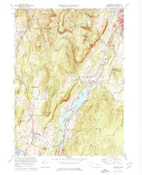
 1975 Cheshire1981 Print · USGSBerkshire County at the midpoint of the 1970s reveals a landscape of concentrated valley towns and wooded ridges. Trace the boundaries of Cheshire and Adams or locate lakeside landmarks near Cheshire Reservoir and Pontoosuc Lake.
 - 1975 Map of Williamstown, 1981 Print
 1975 Williamstown1981 Print · USGSThe Berkshires in the mid-1970s are captured in this aerial survey, detailing the industrial and academic corridor of the Hoosic River valley. Researchers can trace land use patterns across Williamstown, North Adams, and the slopes of Mt Greylock.
 - 1975 Map of North Adams, 1981 Print
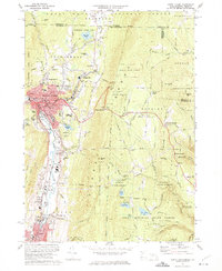
 1975 North Adams1981 Print · USGSNorthern Berkshire County is documented during the mid-seventies, showing the valley floor as it transitions from industrial centers to high peaks. Researchers can trace land use patterns near North Adams, Zylonite, and the steep terrain around Whitcomb Summit.
End of results
Showing maps 1-8 of 8
Top cities near Adams
- Pittsfield historical maps
- North Adams historical maps
- Bennington historical maps
- Williamstown historical maps
- Hoosick historical maps
- Dalton historical maps
See more
Top neighborhoods of Adams
- Maple Grove historical maps
- East Renfrew historical maps
- Bowens Corners historical maps
- Little Egypt historical maps
- Zylonite historical maps
- Summer Street Historic District historical maps
Frequently asked questions
- What are the different types of historical maps available for Adams?
- What is the oldest map of Adams?
- Where can I purchase historical maps of Adams for my home or office?
- Where can I download high-res historical maps of Adams?
- Are there historical topographic maps available for Adams?
- Is there historical aerial imagery available for Adams?
- Where are historical maps of Adams sourced from?