1900s (20th Century) Maps of Bristol County, Massachusetts
Explore 144 historic maps of Bristol County from the 1900s (20th Century). These maps offer a rare glimpse into what life looked like during the 1900s — showing old roads, neighborhoods, homes, and landmarks that have changed or disappeared over time.
Whether you're researching your family's past, planning a metal detecting trip, or studying how Bristol County's landscape evolved across the 1900s, these high-resolution maps are a powerful tool for exploring the history of this region.
- Focus on a specific era: All maps on this page are from the 1900s, giving you a focused view of this time period.
- See what’s changed: Compare century-old streets, trails, and buildings to today's modern landscape using overlays and satellite layers.
- Research with precision: Use these maps for genealogy, historical research, land use analysis, or educational projects.
- View, download, or print: Maps are fully viewable online in high resolution, and can be downloaded or printed for your own records.
Start exploring Bristol County's history through authentic maps from the 1900s. This is your window into the past.
Bristol County, MA maps
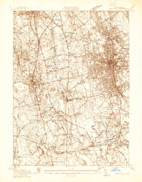
(144)- 1916 Map of Middleboro
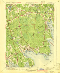
 1916 Middleboro1916 Print · USGSSoutheastern Massachusetts at the height of its rail-and-mill era shows a dense network of stations and wetlands. Trace the Old Colony Railroad lines to sites like Haskins Station, Paper Mill Village, and the Lakeville State Sanatarium.
 - 1918 Map of Middleboro, 1921 Print
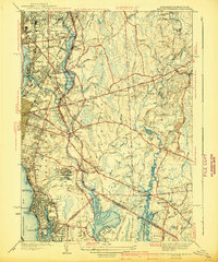
 1918 Middleboro1921 Print · USGSSoutheastern Massachusetts at the end of the Great War reveals a landscape defined by cranberry bogs, cedar swamps, and a dense network of Old Colony Railroad lines. Genealogists and historians can trace rail stops like Haskins Station, the grounds of the Lakeville State Sanatarium, and old villages like The Green.
 - 1918 Map of New Bedford, 1921 Print
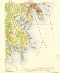
 1918 New Bedford1921 Print · USGSThe Buzzards Bay coastline thrived with rail and maritime commerce during the early twentieth century. Researchers can trace historic shorelines and infrastructure at New Bedford, Fairhaven, and Clark Point Light.
 - 1918 Map of Taunton, 1921 Print
 1918 Taunton1921 Print · USGSSoutheastern Massachusetts at the close of the Great War is a dense network of industrial rail lines and riverside villages. You can trace the path of the Old Colony Railroad Main Line or locate local landmarks like the Copper Works and Annawon Rock.
 - 1919 Map of Dedham
 1919 Dedham1919 Print · USGSNorfolk County at the close of the Great War reveals a landscape defined by the Blue Hills Reservation and a dense network of industrial rail lines. Genealogists and historians can trace old neighborhood boundaries in Readville and Islington or locate lost trackside stops along the Old Colony RR.
 - 1919 Map of Fall River
 1919 Fall River1919 Print · USGSThe coastal borderlands of Massachusetts and Rhode Island are captured here just after the Great War, showing the transition from industrial Fall River to rural seaside hamlets. Genealogists can locate family landmarks in Little Compton The Commons, trace the Old Colony Railroad, or explore old landings at Westport Point.
 - 1919 Map of Franklin
 1919 Franklin1919 Print · USGSEastern Massachusetts at the end of the Great War was a landscape defined by its river-powered mill towns and expanding rail corridors. Genealogists and local historians can trace family roots through industrial hamlets like City Mills, Unionville, and Sheldonville.2 unique versions available
 - 1919 Map of Narragansett Bay, 1921 Print
 1919 Narragansett Bay1921 Print · USGSThe Rhode Island coast thrived as a hub of rail and maritime activity during the early twentieth century. Genealogists and historians can trace rail lines like the Sea View Electric R.R. and locate old landmarks like the Portsmouth Coal Mines and State Farm.2 unique versions available
 - 1921 Map of Providence
 1921 Providence1921 Print · USGSProvidence and its industrial satellites are captured here at the height of the rail-and-mill era. Genealogists and historians can trace old neighborhoods and worksites like Sayles Bleachery, the Dexter Asylum, and Lonsdale Station.
 - 1921 Map of Franklin, 1942 Print
 1921 Franklin1942 Print · USGSThe Charles River valley was a network of bustling rail junctions and mill villages in the years following the Great War. You can trace the development of towns like Franklin and Medway or locate smaller centers such as City Mills and Unionville.
 - 1936 Map of New Bedford North
 1936 New Bedford North1936 Print · USGSGreater New Bedford in the mid-thirties shows a fascinating contrast between its bustling riverfront and the expansive cedar swamps to the north. Genealogists and historians can trace family plots in Riverside Cem, locate the Bluestone Quarry, or find old schoolhouses like the Faunces Cor Sch.
 - 1936 Map of Mansfield
 1936 Mansfield1936 Print · USGSMansfield and its neighboring villages are shown during the mid-1930s, when the region functioned as a vital railway hub for the New York New Haven and Hartford RR. Researchers can locate family sites and old landmarks like Furnace Village, St Marys Cem, and the Hartwell Sch.
 - 1936 Map of Marion
 1936 Marion1936 Print · USGSBuzzards Bay coastal life and the cranberry industry are captured here in the mid-1930s. Genealogists and historians can trace family plots at Hammond Cem and explore landmarks like Marion Station or the Neds Point Light.
 - 1936 Map of South Dartmouth
 1936 South Dartmouth1936 Print · USGSCoastal Bristol County is captured here in the mid-1930s, showing a landscape defined by maritime navigation and harbor defenses. Researchers can trace early aviation at the Round Hill Landing Field and locate family landmarks like Crapo Sch or the Rural Cemetery.
 - 1936 Map of Brockton
 1936 Brockton1936 Print · USGSBrockton and Stoughton are captured here during the mid-1930s, showing a landscape of burgeoning industrial centers and rural family corners. Researchers can trace ancestral roots through dozens of named cemeteries like Washington Cem or locate old industrial sites like Oconnors Cider Mill and the Brockton Filter Beds.
 - 1937 Map of Assawompset Pond
 1937 Assawompset Pond1937 Print · USGSThe Lakeville and Freetown area in the late thirties is defined by its massive pond systems and a transition toward regional water management. Genealogists can locate family burial grounds like Strowbridge Cem or trace the early industrial footprint of Bettys Neck Cranberry Co and the Taunton Water Works.
 - 1937 Map of Middleboro
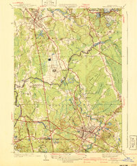
 1937 Middleboro1937 Print · USGSThe rail-and-river hub of Middleborough and its surrounding cranberry bogs are frozen in time just before the war. Researchers can trace family roots at Purchase Cem, locate the Thompsonville Sch, or follow the New York New Haven and Hartford railroad line.
 - 1938 Map of Pawtucket, 1941 Print
 1938 Pawtucket1941 Print · USGSIndustrial Rhode Island at the end of the Depression era is defined here by the river towns of the Blackstone Valley. Genealogists can locate several historic burial sites, including Polish Cem and Clarks Cem, or trace early industrial landmarks like Arnolds Mills.
 - 1939 Map of Bristol, 1953 Print
 1939 Bristol1953 Print · USGSCoastal Rhode Island just before the war shows a landscape of busy maritime towns and expanding shorefront neighborhoods. Trace the foundations of the community through the Soldiers Home, Juniper Hill Cem, and the New Haven and Hartford RR line.2 unique versions available
 - 1940 Map of Wrentham
 1940 Wrentham1940 Print · USGSNorfolk County in the late 1930s shows a landscape of busy mill villages and expanding state institutions. Genealogists can trace family roots through the Bacon Cem, Quaker Cem, and local schools like Vogel Sch and Everett Sch.2 unique versions available
 - 1940 Map of Bridgewater
 1940 Bridgewater1940 Print · USGSSoutheastern Massachusetts at the dawn of the 1940s reveals a landscape shaped by state institutions and the cranberry industry. Researchers can trace family sites near The Green, find the Fair Grounds, or locate old schoolhouses like the Pleasant Street School.3 unique versions available
 - 1940 Map of Sconticut Neck
 1940 Sconticut Neck1940 Print · USGSCoastal Fairhaven and its surrounding islands appear here in the mid-1930s, showing the early layout of the peninsula and its maritime borders. Trace the path of Sconticut Neck Road to the tip at Sconticut Point or explore the shores of West Island.3 unique versions available
 - 1941 Map of Marion
 1941 Marion1941 Print · USGSThe Buzzards Bay coastline flourished in the late 1930s with a blend of maritime education, rail commerce, and seaside recreation. Genealogists and historians can trace family burial sites at Barlow Cem, locate the landmark Tabor Academy, and follow the New York New Haven and Hartford railroad.3 unique versions available
 - 1941 Map of East Providence
 1941 East Providence1941 Print · USGSThe Rhode Island and Massachusetts borderlands show a unique mix of urban growth and coastal tradition in the late 1930s. Researchers can trace family roots through numerous local landmarks like Newman Ave Sch, Hurst Cemetery, and the Narragansett Race Track.3 unique versions available
 - 1941 Map of New Bedford South
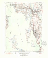
 1941 New Bedford South1941 Print · USGSCoastal Massachusetts at the start of the 1940s reveals a landscape of harbor defenses, seaside villages, and rural schools. Researchers can trace historic family-named landmarks and institutions like Fort Phoenix, St Johns Ch, and the Padanaram Breakwater.3 unique versions available
Showing maps 1-25 of 144
Top cities of Bristol County
- New Bedford historical maps
- Fall River historical maps
- Taunton historical maps
- Attleboro historical maps
- Dartmouth historical maps
- North Attleborough historical maps
See more
Frequently asked questions
- What are the different types of historical maps available for Bristol County?
- What is the oldest map of Bristol County?
- Where can I purchase historical maps of Bristol County for my home or office?
- Where can I download high-res historical maps of Bristol County?
- Are there historical topographic maps available for Bristol County?
- Is there historical aerial imagery available for Bristol County?
- Where are historical maps of Bristol County sourced from?