1970s Maps of Bristol County, Massachusetts
Explore 29 historic maps of Bristol County from the 1970s. These maps offer a rare glimpse into what life looked like during the 1970s — showing old roads, neighborhoods, homes, and landmarks that have changed or disappeared over time.
Whether you're researching your family's past, planning a metal detecting trip, or studying how Bristol County's landscape evolved across the 1970s, these high-resolution maps are a powerful tool for exploring the history of this region.
- Focus on a specific era: All maps on this page are from the 1970s, giving you a focused view of this time period.
- See what’s changed: Compare century-old streets, trails, and buildings to today's modern landscape using overlays and satellite layers.
- Research with precision: Use these maps for genealogy, historical research, land use analysis, or educational projects.
- View, download, or print: Maps are fully viewable online in high resolution, and can be downloaded or printed for your own records.
Start exploring Bristol County's history through authentic maps from the 1970s. This is your window into the past.
Bristol County, MA maps
(29)- 1971 Map of East Providence, 1973 Print
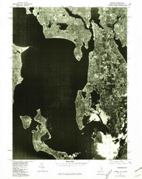
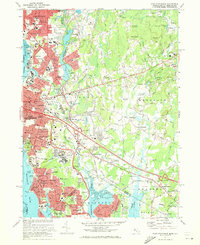 1971 East Providence1973 Print · USGSThe Rhode Island and Massachusetts borderlands come alive in the early seventies, showing a mix of coastal industry and suburban sprawl. Genealogists can trace family names at Gate of Heaven Cem and explore landmarks like McCoy Stadium or Crescent Amusement Park.4 unique versions available
 - 1972 Map of Cuttyhunk, 1973 Print
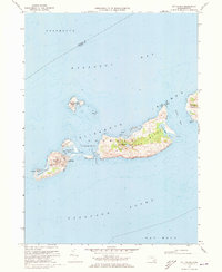 1972 Cuttyhunk1973 Print · USGSThe Elizabeth Islands at the start of the seventies reveal a remote maritime landscape centered on the village of Cuttyhunk. Researchers can trace old coastal landmarks like the Lighthouse, the local Cem, and the topography of Nashawena Island.3 unique versions available
 - 1975 Map of Brockton, 1977 Print
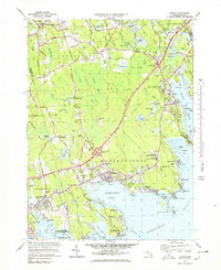
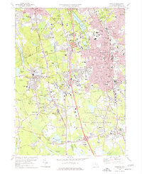 1975 Brockton1977 Print · USGSThe city of Brockton and surrounding towns are shown in the mid-seventies just as the modern highway system was fully integrating with old village centers. Researchers can trace historic institutions and local landmarks like Stonehill College, Stoughton Junction, and the Hockomock Swamp.2 unique versions available
 - 1975 Map of Sconticut Neck, 1977 Print
 1975 Sconticut Neck1977 Print · USGSThe Fairhaven coastline at the mid-seventies is defined by the narrow reach of Sconticut Neck and the offshore community of West Island. Local researchers can trace the residential road networks and identify coastal landmarks like Silver Shell Beach, Wilbur Pt, and the Causeway.2 unique versions available
 - 1975 Map of Bristol, 1981 Print
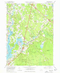
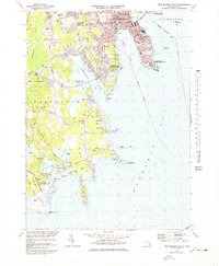
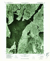
 1975 Bristol1981 Print · USGSNarragansett Bay and its surrounding coastal communities are captured in this mid-seventies aerial study. Genealogists and historians can trace the mid-century footprints of Bristol, Warren, and the northern reaches of Prudence Island.
 - 1977 Map of Assonet
 1977 Assonet1977 Print · USGSCoastal Massachusetts at the height of the 1970s shows a landscape of tidal rivers and growing infrastructure near the Bristol and Plymouth county lines. Genealogists and local historians can trace family plots at Old Quaker Cem or Richmond Cem and locate landmarks like Old Town Landing.3 unique versions available
 - 1977 Map of Bridgewater, 1978 Print
 1977 Bridgewater1978 Print · USGSBridgewater and Middleboro appear in the late seventies as significant rail and river hubs south of Brockton. Genealogists and local historians can trace family plots at St Marys Cem or locate the Pratt Free Sch and Paper Mill Village.3 unique versions available
 - 1977 Map of Westport, 1979 Print
 1977 Westport1979 Print · USGSThe coastal stretches of Westport and Dartmouth appear here in the mid-seventies, showing a landscape of salt marshes, barrier beaches, and river estuaries. Genealogists and researchers can trace lineage through old village centers like Westport Point and the Friends Meeting House, or find family-named crossroads such as Gidleys Corner.5 unique versions available
 - 1977 Map of New Bedford South, 1979 Print
 1977 New Bedford South1979 Print · USGSThe coastal stretches of South Dartmouth and New Bedford are captured here in the late seventies, showing a landscape of maritime history and suburban growth. Genealogists can trace family plots and local landmarks like Rural Cemetery, Potomska Cem, and the De Mello Sch.3 unique versions available
 - 1977 Map of Marion, 1979 Print
 1977 Marion1979 Print · USGSCoastal life in the late seventies is centered on the harbor towns of Marion and Mattapoisett during a period of modern infrastructure expansion. Genealogists and historians can trace family roots through Barlow Cem, the historic Sturtevant Mill, and local schools like Tabor Academy.4 unique versions available
 - 1977 Map of Attleboro, 1981 Print
 1977 Attleboro1981 Print · USGSThe industrial and residential landscape of the Massachusetts-Rhode Island border is seen here in the late seventies. Researchers can trace the development of North Attleboro and Attleboro along the path of the Ten Mile River.
 - 1977 Map of Taunton, 1981 Print
 1977 Taunton1981 Print · USGSThe Bristol County landscape in the late seventies is shown in photographic detail, capturing the dense street patterns and suburban growth around the Taunton River. Researchers can trace the layout of Taunton and Raynham Center or locate properties near the shores of Lake Nippenicket.
 - 1977 Map of Norton, 1981 Print
 1977 Norton1981 Print · USGSBristol County during the late seventies is revealed through detailed aerial imagery, showing the expansion of local settlements. Researchers can trace the exact 1977 footprints of Norton, West Mansfield, and the banks of Norton Reservoir.
 - 1977 Map of Cuttyhunk, 1981 Print
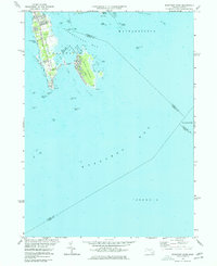
 1977 Cuttyhunk1981 Print · USGSThe Elizabeth Islands are seen in detail during the late 1970s, showing the remote maritime landscape of Dukes County. Trace the settlement of Cuttyhunk and the coastal contours of Nashawena Island and Penikese Island.
 - 1977 Map of Mansfield, 1981 Print
 1977 Mansfield1981 Print · USGSIn the late 1970s, the South Shore region was balancing suburban growth with its dense woodlands and waterways. Study the exact 1977 footprints of Mansfield and Sharon, or trace the banks of Massapoag Lake and the Canoe River.
 - 1977 Map of Sconticut Neck, 1981 Print
 1977 Sconticut Neck1981 Print · USGSThe Bristol County coast appears as it did in the late seventies through this detailed aerial imagery. Local historians can trace the development patterns across Sconticut Neck, the connection to West Island, and the shoreline of Buzzards Bay.
 - 1977 Map of Assawompset Pond, 1981 Print
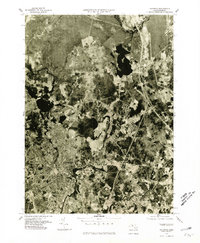
 1977 Assawompset Pond1981 Print · USGSSoutheastern Massachusetts in the late seventies is captured here through detailed orthophotography of its vast lake system. Genealogists and researchers can trace local landmarks like Masons Corner, Lakeville, and the waters of Assawompset Pond.
 - 1977 Map of Somerset, 1981 Print
 1977 Somerset1981 Print · USGSBristol County during the late 1970s is seen here in detailed aerial photography, showing the coastal and riverine landscapes before modern expansion. Researchers can trace property patterns and water routes from Somerset up to the crossroads at Perrys Corner.
 - 1977 Map of Fall River East, 1981 Print
 1977 Fall River East1981 Print · USGSEastern Fall River and Westport come into focus during the late seventies, showing the transition from textile-era industrial sites to modern infrastructure. Trace old land patterns near Westport Factory, Hixville, and the shores of North Watuppa Pond.
 - 1977 Map of Fall River, 1981 Print
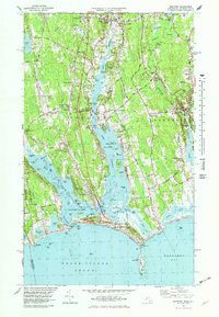
 1977 Fall River1981 Print · USGSThe industrial waterfront of Bristol County comes into sharp focus during the late seventies, showing the dense urban reaches of Fall River and its neighboring towns. Trace the development of waterfront communities like Ocean Grove and the shorelines of Mount Hope Bay.
 - 1977 Map of Brockton, 1981 Print
 1977 Brockton1981 Print · USGSBrockton and the surrounding Plymouth County townships appear in this detailed photographic study from the late seventies. Researchers can trace the exact 1977 footprints of settlements like Five Corners, North Easton, and West Bridgewater.
 - 1977 Map of New Bedford North, 1981 Print
 1977 New Bedford North1981 Print · USGSCoastal Massachusetts at the end of the 1970s reveals a landscape of industrial harbor towns and expanding northern woods. Trace the dense street grids of New Bedford and Fairhaven or locate early development near Acushnet and Braleys.
 - 1977 Map of Wrentham, 1981 Print
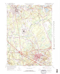
 1977 Wrentham1981 Print · USGSEastern Massachusetts is revealed through 1970s aerial imagery during a period of significant suburban growth. Researchers can pinpoint the exact locations of family homes and businesses in Wrentham, Shepardville, and Plainville at this specific moment in history.
 - 1977 Map of East Providence, 1981 Print
 1977 East Providence1981 Print · USGSThe Rhode Island and Massachusetts borderlands appear in high detail during the late seventies, showing the transition from urban centers to rural townships. Trace property patterns and water routes like the Ten Mile River near East Providence and Seekonk.
 - 1978 Map of Assawompset Pond, 1979 Print
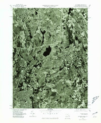
 1978 Assawompset Pond1979 Print · USGSSoutheastern Massachusetts in the late seventies reveals a landscape defined by the great ponds and the cranberry industry. Researchers can trace family sites near Lakeville or locate historic burying grounds like Strowbridge Cem and Wapanucket Cem.
Showing maps 1-25 of 29
Top cities of Bristol County
- New Bedford historical maps
- Fall River historical maps
- Taunton historical maps
- Attleboro historical maps
- Dartmouth historical maps
- North Attleborough historical maps
See more
Frequently asked questions
- What are the different types of historical maps available for Bristol County?
- What is the oldest map of Bristol County?
- Where can I purchase historical maps of Bristol County for my home or office?
- Where can I download high-res historical maps of Bristol County?
- Are there historical topographic maps available for Bristol County?
- Is there historical aerial imagery available for Bristol County?
- Where are historical maps of Bristol County sourced from?