Old Maps of Bristol County, Massachusetts for Hiking & Exploration
Hike through history with 287 historic maps of Bristol County. Explore old trails, ghost towns, and forgotten backroads — perfect for outdoor adventurers and local explorers.
- Rediscover forgotten places: Map out old mining camps, roads, and footpaths that no longer exist on modern maps.
- Layer with modern tools: Combine with LiDAR or satellite views to plan hikes through historical terrain.
- Made for exploration: Popular among hikers, overlanders, and local history lovers.
Use these maps to find adventure and explore the hidden past of Bristol County.
Bristol County, MA maps
(287)- 1885 Map of New Bedford
 1885 New Bedford1885 Print · USGSThe Buzzards Bay coastline and its industrial hubs are captured here as the maritime economy met the rising age of rail. Genealogy and local history researchers can trace the streets of New Bedford, the tracks of the Old Colony Railroad, and coastal landmarks like Clark Point Light.
 - 1885 Map of Sakonnet
 1885 Sakonnet1885 Print · USGSThe Rhode Island coast south of Little Compton and Middletown is captured here in the late nineteenth century, showing a shoreline defined by points and coastal ponds. Researchers can trace landforms and landmarks like Sakonnet Point, Woods Castle, and Sachuest Neck.
 - 1885 Map of Middleboro
 1885 Middleboro1885 Print · USGSPlymouth County at the height of its nineteenth-century rail expansion is anchored by the hub at Middleboro. Genealogists and historians can trace defunct stops like Haskins Station and Rock Station or locate families in The Green and Paper Mill Village.
 - 1885 Map of Taunton
 1885 Taunton1885 Print · USGSTaunton and the surrounding Bristol County townships are shown here during a period of significant industrial and rail expansion. Researchers can trace historic family landmarks and local institutions like the State Hospital for the Insane, Dighton Rock, and the Swansea Factory.
 - 1886 Map of Dedham
 1886 Dedham1886 Print · USGSNorfolk County and its neighbors are captured here in the late nineteenth century as the rail networks expanded across eastern Massachusetts. Local historians can trace the routes of the Old Colony Railroad and find early village sites like Furnace Village and Sharon Heights.
 - 1887 Map of Franklin
 1887 Franklin1887 Print · USGSNorfolk County at the peak of the industrial rail era shows a complex landscape of mill villages and expanding transit lines. Trace the development of City Mills, follow the Old Colony R. R. Wrentham Branch, or locate old landmarks like Burnt Swamp Corner.
 - 1887 Map of Gay Head
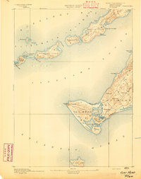
 1887 Gay Head1887 Print · USGSThe islands of Dukes County appear in their late nineteenth-century character, spanning from the heights of Chilmark to the chain of the Elizabeth Islands. Genealogists and historians can trace family-named sites and coastal landmarks like Gay Head Light, the settlement of Squibnocket, and Tarpaulin Cove.
 - 1887 Map of Providence
 1887 Providence1887 Print · USGSProvidence and its surrounding mill towns are captured here at the height of the industrial era. Trace the rail-and-river infrastructure of the Blackstone River through Lorraine Mills, Saylesville, and the Cranston Print Works.
 - 1888 Map of New Bedford
 1888 New Bedford1888 Print · USGSThe bustling whale oil and textile hub of New Bedford is shown here at its maritime peak in the late nineteenth century. Genealogists can trace early neighborhood grids and find outlying rural stops like Braleys Station, Turners Mills, and Nasketucket.
 - 1888 Map of Fall River
 1888 Fall River1888 Print · USGSCoastal Massachusetts and Rhode Island are captured here in the late nineteenth century as industry and agriculture thrived side-by-side. Genealogists and researchers can trace the early rail networks of the Old Colony Railroad or locate family homesteads near Tiverton Four Corners and Little Compton.
 - 1888 Map of Taunton
 1888 Taunton1888 Print · USGSIn the late nineteenth century, this region of Bristol County was a bustling industrial and rail center. Researchers can trace the extensive Old Colony Railroad network through specialized stops like Britanniaville Station and Cranes Station.
 - 1888 Map of Middleboro
 1888 Middleboro1888 Print · USGSPlymouth County in the late nineteenth century is a bustling intersection of iron and water, where the Old Colony Railroad branches reach across the landscape. Genealogists and historians can trace the early footprints of Paper Mill Village, The Green, and Haskins Station before modern development changed these local centers.
 - 1888 Map of Sakonnet
 1888 Sakonnet1888 Print · USGSCoastal Rhode Island in the 1880s was defined by its weather-beaten points and maritime outposts. Genealogists and historians can trace the early topography of Little Compton and Middletown, from Sakonnet Point to Woods Castle.
 - 1889 Map of Gay Head
 1889 Gay Head1889 Print · USGSThe western end of Martha's Vineyard and the Elizabeth Islands appear here in the late nineteenth century, defined by a maritime economy of lighthouses and small coastal settlements. Researchers can trace historic landmarks like Gay Head Light, Chilmark, and the remote No Mans Land.
 - 1889 Map of Providence
 1889 Providence1889 Print · USGSProvidence and its industrial corridors thrive at the close of the nineteenth century as a massive rail-and-water network takes shape. Genealogists and historians can trace the foundations of local industry at the Sayles Bleachery or locate long-standing institutions like Friends School and Dexter Asylum.
 - 1889 Map of Franklin
 1889 Franklin1889 Print · USGSThe industrial and rail hubs of Norfolk County are detailed in the late 1880s, documenting a time of rapid growth for mill towns and village centers. Researchers can trace historic station stops and hamlets like City Mills, Unionville, and Whitney Sta.
 - 1890 Map of Narragansett Bay
 1890 Narragansett Bay1890 Print · USGSNarragansett Bay's western shore comes to life in the late nineteenth century, showing a landscape of rail-linked villages and coastal landmarks. Genealogists and historians can trace old homesteads and transit hubs from Wickford Junction to the State Farm and the Bristol Ferry.
 - 1892 Map of Narragansett Bay
 1892 Narragansett Bay1892 Print · USGSNarragansett Bay in the late nineteenth century reveals a coastline defined by maritime commerce and early rail connectivity. Genealogists can trace family roots in old village centers like Wickford, Apponaug, and Conimicut, or locate the State Prison near Natick.8 unique versions available
 - 1893 Map of Taunton
 1893 Taunton1893 Print · USGSTaunton flourished as a rail and manufacturing powerhouse during the late nineteenth century, situated at the nexus of the Old Colony Railroad system. Genealogists and historians can trace the early industrial sites like the Copper Works and Swansea Factory or find local landmarks such as Dighton Rock and the town Almshouse.7 unique versions available
 - 1893 Map of Franklin
 1893 Franklin1893 Print · USGSEastern Massachusetts at the close of the nineteenth century was a landscape of busy rail junctions and riverside mill towns. Researchers can trace the era's industrial footprint through sites like City Mills, Medfield Junc., and the isolated Burnt Swamp Corner.8 unique versions available
 - 1893 Map of Gay Head
 1893 Gay Head1893 Print · USGSThe islands of Marthas Vineyard and the Elizabeth Islands appear here in the late nineteenth century. Researchers can trace the coastal geography of Chilmark, the prominent Gay Head Light, and the isolated reaches of Cuttyhunk Island and No Mans Land.7 unique versions available
 - 1893 Map of Middleboro
 1893 Middleboro1893 Print · USGSThe Plymouth County landscape in the 1890s is captured here as a major rail hub. Genealogists can trace family footprints near Rock Station, the mills of Paper Mill Village, and along the shores of Assawompsett Pond.8 unique versions available
 - 1893 Map of Sakonnet
 1893 Sakonnet1893 Print · USGSThe Rhode Island coast in the late nineteenth century is documented here as a maritime landscape of rocky points and tidal ponds. Researchers can trace the early harbor works at Sakonnet Point or locate family landmarks like Woods Castle and Warren Point.6 unique versions available
 - 1893 Map of Fall River
 1893 Fall River1893 Print · USGSCoastal Massachusetts and Rhode Island are captured here in the late nineteenth century as the textile industry and railroads reshaped the waterfront. Genealogists and local historians can trace early family holdings and hubs like Globe Village, Tiverton Four Corners, and the old Bordens Wharf.9 unique versions available
 - 1893 Map of New Bedford
 1893 New Bedford1893 Print · USGSThe South Coast of Massachusetts is captured here in the late nineteenth century as a hub of maritime trade and rail transit. Researchers can trace the waterfront development of New Bedford, find old coastal lights like Neds Point Light, and locate family settlements at Potomska and Apponagansett.9 unique versions available
Showing maps 1-25 of 287
Top cities of Bristol County
- New Bedford historical maps
- Fall River historical maps
- Taunton historical maps
- Attleboro historical maps
- Dartmouth historical maps
- North Attleborough historical maps
See more
Frequently asked questions
- What are the different types of historical maps available for Bristol County?
- What is the oldest map of Bristol County?
- Where can I purchase historical maps of Bristol County for my home or office?
- Where can I download high-res historical maps of Bristol County?
- Are there historical topographic maps available for Bristol County?
- Is there historical aerial imagery available for Bristol County?
- Where are historical maps of Bristol County sourced from?