2020s Maps of Huntington, Massachusetts
Explore 8 historic maps of Huntington from the 2020s. These maps offer a rare glimpse into what life looked like during the 2020s — showing old roads, neighborhoods, homes, and landmarks that have changed or disappeared over time.
Whether you're researching your family's past, planning a metal detecting trip, or studying how Huntington's landscape evolved across the 2020s, these high-resolution maps are a powerful tool for exploring the history of this region.
- Focus on a specific era: All maps on this page are from the 2020s, giving you a focused view of this time period.
- See what’s changed: Compare century-old streets, trails, and buildings to today's modern landscape using overlays and satellite layers.
- Research with precision: Use these maps for genealogy, historical research, land use analysis, or educational projects.
- View, download, or print: Maps are fully viewable online in high resolution, and can be downloaded or printed for your own records.
Start exploring Huntington's history through authentic maps from the 2020s. This is your window into the past.
Huntington, MA maps
(8)- 2021 Map of Chester, 2021 Print
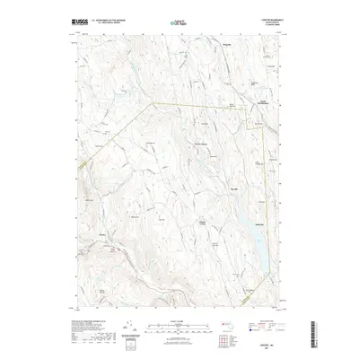 2021 Chester2021 Print · USGSCovers Huntington, including Chester, Blandford, and other nearby areas
 - 2021 Map of Westhampton, 2021 Print
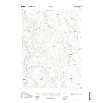 2021 Westhampton2021 Print · USGSCovers Huntington, including Southampton, Williamsburg, and other nearby areas
 - 2021 Map of Woronoco, 2021 Print
 2021 Woronoco2021 Print · USGSCovers Huntington, including Westfield, Southampton, and other nearby areas
 - 2021 Map of Blandford, 2021 Print
 2021 Blandford2021 Print · USGSCovers Huntington, including Russell, Granville, and other nearby areas
 - 2024 Map of Woronoco, 2024 Print
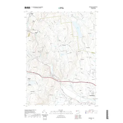
 2024 Woronoco2024 Print · USGSHampden and Hampshire counties meet here in this contemporary survey of the Westfield River valley and its highland settlements. You can trace the rural landscape through family landmarks like Clarks Cem, the campus of Westfield State College, and the winding CSX TRANSPORTATION rail corridor.
 - 2024 Map of Blandford, 2024 Print
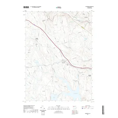
 2024 Blandford2024 Print · USGSThe hilltop village of Blandford and its surrounding reservoirs are captured here in the 2020s. Genealogists can locate several family burial sites like Hubbard Cem and Warfield Cem or trace the early paths of John Knox Road Trl.
 - 2024 Map of Chester, 2024 Print
 2024 Chester2024 Print · USGSThe hills of the Hampshire and Hampden border appear in high detail during this era of rural preservation. Researchers can locate early family plots like Ireland Street Cem and Converse Cem, or trace the industrial roots of Chester Factory.
 - 2024 Map of Westhampton, 2024 Print
 2024 Westhampton2024 Print · USGSHampshire County's highland terrain comes alive in this contemporary survey of the eastern Berkshires. Genealogists and historians can locate numerous early burial sites like Damon Burying Ground Cem and trace the legacy of the Bisbee Mill near Westhampton.
End of results
Showing maps 1-8 of 8
Top cities near Huntington
- Westfield historical maps
- Holyoke historical maps
- Northampton historical maps
- Agawam historical maps
- West Springfield historical maps
- Easthampton historical maps
See more
Top neighborhoods of Huntington
- Littleville Lake historical maps
- Norwich historical maps
- Goss Heights historical maps
- Knightville historical maps
Frequently asked questions
- What are the different types of historical maps available for Huntington?
- What is the oldest map of Huntington?
- Where can I purchase historical maps of Huntington for my home or office?
- Where can I download high-res historical maps of Huntington?
- Are there historical topographic maps available for Huntington?
- Is there historical aerial imagery available for Huntington?
- Where are historical maps of Huntington sourced from?