Old Maps of Boxborough, Massachusetts for Metal Detecting
Plan your next treasure hunt with 71 historic maps of Boxborough. Find old homesites, ghost towns, trails, and gathering spots that may be lost to time — perfect for identifying promising metal detecting locations.
- Locate forgotten sites: Uncover places like long-lost settlements, abandoned rail lines, or gathering spots.
- Plan better hunts: Use map overlays combined with LiDAR or satellite views to narrow in on historically rich areas.
- Made for detectorists: Thousands of hobbyists use these maps to discover relics, coins, and hidden history.
Use these historic maps to boost your research and find new opportunities beneath the surface of Boxborough.
Boxborough, MA maps
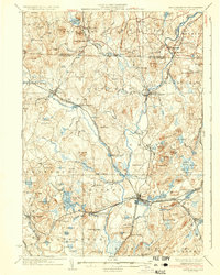
(71)- 1886 Map of Lowell
 1886 Lowell1886 Print · USGSThe industrial heart of the Merrimack Valley is captured here in the late nineteenth century, showing the expansion of textile hubs and rail networks. Genealogists and historians can trace family-named hills and early transit stops like Bedford Springs Station, Forge Village, and the Hudson Poor Farm.
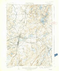
 - 1886 Map of Framingham
 1886 Framingham1886 Print · USGSMiddlesex County emerges as a bustling hub of rail transit and water infrastructure at the close of the 1800s. Genealogists and historians can trace family locations near the Mass. State Muster Grounds, the State Prison, or the historic Wayside Inn.
 - 1887 Map of Marlboro
 1887 Marlboro1887 Print · USGSWorcester County is captured during its industrial transition, showing the vital rail and water networks connecting the region. Researchers can trace the development of the Metropolitan Waterworks Aqueduct and locate landmarks like the Westboro Insane Hospital and Lyman School.
 - 1889 Map of Marlboro
 1889 Marlboro1889 Print · USGSCentral Massachusetts at the close of the 1880s was a bustling hub of rail activity and industrial development. Local historians can trace early transportation routes like the Fitchburg Railroad through Still River Station and find old-world village names like Rock Bottom and Straw Hollow.
 - 1889 Map of Framingham
 1889 Framingham1889 Print · USGSThe Framingham and Concord region flourished as a late nineteenth-century rail and industrial hub. Genealogists and historians can trace the early layouts of Saxonville, the American Powder Co., and the Mass. State Muster Grounds.
 - 1893 Map of Lowell
 1893 Lowell1893 Print · USGSThe Merrimack Valley’s industrial and rail landscape comes alive in the late nineteenth century, centering on the growing city of Lowell. Genealogists and historians can trace old property lines across Pelham, locate the Flat Rock Quarry, or follow the routes of the Stony Brook Railroad through Graniteville.9 unique versions available
 - 1893 Map of Groton, 1905 Print
 1893 Groton1905 Print · USGSNorthern Massachusetts and the New Hampshire borderlands are shown here in the late nineteenth century as a hub of river industry and rail commerce. Researchers can trace historic sites like Shaker Village, the Groton School, and manufacturing hubs at Paper Mill Village.8 unique versions available
 - 1894 Map of Framingham
 1894 Framingham1894 Print · USGSMiddlesex County in the late nineteenth century is a landscape of thriving rail depots and literary landmarks. Genealogists and historians can trace the foundations of local life at the Wayside Inn, the State Prison, and the Mass. State Muster Grounds.11 unique versions available
 - 1896 Map of Marlboro
 1896 Marlboro1896 Print · USGSCentral Massachusetts in the late nineteenth century is a landscape of thriving mill towns and interlocking rail lines. Researchers can trace the Victorian-era footprints of Marlboro and Clinton, locating vanished stops like Still River Station and family landmarks like Whittemore Hill.
 - 1898 Map of Marlboro
 1898 Marlboro1898 Print · USGSCentral Massachusetts was a thriving network of rail and river industry at the end of the Victorian era. Genealogists and historians can trace the early layouts of manufacturing hubs like Clinton and Hudson or find smaller vanished locales like Rockbottom and Pratt Junction.8 unique versions available
 - 1908 Map of Quinsigamond
 1908 Quinsigamond1908 Print · USGSCentral Massachusetts and its bordering states are seen here in the early twentieth century as industry and transit reshaped the Blackstone Valley. Genealogists and historians can trace the early footprints of Worcester, the expansion of the Wachusett Reservoir, and rail lines like the Boston and Albany Railroad.3 unique versions available
 - 1918 Map of Lowell
 1918 Lowell1918 Print · USGSGreater Lowell and the Merrimack Valley are shown at their industrial peak during the First World War. Genealogists can trace family connections to mill-town life in Middlesex Village or locate rural landmarks like Flat Rock Quarry and the Old Middlesex Canal.
 - 1918 Map of Framingham
 1918 Framingham1918 Print · USGSEastern Massachusetts is seen here as a bustling rail-and-river corridor during the early twentieth century. Genealogists and historians can trace old property lines and landmarks like the Wayside Inn, the State Prison, and Nine Acre Corner.2 unique versions available
 - 1921 Map of Lowell
 1921 Lowell1921 Print · USGSThe industrial corridor of the Merrimack Valley is captured here during the early twentieth century, showing the dense urban grid of Lowell alongside rural Middlesex County. Researchers can trace the extensive reach of the Boston and Maine Railroad and locate local landmarks like the Poor Farm or Flat Rock Quarry.
 - 1935 Map of Ayer
 1935 Ayer1935 Print · USGSThe intersection of Middlesex and Worcester counties in the mid-1930s reveals a landscape of military bases, historic academies, and industrial ponds. Researchers can trace the layout of Fort Devens, the grounds of the Groton School, and the unique settlement at Shaker Village.
 - 1935 Map of Groton
 1935 Groton1935 Print · USGSCrossing the New Hampshire border in the 1930s, this area was a bustling hub of rail transport and riverside industry. Researchers can trace the legacy of communal life at Shaker Village, locate the campus of Groton School, or follow the lines of the Boston and Maine RR through towns like Pepperell and Shirley.
 - 1935 Map of Lowell
 1935 Lowell1935 Print · USGSGreater Lowell and the Merrimack Valley are captured in the mid-1930s, showing a region defined by its industrial riverfront and extensive rail networks. Researchers can trace historic neighborhoods like Wamesit, local landmarks like St Marie Convent, and early industry at Flat Rock Quarry.3 unique versions available
 - 1936 Map of Groton
 1936 Groton1936 Print · USGSNorthern Middlesex County and southern New Hampshire appear here in the mid-1930s, showing a landscape shaped by river power and a dense rail network. Researchers can trace historic sites like the Shaker Village and Groton School, or locate old depots at Townsend Harbor and Ayer.3 unique versions available
 - 1939 Map of Ayer
 1939 Ayer1939 Print · USGSMiddlesex County in the late 1930s is a hub of military activity and historic settlements at the crossroads of the rail. Trace ancestral roots at Shaker Village, Pingryville, or the expansive grounds of Fort Devens.6 unique versions available
 - 1940 Map of Westford
 1940 Westford1940 Print · USGSWestford and Littleton appear at the outbreak of World War II as a network of rail-side mill villages and family-held hills. Genealogists can trace old cemeteries like Westlawn Cem, rural depots at Westford Sta, and the layout of Littleton Common.
 - 1941 Map of Westford
 1941 Westford1941 Print · USGSMiddlesex County in the late 1930s shows a landscape of industrious mill villages and hilltop farms connected by the Boston and Maine line. Trace the rail routes through Graniteville, locate the grounds of Westlawn Cem, or explore the shores of Forge Pond.2 unique versions available
 - 1943 Map of Boston
 1943 Boston1943 Print · USGSGreater Boston and its southern suburbs appear here during the mobilization of the early 1940s. Genealogists and historians can trace the early footprints of Commonwealth Airport, military sites like Fort Winthrop, and local institutions such as Pondville State Hospital.
 - 1943 Map of Maynard
 1943 Maynard1943 Print · USGSMiddlesex County at the height of the Second World War shows a landscape defined by the Assabet River and a thriving rail economy. Genealogists and local historians can trace family plots at Mt Hope Cem or study the grounds of the Concord Reformatory.2 unique versions available
 - 1943 Map of Lowell
 1943 Lowell1943 Print · USGSCentral New England industrial hubs and rural borderlands are mapped here during the early 1940s. Genealogists can trace family names across Mt Misery, Barrett Hill, and small settlements like Collinsville or North Pelham.
 - 1943 Map of Fitchburg
 1943 Fitchburg1943 Print · USGSSouthern New Hampshire and northern Massachusetts are captured during the war years, showing a landscape of river-powered mill towns and mountain trails. You can trace family roots in Peterboro, locate the historic Groton School, or study the rail lines of the Boston & Maine RR.
Showing maps 1-25 of 71
Top cities near Boxborough
- Worcester historical maps
- Lowell historical maps
- Nashua historical maps
- Framingham historical maps
- Leominster historical maps
- Billerica historical maps
See more
Frequently asked questions
- What are the different types of historical maps available for Boxborough?
- What is the oldest map of Boxborough?
- Where can I purchase historical maps of Boxborough for my home or office?
- Where can I download high-res historical maps of Boxborough?
- Are there historical topographic maps available for Boxborough?
- Is there historical aerial imagery available for Boxborough?
- Where are historical maps of Boxborough sourced from?