1950s Maps of Marlborough, Massachusetts
Explore 7 historic maps of Marlborough from the 1950s. These maps offer a rare glimpse into what life looked like during the 1950s — showing old roads, neighborhoods, homes, and landmarks that have changed or disappeared over time.
Whether you're researching your family's past, planning a metal detecting trip, or studying how Marlborough's landscape evolved across the 1950s, these high-resolution maps are a powerful tool for exploring the history of this region.
- Focus on a specific era: All maps on this page are from the 1950s, giving you a focused view of this time period.
- See what’s changed: Compare century-old streets, trails, and buildings to today's modern landscape using overlays and satellite layers.
- Research with precision: Use these maps for genealogy, historical research, land use analysis, or educational projects.
- View, download, or print: Maps are fully viewable online in high resolution, and can be downloaded or printed for your own records.
Start exploring Marlborough's history through authentic maps from the 1950s. This is your window into the past.
Marlborough, MA maps
(7)- 1950 Map of Maynard, 1952 Print
 1950 Maynard1952 Print · USGSMiddlesex County's transition from an industrial river-valley hub to a mid-century residential landscape is visible in this mid-century survey. Trace family roots at St Bridgets Cem, follow the rail lines at West Acton, or locate the extensive U S Military Reservation.4 unique versions available
 - 1950 Map of Hudson, 1958 Print
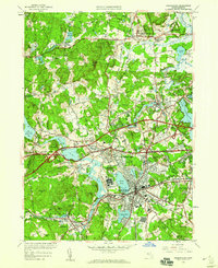
 1950 Hudson1958 Print · USGSMid-century Middlesex and Worcester counties come to life as the industrial Assabet River valley meets rural Bolton and Stow. Trace the Boston and Maine Railroad past Gleasondale Sta or find family roots at Old Quaker Cem and Bromfield Academy.3 unique versions available
 - 1950 Map of Framingham, 1959 Print
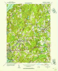
 1950 Framingham1959 Print · USGSMid-century Framingham and Sudbury are shown here during a decade of rapid expansion and highway development. Genealogists can locate family landmarks like Wayside Inn, Marys Lamb Sch, and Edgell Grove Cem among the growing suburban tracts.
 - 1953 Map of Shrewsbury, 1954 Print
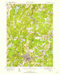
 1953 Shrewsbury1954 Print · USGSWorcester County during the mid-fifties shows a landscape of growing towns and significant public institutions between the Wachusett Reservoir and Northboro. Genealogists and researchers can locate the Grafton State Hospital, Pine Grove Cem, and the Lyman State Sch.3 unique versions available
 - 1953 Map of Marlboro, 1955 Print
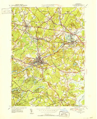
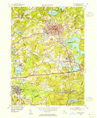 1953 Marlboro1955 Print · USGSMid-century Worcester County was a bustling corridor of industry and education at the height of the rail era. Researchers can trace family homesteads near Maplewood Cem or explore the institutional grounds of Westborough State Hospital and St Marks Sch.4 unique versions available
 - 1956 Map of Boston, 1967 Print
 1956 Boston1967 Print · USGSThe Massachusetts coastline and industrial interior are seen here during the mid-century peak of suburban and highway expansion. Researchers can trace historic harbor defenses like Fort Revere, local landmarks such as Faneuil Hall, and the vast Parker River National Wildlife Refuge.6 unique versions available
 - 1958 Map of Boston
 1958 Boston1958 Print · USGSEastern Massachusetts and southern New Hampshire are shown at the height of the industrial era, before the full expansion of the interstate system. Trace coastal defenses at Fort Warren, historic rail lines like the Boston and Maine, and the development of the Mass. 128 corridor.2 unique versions available
End of results
Showing maps 1-7 of 7
Top cities near Marlborough
- Worcester historical maps
- Framingham historical maps
- Leominster historical maps
- Fitchburg historical maps
- Billerica historical maps
- Chelmsford historical maps
See more
Top neighborhoods of Marlborough
Frequently asked questions
- What are the different types of historical maps available for Marlborough?
- What is the oldest map of Marlborough?
- Where can I purchase historical maps of Marlborough for my home or office?
- Where can I download high-res historical maps of Marlborough?
- Are there historical topographic maps available for Marlborough?
- Is there historical aerial imagery available for Marlborough?
- Where are historical maps of Marlborough sourced from?