1970s Maps of Marlborough, Massachusetts
Explore 5 historic maps of Marlborough from the 1970s. These maps offer a rare glimpse into what life looked like during the 1970s — showing old roads, neighborhoods, homes, and landmarks that have changed or disappeared over time.
Whether you're researching your family's past, planning a metal detecting trip, or studying how Marlborough's landscape evolved across the 1970s, these high-resolution maps are a powerful tool for exploring the history of this region.
- Focus on a specific era: All maps on this page are from the 1970s, giving you a focused view of this time period.
- See what’s changed: Compare century-old streets, trails, and buildings to today's modern landscape using overlays and satellite layers.
- Research with precision: Use these maps for genealogy, historical research, land use analysis, or educational projects.
- View, download, or print: Maps are fully viewable online in high resolution, and can be downloaded or printed for your own records.
Start exploring Marlborough's history through authentic maps from the 1970s. This is your window into the past.
Marlborough, MA maps
(5)- 1975 Map of Shrewsbury, 1981 Print
 1975 Shrewsbury1981 Print · USGSCentral Massachusetts suburbs undergo visible post-war transformation in the mid-seventies as seen through this detailed aerial survey. Trace the residential growth near Shrewsbury and Northborough or locate early development around Lake Quinsigamond.
 - 1977 Map of Hudson, 1981 Print
 1977 Hudson1981 Print · USGSMiddlesex County emerges from its agrarian past into a burgeoning suburban era in this late-seventies aerial study. Researchers can trace land development around the Assabet River or locate family sites in Hudson, Bolton, and Stow.
 - 1977 Map of Framingham, 1981 Print
 1977 Framingham1981 Print · USGSMiddlesex County emerges in high detail in the late seventies as suburban growth reshapes the landscape west of Boston. Trace the residential layout of Framingham and the industrial footprint near the Sudbury Reservoir and Ashland.
 - 1977 Map of Maynard, 1981 Print
 1977 Maynard1981 Print · USGSMiddlesex County enters the late seventies as a landscape of historic mill towns and growing residential corridors. Trace the development of Maynard and West Concord along the banks of the Assabet River.
 - 1977 Map of Marlborough, 1981 Print
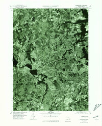
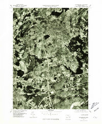 1977 Marlborough1981 Print · USGSMarlborough and the surrounding towns are shown during the late seventies as the region prepared for significant suburban growth. Researchers can trace the development of Marlborough and Westborough or study the shorelines of Sudbury Reservoir.
End of results
Showing maps 1-5 of 5
Top cities near Marlborough
- Worcester historical maps
- Framingham historical maps
- Leominster historical maps
- Fitchburg historical maps
- Billerica historical maps
- Chelmsford historical maps
See more
Top neighborhoods of Marlborough
Frequently asked questions
- What are the different types of historical maps available for Marlborough?
- What is the oldest map of Marlborough?
- Where can I purchase historical maps of Marlborough for my home or office?
- Where can I download high-res historical maps of Marlborough?
- Are there historical topographic maps available for Marlborough?
- Is there historical aerial imagery available for Marlborough?
- Where are historical maps of Marlborough sourced from?