1950s Maps of Nantucket, Massachusetts
Explore 6 historic maps of Nantucket from the 1950s. These maps offer a rare glimpse into what life looked like during the 1950s — showing old roads, neighborhoods, homes, and landmarks that have changed or disappeared over time.
Whether you're researching your family's past, planning a metal detecting trip, or studying how Nantucket's landscape evolved across the 1950s, these high-resolution maps are a powerful tool for exploring the history of this region.
- Focus on a specific era: All maps on this page are from the 1950s, giving you a focused view of this time period.
- See what’s changed: Compare century-old streets, trails, and buildings to today's modern landscape using overlays and satellite layers.
- Research with precision: Use these maps for genealogy, historical research, land use analysis, or educational projects.
- View, download, or print: Maps are fully viewable online in high resolution, and can be downloaded or printed for your own records.
Start exploring Nantucket's history through authentic maps from the 1950s. This is your window into the past.
Nantucket, MA maps
(6)- 1951 Map of Tuckernuck Island
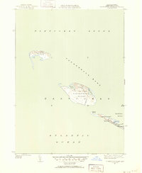 1951 Tuckernuck Island1951 Print · USGSNantucket's western outposts of Tuckernuck and Muskeget Islands are captured here in the early fifties, showing a landscape of shifting shoals and isolated ponds. Trace the old winding path of Smith Point Road or locate the solitary Tower on Muskeget Island.3 unique versions available
 - 1951 Map of Great Point
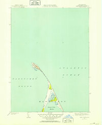 1951 Great Point1951 Print · USGSNantucket's northern reaches are captured here in the early fifties, showing the precarious coastal spit where the sound meets the sea. Coastal researchers can trace the mid-century shoreline at Great Point and the sheltered waters of Coskata Pond.4 unique versions available
 - 1951 Map of Siasconset
 1951 Siasconset1951 Print · USGSNantucket's eastern shore is captured in the early fifties as the island's maritime traditions met new aviation and navigation technology. Trace the Abandoned Railroad Grade into Siasconset or locate the old Coast Guard Loran Station near Tom Nevers Head.4 unique versions available
 - 1951 Map of Nantucket
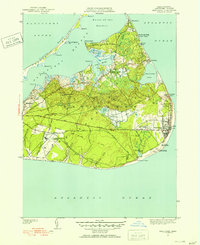
 1951 Nantucket1951 Print · USGSMid-century Nantucket Island comes to life here, showing the town's historic core and the wild western shore just after the war. Researchers can trace ancestral plots in Old North Cem, locate the Cyrus Peirce Sch, or explore the dunes near Eel Point.5 unique versions available
 - 1957 Map of Providence
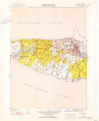
 1957 Providence1957 Print · USGSCoastal New England at the height of the mid-century era shows a landscape shaped by maritime industry and Cold War defense. Genealogists and historians can trace the reach of the New York, New Haven & Hartford RR and locate legacy sites like Fort Adams and Quonset Point Naval Air Station.
 - 1958 Map of Providence
 1958 Providence1958 Print · USGSThe Rhode Island and Massachusetts coastlines are shown in detail during the late 1950s, from the urban cores to the tips of the islands. Researchers can trace the mid-century footprint of Quonset Point Naval Air Station, the defense works at Fort Adams, and the rail network of the New York, New Haven and Hartford RR.
End of results
Showing maps 1-6 of 6
Top cities of Nantucket
Frequently asked questions
- What are the different types of historical maps available for Nantucket?
- What is the oldest map of Nantucket?
- Where can I purchase historical maps of Nantucket for my home or office?
- Where can I download high-res historical maps of Nantucket?
- Are there historical topographic maps available for Nantucket?
- Is there historical aerial imagery available for Nantucket?
- Where are historical maps of Nantucket sourced from?