1800s (19th Century) Maps of Nantucket, Massachusetts
Explore 6 historic maps of Nantucket from the 1800s (19th Century). These maps offer a rare glimpse into what life looked like during the 1800s — showing old roads, neighborhoods, homes, and landmarks that have changed or disappeared over time.
Whether you're researching your family's past, planning a metal detecting trip, or studying how Nantucket's landscape evolved across the 1800s, these high-resolution maps are a powerful tool for exploring the history of this region.
- Focus on a specific era: All maps on this page are from the 1800s, giving you a focused view of this time period.
- See what’s changed: Compare century-old streets, trails, and buildings to today's modern landscape using overlays and satellite layers.
- Research with precision: Use these maps for genealogy, historical research, land use analysis, or educational projects.
- View, download, or print: Maps are fully viewable online in high resolution, and can be downloaded or printed for your own records.
Start exploring Nantucket's history through authentic maps from the 1800s. This is your window into the past.
Nantucket, MA maps
(6)- 1887 Map of Muskeget
 1887 Muskeget1887 Print · USGSThe western reaches of Nantucket and its offshore islands are surveyed here in the late nineteenth century. Trace maritime history through landmarks like Maddaket Harbor, the isolated Muskeget Id., and the Cross Rip Shoal Light Ship.
 - 1889 Map of Muskeget
 1889 Muskeget1889 Print · USGSThe western reaches of Nantucket and its outlying islands are detailed here in the late nineteenth century. Maritime researchers can trace the intricate tidal channels of Maddequet Harbor and the isolated shorelines of Muskeget Id. and Tuckernuck Id..
 - 1889 Map of Nantucket
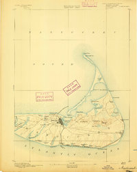
 1889 Nantucket1889 Print · USGSNantucket Island at the close of the 1880s reveals a maritime community before the automobile, connected by the narrow-gauge Nantucket Railroad. Genealogists and historians can trace old lineages through landmarks like Foulger's Hill and the remote outpost at Siasconsett.
 - 1893 Map of Nantucket
 1893 Nantucket1893 Print · USGSNantucket in the late Victorian era is captured here as a maritime and burgeoning resort community. Genealogists and historians can trace the early Nantucket Railroad route or locate the Life Saving Station and Sankaty Head Lt. along the shore.2 unique versions available
 - 1893 Map of Muskeget
 1893 Muskeget1893 Print · USGSNantucket's western islands and shoals are frozen in time during the late Victorian era. Maritime historians can trace the old coastal configuration of Tuckernuck Id. and its ponds, or explore the tidal creeks near Maddequet Harbor and Eel Point.
 - 1899 Map of Muskeget
 1899 Muskeget1899 Print · USGSNantucket's western reaches and isolated outer islands appear here in the late nineteenth century as maritime commerce relied on light ships and life-saving crews. Trace early coastal geography at Maddaket, the lonely L.S.S. on Muskeget Id., and the ponds of Tuckernuck Id.5 unique versions available
End of results
Showing maps 1-6 of 6
Top cities of Nantucket
Frequently asked questions
- What are the different types of historical maps available for Nantucket?
- What is the oldest map of Nantucket?
- Where can I purchase historical maps of Nantucket for my home or office?
- Where can I download high-res historical maps of Nantucket?
- Are there historical topographic maps available for Nantucket?
- Is there historical aerial imagery available for Nantucket?
- Where are historical maps of Nantucket sourced from?