1970s Maps of Nantucket, Massachusetts
Explore 8 historic maps of Nantucket from the 1970s. These maps offer a rare glimpse into what life looked like during the 1970s — showing old roads, neighborhoods, homes, and landmarks that have changed or disappeared over time.
Whether you're researching your family's past, planning a metal detecting trip, or studying how Nantucket's landscape evolved across the 1970s, these high-resolution maps are a powerful tool for exploring the history of this region.
- Focus on a specific era: All maps on this page are from the 1970s, giving you a focused view of this time period.
- See what’s changed: Compare century-old streets, trails, and buildings to today's modern landscape using overlays and satellite layers.
- Research with precision: Use these maps for genealogy, historical research, land use analysis, or educational projects.
- View, download, or print: Maps are fully viewable online in high resolution, and can be downloaded or printed for your own records.
Start exploring Nantucket's history through authentic maps from the 1970s. This is your window into the past.
Nantucket, MA maps
(8)- 1972 Map of Tuckernuck Island, 1973 Print
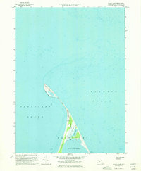
 1972 Tuckernuck Island1973 Print · USGSNantucket's western outposts are frozen in time during the early seventies, showing the shifting shoals of the sound. Trace the coastal landforms of Tuckernuck Island and Esther Island, including the Landing Strip and Madaket Harbor.3 unique versions available
 - 1972 Map of Nantucket, 1973 Print
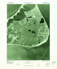
 1972 Nantucket1973 Print · USGSNantucket Island's coastal and village life is captured here in the early seventies, from the busy wharves to the quiet ponds of the interior. Researchers can trace historic family connections at the Old Settlers Graves, Brant Pt Lighthouse, and Academy Hill Sch.4 unique versions available
 - 1972 Map of Great Point, 1973 Print
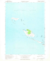
 1972 Great Point1973 Print · USGSNantucket Island's northern tip is captured in the early seventies, showing a landscape shaped by shifting sands and maritime history. Trace the solitary Jeep Trail leading past Coskata Pond to the iconic Lighthouse at Great Point.3 unique versions available
 - 1972 Map of Siasconset, 1973 Print
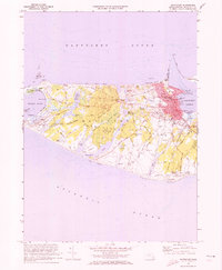
 1972 Siasconset1973 Print · USGSNantucket's eastern shore comes to life in the early seventies, showing the transition from historic maritime hamlets to modern island infrastructure. Trace the Old Railroad Grade, locate the Sankaty Head lighthouse, and explore the interior bogs near Gibbs Pond.5 unique versions available
 - 1977 Map of Nantucket, 1981 Print
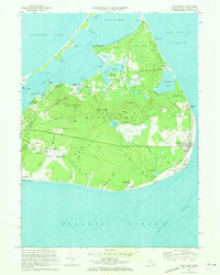
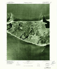 1977 Nantucket1981 Print · USGSNantucket Island in the late 1970s is shown here through detailed aerial photography, offering a literal view of the coastal landscape and town. Researchers can trace development patterns from the harbor at Nantucket to the outposts of Madaket and Surfside.
 - 1977 Map of Tuckernuck Island, 1981 Print
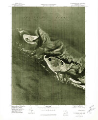 1977 Tuckernuck Island1981 Print · USGSTuckernuck and Muskeget Islands appear in their late-seventies coastal state in this detailed aerial survey. Researchers can examine the shifting sands of Esther Island and the shoreline at Madaket before decades of North Atlantic storms.
 - 1977 Map of Great Point, 1981 Print
 1977 Great Point1981 Print · USGSThe northern reaches of Nantucket are captured in this late-seventies aerial survey during a period of relative coastal stability. Researchers can examine the shoreline and sand structures near Coskata, Wauwinet, and the tip of Great Point.
 - 1977 Map of Siasconset, 1981 Print
 1977 Siasconset1981 Print · USGSThe eastern side of Nantucket is shown in the late 1970s through detailed aerial orthophotography. Researchers can trace the layout of coastal settlements like Siasconset, Quidnet, and Wauwinet during this period of island development.
End of results
Showing maps 1-8 of 8
Top cities of Nantucket
Frequently asked questions
- What are the different types of historical maps available for Nantucket?
- What is the oldest map of Nantucket?
- Where can I purchase historical maps of Nantucket for my home or office?
- Where can I download high-res historical maps of Nantucket?
- Are there historical topographic maps available for Nantucket?
- Is there historical aerial imagery available for Nantucket?
- Where are historical maps of Nantucket sourced from?