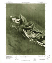
1977 Map of Tuckernuck Island
USGS Topo · Published 1981About this map
Tuckernuck Island and the neighboring Muskeget Island are captured in this 1977 orthophotoquad, showing the shifting coastal geomorphology of the archipelago west of Nantucket Island. The aerial imagery reveals the intricate patterns of shoals and sandbars that characterize the waters between Nantucket Sound and the open Atlantic Ocean. This specific moment in the late 1970s documents the isolation of Esther Island and the western edge of the main island at Madaket. Produced by the Geological Survey and the Massachusetts Department of Public Works, the map emphasizes the natural state of these low-lying landmasses, where the absence of dense development highlights the ongoing environmental processes of erosion and deposition that define the Massachusetts coastline.
Find a feature on this map
7 named features on this map. Tap any name to fly to it.
Don’t see what you’re looking for? This feature index may not catch every label — zoom into the map to look around manually.
Map Details
Editions of this 1977 Tuckernuck Island Map
This is the sole edition of this map. No revisions or reprints were ever made.
Other maps of this area

1887 · Muskeget
USGS Topo · 1:62,500

1889 · Muskeget
USGS Topo · 1:62,500

1893 · Muskeget
USGS Topo · 1:62,500

1899 · Muskeget
USGS Topo · 1:62,500

1942 · Nantucket
USGS Topo · 1:125,000

1944 · Tuckernuck Island
USGS Topo · 1:31,680

1945 · Nantucket
USGS Topo · 1:31,680

1947 · Providence
USGS Topo · 1:250,000

1948 · Providence
USGS Topo · 1:250,000
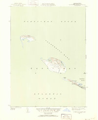
1951 · Tuckernuck Island
USGS Topo · 1:31,680