1940s Maps of Nantucket, Massachusetts
Explore 7 historic maps of Nantucket from the 1940s. These maps offer a rare glimpse into what life looked like during the 1940s — showing old roads, neighborhoods, homes, and landmarks that have changed or disappeared over time.
Whether you're researching your family's past, planning a metal detecting trip, or studying how Nantucket's landscape evolved across the 1940s, these high-resolution maps are a powerful tool for exploring the history of this region.
- Focus on a specific era: All maps on this page are from the 1940s, giving you a focused view of this time period.
- See what’s changed: Compare century-old streets, trails, and buildings to today's modern landscape using overlays and satellite layers.
- Research with precision: Use these maps for genealogy, historical research, land use analysis, or educational projects.
- View, download, or print: Maps are fully viewable online in high resolution, and can be downloaded or printed for your own records.
Start exploring Nantucket's history through authentic maps from the 1940s. This is your window into the past.
Nantucket, MA maps
(7)- 1942 Map of Nantucket, 1943 Print
 1942 Nantucket1943 Print · USGSNantucket and Chappaquiddick Islands are captured here during the early years of the Second World War. Genealogists and historians can trace the early roads to Siasconset, the Steamship Ferry route, and the locations of Madd Aket LSS and Coskata LSS.
 - 1944 Map of Tuckernuck Island
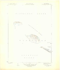 1944 Tuckernuck Island1944 Print · USGSThe isolated outposts of Nantucket Sound are captured here during the 1940s, showing the fragile geography of Tuckernuck Island and Muskeget Island. Researchers can trace the old path of Smith Point Road and the coastal contours of Maddeket Harbor.3 unique versions available
 - 1945 Map of Nantucket
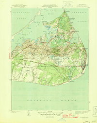
 1945 Nantucket1945 Print · USGSNantucket during the mid-forties reveals a coastal landscape of tight-knit town streets and sprawling marshlands. Genealogists and historians can trace old property lines and landmarks from Old North Cem to the outskirts of Maddaket and Surfside.2 unique versions available
 - 1945 Map of Siasconset
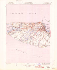
 1945 Siasconset1945 Print · USGSNantucket's eastern shore and interior moors are captured here in the mid-1940s, documenting the island's road and rail history. Trace the Abandoned Railroad Grade past the large Cranberry Bog to the coastal village of Siasconset.2 unique versions available
 - 1945 Map of Great Point
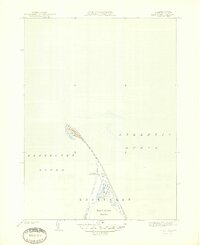 1945 Great Point1945 Print · USGSThe northern tip of Nantucket is captured during the mid-1940s, showing the slender barrier beaches of Great Point. Researchers can locate maritime landmarks like the Coskata C G Station and the secluded Coskata Pond.2 unique versions available
 - 1947 Map of Providence, 1948 Print
 1947 Providence1948 Print · USGSSouthern New England is captured in the mid-1940s, showing a landscape defined by busy industrial ports and expanding military installations. Researchers can trace the rail lines of the N.Y. N.H. & H. RR or locate coastal defenses like Fort Adams and Quonset Point.5 unique versions available
 - 1948 Map of Providence, 1951 Print
 1948 Providence1951 Print · USGSSouthern New England’s coastal reaches are captured here in the late 1940s, from the industrial heart of Providence to the tip of Provincetown. Genealogists and historians can trace rail lines like the Central Vermont Railway and locate active military sites such as Otis Air Force Base and Fort Rodman.
End of results
Showing maps 1-7 of 7
Top cities of Nantucket
Frequently asked questions
- What are the different types of historical maps available for Nantucket?
- What is the oldest map of Nantucket?
- Where can I purchase historical maps of Nantucket for my home or office?
- Where can I download high-res historical maps of Nantucket?
- Are there historical topographic maps available for Nantucket?
- Is there historical aerial imagery available for Nantucket?
- Where are historical maps of Nantucket sourced from?