1940s Maps of Norfolk County, Massachusetts
Explore 48 historic maps of Norfolk County from the 1940s. These maps offer a rare glimpse into what life looked like during the 1940s — showing old roads, neighborhoods, homes, and landmarks that have changed or disappeared over time.
Whether you're researching your family's past, planning a metal detecting trip, or studying how Norfolk County's landscape evolved across the 1940s, these high-resolution maps are a powerful tool for exploring the history of this region.
- Focus on a specific era: All maps on this page are from the 1940s, giving you a focused view of this time period.
- See what’s changed: Compare century-old streets, trails, and buildings to today's modern landscape using overlays and satellite layers.
- Research with precision: Use these maps for genealogy, historical research, land use analysis, or educational projects.
- View, download, or print: Maps are fully viewable online in high resolution, and can be downloaded or printed for your own records.
Start exploring Norfolk County's history through authentic maps from the 1940s. This is your window into the past.
Norfolk County, MA maps
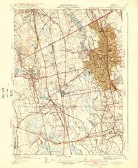
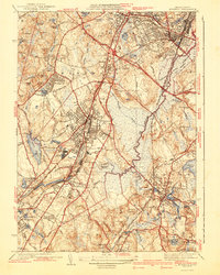
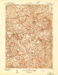
(48)- 1940 Map of Franklin
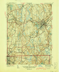 1940 Franklin1940 Print · USGSFranklin and the surrounding border towns of Norfolk County are shown here just before the mid-century. Genealogists can locate specific sites like Dean Academy, St Johns Cem, and the old rail corridors of the New York New Haven and Hartford.2 unique versions available
 - 1940 Map of Wrentham
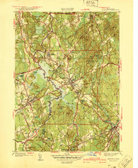
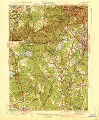
 1940 Wrentham1940 Print · USGSNorfolk County in the late 1930s shows a landscape of busy mill villages and expanding state institutions. Genealogists can trace family roots through the Bacon Cem, Quaker Cem, and local schools like Vogel Sch and Everett Sch.2 unique versions available
 - 1940 Map of Medfield
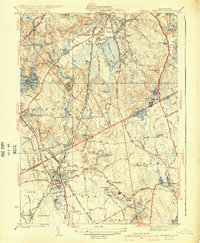
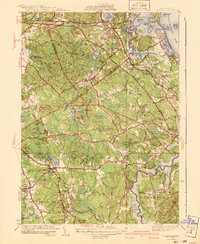
 1940 Medfield1940 Print · USGSMedfield and the surrounding Charles River valley appear here just before the Second World War, showing a landscape of small villages and large institutional grounds. Researchers can trace the old rail beds of the New York New Haven and Hartford and find local landmarks like Schoolhouse No 14 and the Medfield State Hospital.2 unique versions available
 - 1941 Map of Holliston
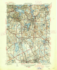
 1941 Holliston1941 Print · USGSThe town of Holliston and the surrounding river valleys are captured here just before the mid-century suburban expansion. Genealogists and historians can trace rail-era landmarks like Braggville Sta, local institutions like the Wilder Sch, and old burial grounds including Lake Grove Cem.
 - 1941 Map of Mansfield
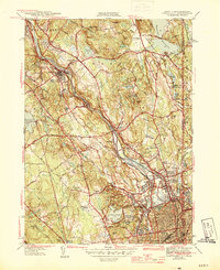
 1941 Mansfield1941 Print · USGSThe Norfolk and Bristol county borderlands are shown here just before the mid-century suburban boom, centered on the New York New Haven and Hartford rail corridor. Genealogists and historians can locate old rural corners like Ginty Corner and school sites such as the Poquanticut Sch.3 unique versions available
 - 1941 Map of Weymouth
 1941 Weymouth1941 Print · USGSThe South Shore and its bustling maritime industry are on full display in the years leading up to the second World War. Genealogists can locate family sites like the Old South Meeting House or trace industrial roots at the Fore River Shipyard and Plymouth Quarries.3 unique versions available
 - 1941 Map of Brockton
 1941 Brockton1941 Print · USGSSoutheastern Massachusetts is captured here in the early 1940s, showing the dense rail-centered growth of the region. Researchers can trace historic family landmarks and institutional sites like the Howard Seminary, St Patrick Cem, and Easton Sta.3 unique versions available
 - 1941 Map of Blue Hills
 1941 Blue Hills1941 Print · USGSThe Blue Hills south of Boston are shown here at the edge of the pre-war era, before massive highway expansion reshaped Norfolk County. Genealogists and historians can trace the grounds of Thayer Academy, the Blue Hills Cem, and the industrial Fireworks site.4 unique versions available
 - 1941 Map of Cohasset
 1941 Cohasset1941 Print · USGSCoastal Plymouth County in the mid-1930s reveals a landscape of tidal harbors, granite hills, and rail-side villages. Genealogists and local historians can trace family-named sites like Kings Landing, the Curtis Sch, and the Old Oaken Bucket Homestead Road.3 unique versions available
 - 1941 Map of Nantasket
 1941 Nantasket1941 Print · USGSCoastal Plymouth County in the years before the war shows a landscape defined by maritime heritage and seaside growth. Researchers can trace the development of Kenberma, locate the old Patriot Sch, and study the offshore positions of The Graves and the Boston Lightship.3 unique versions available
 - 1941 Map of Norwood
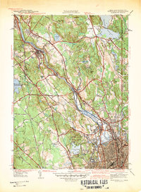
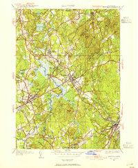
 1941 Norwood1941 Print · USGSNorfolk County during the mid-1930s shows a landscape of growing town centers and industrial rail corridors along the Neponset River. Researchers can trace local landmarks like the Sharon Sanitorium, Highland Cem, and the specialized Norfolk County Agricultural Sch.3 unique versions available
 - 1942 Map of Holliston
 1942 Holliston1942 Print · USGSHolliston and the surrounding river valleys of Middlesex and Norfolk counties are captured here just before the mid-century suburban shift. Genealogists can locate family landmarks like the Wilder Sch, St Marys Cem, and the historic Braggville Sta along the rail lines.2 unique versions available
 - 1942 Map of Pawtucket
 1942 Pawtucket1942 Print · USGSThe Blackstone River valley thrives at the start of the 1940s, showcasing a landscape defined by mill towns and extensive rail infrastructure. Researchers can trace the heritage of local communities through landmarks like the Cistercian Monastery, Lonsdale Sta, and the Moshassuck Cem.
 - 1943 Map of Providence
 1943 Providence1943 Print · USGSNarragansett Bay and the industrial Blackstone Valley appear here in the midst of the Second World War. Genealogists and researchers can trace local landmarks like Lonsdale Station, the St Marys Reservoir, and the Rhode Island State Airport.
 - 1943 Map of Boston
 1943 Boston1943 Print · USGSGreater Boston and its southern suburbs appear here during the mobilization of the early 1940s. Genealogists and historians can trace the early footprints of Commonwealth Airport, military sites like Fort Winthrop, and local institutions such as Pondville State Hospital.
 - 1943 Map of Attleboro
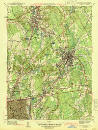 1943 Attleboro1943 Print · USGSAttleboro and its surrounding mill villages are captured here during the Second World War era. Researchers can trace ancestral roots through sites like the Old Town Hall, Newell Cem, and the specialized Attleboro Springs Sanitarium.3 unique versions available
 - 1943 Map of Quinsigamond
 1943 Quinsigamond1943 Print · USGSCentral Massachusetts and its bordering states appear here during the Second World War as a powerhouse of rail infrastructure and public institutions. Researchers can trace the legacy of the region through landmarks like Grafton State Hospital, the Wachusett Reservoir, and the deep industrial roots of the Blackstone River.
 - 1943 Map of Natick
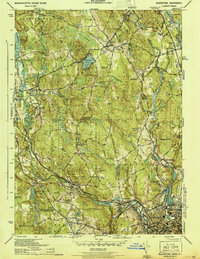
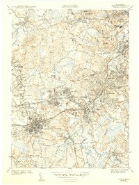 1943 Natick1943 Print · USGSMiddlesex and Norfolk Counties are shown here during the early 1940s as suburban growth began to surround historic town centers. Researchers can trace family sites near Wellesley College, find old burials at South Cem, and follow the Boston and Maine rail lines.5 unique versions available
 - 1944 Map of Newton
 1944 Newton1944 Print · USGSThe western suburbs of Boston thrive in the mid-1940s, defined by the winding Charles River and a dense network of rail lines. Genealogists and local historians can trace family plots and parish boundaries at Newton Cem, St Gabriels Monastery, and the Christian Science Sanatorium.
 - 1944 Map of Pawtucket
 1944 Pawtucket1944 Print · USGSThe industrial corridor of the Blackstone River valley is frozen in time during the mid-1940s, showing the dense rail networks and mill towns of northern Rhode Island. Genealogists and historians can trace family roots through the Moshassuck Cem, find local schools like Garvin Sch, and locate the Cistercian Monastery.3 unique versions available
 - 1944 Map of Hull
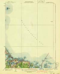
 1944 Hull1944 Print · USGSCoastal Massachusetts at the height of the Second World War is captured here through the harbor's intricate islands and shorelines. Genealogists and maritime historians can trace residential roots in Houghs Neck or study military sites like Ft Andrews and Ft Duvall.
 - 1944 Map of Blackstone
 1944 Blackstone1944 Print · USGSThe Blackstone River valley during the mid-forties shows a bustling landscape of industrial mill towns and upland farms along the state line. Genealogists can locate family landmarks like the Chestnut Hill Meeting House, Bicknell Cem, and the Elmdale Sch.5 unique versions available
 - 1944 Map of Boston South
 1944 Boston South1944 Print · USGSBoston and its southern neighbors show a dense mid-century network of colleges and coastlines during the 1940s. Trace local roots at Forest Hills Cem, find early campus layouts for Harvard University, or explore the maritime bustle at South Boston and the US Naval Reservation.
 - 1945 Map of Medfield, 1954 Print
 1945 Medfield1954 Print · USGSThe Charles River valley and its rail-connected towns appear here during the mid-forties. Genealogists and historians can trace family locations near Medfield State Hospital, Farm St Sta, and Vine Lake Cem.3 unique versions available
 - 1945 Map of Franklin, 1956 Print
 1945 Franklin1956 Print · USGSFranklin and the surrounding borderlands of Massachusetts and Rhode Island are captured here during a period of steady post-war growth. Researchers can trace historic family landmarks such as Ballow Meetinghouse, Dean Academy, and the St Johns Cem.
Showing maps 1-25 of 48
Top cities of Norfolk County
- Quincy historical maps
- Brookline historical maps
- Weymouth historical maps
- Braintree historical maps
- Randolph historical maps
- Franklin historical maps
See more
Frequently asked questions
- What are the different types of historical maps available for Norfolk County?
- What is the oldest map of Norfolk County?
- Where can I purchase historical maps of Norfolk County for my home or office?
- Where can I download high-res historical maps of Norfolk County?
- Are there historical topographic maps available for Norfolk County?
- Is there historical aerial imagery available for Norfolk County?
- Where are historical maps of Norfolk County sourced from?