1960s Maps of Norfolk County, Massachusetts
Explore 12 historic maps of Norfolk County from the 1960s. These maps offer a rare glimpse into what life looked like during the 1960s — showing old roads, neighborhoods, homes, and landmarks that have changed or disappeared over time.
Whether you're researching your family's past, planning a metal detecting trip, or studying how Norfolk County's landscape evolved across the 1960s, these high-resolution maps are a powerful tool for exploring the history of this region.
- Focus on a specific era: All maps on this page are from the 1960s, giving you a focused view of this time period.
- See what’s changed: Compare century-old streets, trails, and buildings to today's modern landscape using overlays and satellite layers.
- Research with precision: Use these maps for genealogy, historical research, land use analysis, or educational projects.
- View, download, or print: Maps are fully viewable online in high resolution, and can be downloaded or printed for your own records.
Start exploring Norfolk County's history through authentic maps from the 1960s. This is your window into the past.
Norfolk County, MA maps
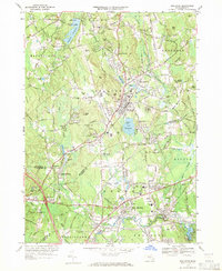
(12)- 1961 Map of Boston
 1961 Boston1961 Print · USGSThe Massachusetts coastline and its industrial interior are detailed here in the mid-twentieth century, from the Monadnock highlands to Cape Cod. Researchers can trace the rail routes of the Boston and Maine or locate landmarks like Fort Devens and the Wachusett Reservoir.2 unique versions available
 - 1961 Map of Cohasset, 1963 Print
 1961 Cohasset1963 Print · USGSThe South Shore at the start of the sixties reveals a blend of coastal heritage and postwar growth. Local historians can trace family roots through the Old First Parish Cem or locate historic sites like Kings Landing and the Old Oaken Bucket Homestead.2 unique versions available
 - 1961 Map of Nantasket, 1963 Print
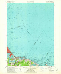 1961 Nantasket1963 Print · USGSThe Massachusetts coastline in the early sixties shows the vibrant seaside life and maritime hazards of the South Shore. Genealogists and local historians can trace family properties near Paragon Park, North Cohasset, and the historic Boston Light.2 unique versions available
 - 1963 Map of Providence
 1963 Providence1963 Print · USGSSouthern New England's coastal and industrial heartland is captured here in the early sixties, from the Rhode Island mainland to the far reaches of the Cape. Researchers can trace mid-century growth in Providence or locate landmarks on Marthas Vineyard and Nantucket Island.
 - 1963 Map of Brockton, 1965 Print
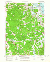
 1963 Brockton1965 Print · USGSBrockton and the surrounding Plymouth County townships are shown here during a mid-century period of growth and expansion. Genealogists and local historians can trace family roots through numerous named junctions and sites like Pratts Corner, Easton Sta, and Melrose Cemetery.
 - 1964 Map of Franklin, 1965 Print
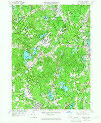
 1964 Franklin1965 Print · USGSThe borderlands of Massachusetts and Rhode Island are shown in the mid-1960s as suburban growth met traditional industry. Trace family sites like Ballou Cem, find old neighborhood names like Sheldonville, or locate the Dean Jr College campus.4 unique versions available
 - 1964 Map of Wrentham, 1966 Print
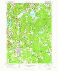
 1964 Wrentham1966 Print · USGSMid-century Norfolk and Bristol counties are shown here as a landscape of state institutions, growing suburban fringes, and deep swamps. Researchers can locate family landmarks like the Quaker Cem, or trace the New Haven and Hartford RR through Wrentham and Plainville.2 unique versions available
 - 1964 Map of Mansfield, 1966 Print
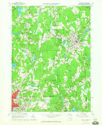
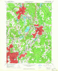
 1964 Mansfield1966 Print · USGSSoutheastern Massachusetts in the mid-1960s shows a landscape of historic mill villages and suburban growth along the New York New Haven and Hartford rail line. Researchers can trace local heritage through landmarks like Massapoag Lake, King Philips Rock, and the old postal center at Furnace Village.3 unique versions available
 - 1964 Map of Attleboro, 1966 Print
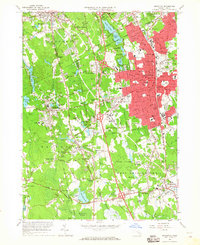
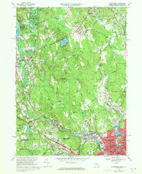
 1964 Attleboro1966 Print · USGSThe Attleboro area and the Rhode Island borderlands are shown here in the mid-1960s, a period of established industrial and institutional growth. Genealogists can trace family sites at Mount Hope Cem or North Purchase Cem, and explore schools like Bishop Feehan High Sch.4 unique versions available
 - 1965 Map of Franklin, 1979 Print
 1965 Franklin1979 Print · USGSThe Massachusetts and Rhode Island border country comes into focus in the mid-twentieth century, showing the growing suburbs around Bellingham and Unionville. Genealogists and historians can trace family plots at Ballou Cem and locate institutional landmarks like Dean Junior College and St Marys Abbey.
 - 1969 Map of Blackstone, 1971 Print
 1969 Blackstone1971 Print · USGSThe Blackstone River valley comes alive in the late sixties, showing the industrial heart of the Massachusetts and Rhode Island border. Researchers can trace ancestral roots through dozens of local sites, from the Chestnut Hill Meeting House Cem to the storied streets of Woonsocket and Millville.6 unique versions available
 - 1969 Map of Holliston, 1971 Print
 1969 Holliston1971 Print · USGSMiddlesex and Norfolk Counties come into focus during this era of suburban refinement and established rail transit. Genealogists and local historians can trace family plots and early landmarks at Indian Cem, Braggville Station, and West Medway.2 unique versions available
End of results
Showing maps 1-12 of 12
Top cities of Norfolk County
- Quincy historical maps
- Brookline historical maps
- Weymouth historical maps
- Braintree historical maps
- Randolph historical maps
- Franklin historical maps
See more
Frequently asked questions
- What are the different types of historical maps available for Norfolk County?
- What is the oldest map of Norfolk County?
- Where can I purchase historical maps of Norfolk County for my home or office?
- Where can I download high-res historical maps of Norfolk County?
- Are there historical topographic maps available for Norfolk County?
- Is there historical aerial imagery available for Norfolk County?
- Where are historical maps of Norfolk County sourced from?