1990s Maps of Norfolk County, Massachusetts
Explore 2 historic maps of Norfolk County from the 1990s. These maps offer a rare glimpse into what life looked like during the 1990s — showing old roads, neighborhoods, homes, and landmarks that have changed or disappeared over time.
Whether you're researching your family's past, planning a metal detecting trip, or studying how Norfolk County's landscape evolved across the 1990s, these high-resolution maps are a powerful tool for exploring the history of this region.
- Focus on a specific era: All maps on this page are from the 1990s, giving you a focused view of this time period.
- See what’s changed: Compare century-old streets, trails, and buildings to today's modern landscape using overlays and satellite layers.
- Research with precision: Use these maps for genealogy, historical research, land use analysis, or educational projects.
- View, download, or print: Maps are fully viewable online in high resolution, and can be downloaded or printed for your own records.
Start exploring Norfolk County's history through authentic maps from the 1990s. This is your window into the past.
Norfolk County, MA maps
(2)- 1997 Map of Hull, 1999 Print
 1997 Hull1999 Print · USGSThe Hull peninsula and Boston's outer harbor islands are shown here in detail during the late 1990s. Genealogists and local historians can trace coastal neighborhoods from Allerton to Kenberma, or locate historic maritime defenses like Fort Warren and Fort Standish.
 - 1998 Map of Pawtucket, 2000 Print
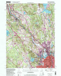 1998 Pawtucket2000 Print · USGSNorthern Rhode Island's industrial heartland is captured here at the end of the millennium as it borders Massachusetts. Researchers can trace the Blackstone River mill towns, from Central Falls to Arnold Mills, and locate family sites at Polish Cem or Sayles Hill Cem.
End of results
Showing maps 1-2 of 2
Top cities of Norfolk County
- Quincy historical maps
- Brookline historical maps
- Weymouth historical maps
- Braintree historical maps
- Randolph historical maps
- Franklin historical maps
See more
Frequently asked questions
- What are the different types of historical maps available for Norfolk County?
- What is the oldest map of Norfolk County?
- Where can I purchase historical maps of Norfolk County for my home or office?
- Where can I download high-res historical maps of Norfolk County?
- Are there historical topographic maps available for Norfolk County?
- Is there historical aerial imagery available for Norfolk County?
- Where are historical maps of Norfolk County sourced from?