1940s Maps of Marshfield, Massachusetts
Explore 9 historic maps of Marshfield from the 1940s. These maps offer a rare glimpse into what life looked like during the 1940s — showing old roads, neighborhoods, homes, and landmarks that have changed or disappeared over time.
Whether you're researching your family's past, planning a metal detecting trip, or studying how Marshfield's landscape evolved across the 1940s, these high-resolution maps are a powerful tool for exploring the history of this region.
- Focus on a specific era: All maps on this page are from the 1940s, giving you a focused view of this time period.
- See what’s changed: Compare century-old streets, trails, and buildings to today's modern landscape using overlays and satellite layers.
- Research with precision: Use these maps for genealogy, historical research, land use analysis, or educational projects.
- View, download, or print: Maps are fully viewable online in high resolution, and can be downloaded or printed for your own records.
Start exploring Marshfield's history through authentic maps from the 1940s. This is your window into the past.
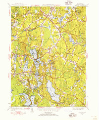
Marshfield, MA maps
(9)- 1940 Map of Scituate
 1940 Scituate1940 Print · USGSThe Plymouth County coast is captured in the late 1930s, documenting a landscape of seaside villages and tidal rivers. Researchers can trace the path of the New York New Haven and Hartford RR and find local landmarks like Union Cem and Fourth Cliff.4 unique versions available
 - 1940 Map of Hanover
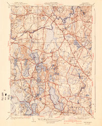 1940 Hanover1940 Print · USGSThe pond-strewn landscape of Plymouth County is captured here in the years before mid-century suburbanization. You can trace early schoolhouse locations like the Smith Sch, find ancestral plots in the Pine Grove Cem, and follow the old line of the New York New Haven and Hartford RR.3 unique versions available
 - 1941 Map of Duxbury
 1941 Duxbury1941 Print · USGSCoastal Massachusetts at the start of the 1940s reveals a landscape rich in Pilgrim history and maritime tradition. Genealogists and historians can locate the Grave of Myles Standish, the John Alden House, and the Standish Monument.3 unique versions available
 - 1941 Map of Cohasset
 1941 Cohasset1941 Print · USGSCoastal Plymouth County in the mid-1930s reveals a landscape of tidal harbors, granite hills, and rail-side villages. Genealogists and local historians can trace family-named sites like Kings Landing, the Curtis Sch, and the Old Oaken Bucket Homestead Road.3 unique versions available
 - 1947 Map of Scituate, 1958 Print
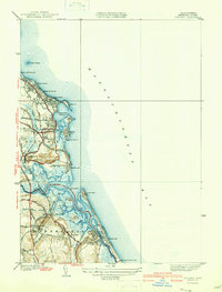
 1947 Scituate1958 Print · USGSCoastal Plymouth County in the late 1940s reveals a landscape of tidal marshes and seaside villages. Genealogists and historians can trace the early layout of Scituate Harbor, the New York New Haven and Hartford rail line, and local landmarks like Union Cem.
 - 1947 Map of Cohasset, 1958 Print
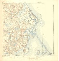
 1947 Cohasset1958 Print · USGSThe Massachusetts South Shore is captured here in the late 1940s, balancing its historic seafaring roots with early postwar growth. Researchers can trace family sites from Assinippi to North Scituate, including landmarks like Lawson Tower and the Old Oaken Bucket Homestead.
 - 1947 Map of Duxbury, 1958 Print
 1947 Duxbury1958 Print · USGSCoastal Massachusetts is captured here in the late 1940s, showing a landscape defined by colonial heritage and maritime industry. Genealogists and historians can locate significant family sites like the John Alden House, Mayflower Cem, and the Daniel Webster House.
 - 1948 Map of Boston
 1948 Boston1948 Print · USGSEastern Massachusetts and southern New Hampshire appear at an industrial peak in the late 1940s, just as suburban growth began to accelerate. Genealogists and historians can trace rail lines like the Boston and Albany RR or locate coastal landmarks like Graves Lighthouse and Fort Devens.2 unique versions available
 - 1948 Map of Hanover, 1956 Print
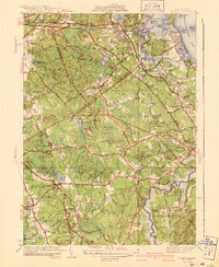
 1948 Hanover1956 Print · USGSMid-century Plymouth County is captured here at a time when the rail-and-river economy still shaped life in Hanover and Pembroke. Genealogists can locate family sites near Lady of the Lake Ch, Fern Hill Cem, or the old Thomas Sch.2 unique versions available
End of results
Showing maps 1-9 of 9
Top cities near Marshfield
- Boston historical maps
- Plymouth historical maps
- Weymouth historical maps
- Bridgewater historical maps
- Hingham historical maps
- Pembroke historical maps
See more
Top neighborhoods of Marshfield
- Green Harbor historical maps
- Kent Park historical maps
- Little Bridge historical maps
- Marshfield Hills historical maps
- Ferry Hill historical maps
- North Marshfield historical maps
See more
Frequently asked questions
- What are the different types of historical maps available for Marshfield?
- What is the oldest map of Marshfield?
- Where can I purchase historical maps of Marshfield for my home or office?
- Where can I download high-res historical maps of Marshfield?
- Are there historical topographic maps available for Marshfield?
- Is there historical aerial imagery available for Marshfield?
- Where are historical maps of Marshfield sourced from?