1900s (20th Century) Maps of Charlton, Massachusetts
Explore 41 historic maps of Charlton from the 1900s (20th Century). These maps offer a rare glimpse into what life looked like during the 1900s — showing old roads, neighborhoods, homes, and landmarks that have changed or disappeared over time.
Whether you're researching your family's past, planning a metal detecting trip, or studying how Charlton's landscape evolved across the 1900s, these high-resolution maps are a powerful tool for exploring the history of this region.
- Focus on a specific era: All maps on this page are from the 1900s, giving you a focused view of this time period.
- See what’s changed: Compare century-old streets, trails, and buildings to today's modern landscape using overlays and satellite layers.
- Research with precision: Use these maps for genealogy, historical research, land use analysis, or educational projects.
- View, download, or print: Maps are fully viewable online in high resolution, and can be downloaded or printed for your own records.
Start exploring Charlton's history through authentic maps from the 1900s. This is your window into the past.
Charlton, MA maps
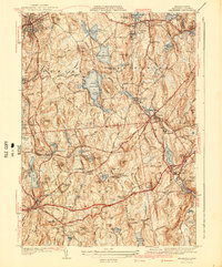
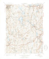
(41)- 1908 Map of Quinsigamond
 1908 Quinsigamond1908 Print · USGSCentral Massachusetts and its bordering states are seen here in the early twentieth century as industry and transit reshaped the Blackstone Valley. Genealogists and historians can trace the early footprints of Worcester, the expansion of the Wachusett Reservoir, and rail lines like the Boston and Albany Railroad.3 unique versions available
 - 1908 Map of Ware
 1908 Ware1908 Print · USGSCentral Massachusetts at the turn of the century reveals the Swift River Valley decades before the Quabbin Reservoir changed the landscape forever. Trace the lost footprints of Enfield and Dana, or follow the Central Vermont RR through Greenwich Village and Ware.2 unique versions available
 - 1915 Map of Brookfield
 1915 Brookfield1915 Print · USGSCentral Massachusetts and the Connecticut border are captured in the final months of the pre-war era, showing a dense network of textile villages and rail lines. Genealogists and local historians can trace the growth of Southbridge or locate landmarks like the Electric Power Relay Station and Lead Mine Mountain.
 - 1921 Map of Brookfield
 1921 Brookfield1921 Print · USGSMassachusetts and Connecticut borderlands appear here in the early twentieth century as a complex landscape of hill farms, industrial villages, and rail corridors. Genealogists can locate family landmarks like Foster Hill or trace the early industrial footprint of Leadmine and the Boston and Albany Railroad.
 - 1921 Map of Webster
 1921 Webster1921 Print · USGSThe industrial valleys and hill towns of southern Worcester County are seen here just after the Great War. Genealogists can trace the rail-centered growth of Webster and Auburn Sta. or locate old village centers like Cherry Valley and Rochdale.
 - 1937 Map of Leicester
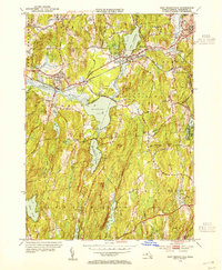
 1937 Leicester1937 Print · USGSWorcester County's industrial villages and highland farms are captured in detail just before the late-century expansion. Genealogists can trace family sites like the Clark Barton Home, Gore Cem, and the specialized Charlton Home Farm.
 - 1941 Map of Leicester
 1941 Leicester1941 Print · USGSCentral Massachusetts in the late 1930s reveals a network of mill ponds and historic settlements between Spencer and Auburn. Genealogists can locate family sites near the Clara Barton Home, Pine Grove Cem, and the Masonic Home.2 unique versions available
 - 1942 Map of Ware
 1942 Ware1942 Print · USGSCentral Massachusetts and the Connecticut border are captured here during the early years of the war, just as the landscape was being reshaped by the Quabbin Reservoir. Researchers can trace rail-era industry and local landmarks like the Lead Mine and the Bald Peak Hospital.
 - 1943 Map of Brookfield
 1943 Brookfield1943 Print · USGSCentral Massachusetts at the height of the war era shows a landscape of busy rail towns and upland ponds. Genealogists and historians can trace family-named peaks like Coys Hill and old industry along the Boston and Albany RR or near Southbridge.
 - 1943 Map of Quinsigamond
 1943 Quinsigamond1943 Print · USGSCentral Massachusetts and its bordering states appear here during the Second World War as a powerhouse of rail infrastructure and public institutions. Researchers can trace the legacy of the region through landmarks like Grafton State Hospital, the Wachusett Reservoir, and the deep industrial roots of the Blackstone River.
 - 1945 Map of Southbridge
 1945 Southbridge1945 Print · USGSSouth-central Massachusetts and northern Connecticut are captured here during the mid-forties, centered on the industrial corridor of the Quinebaug River. Genealogists and local researchers can trace family plots at Oak Ridge Cem or locate old community sites like Globe Village and Fiskdale.2 unique versions available
 - 1945 Map of Webster
 1945 Webster1945 Print · USGSThe borderlands of Massachusetts and Connecticut come alive in this mid-century survey of a thriving industrial river valley. Researchers can trace the heritage of mill towns and educational landmarks like Nichols College, West Dudley, and Perryville.2 unique versions available
 - 1946 Map of East Brookfield
 1946 East Brookfield1946 Print · USGSCentral Massachusetts in the late 1940s reveals a region of interconnected mill towns and expansive glacial lakes. You can trace the path of the Boston and Albany RR through East Brookfield or locate family sites near Podunk Cem and Sibley.2 unique versions available
 - 1948 Map of Boston
 1948 Boston1948 Print · USGSEastern Massachusetts and southern New Hampshire appear at an industrial peak in the late 1940s, just as suburban growth began to accelerate. Genealogists and historians can trace rail lines like the Boston and Albany RR or locate coastal landmarks like Graves Lighthouse and Fort Devens.2 unique versions available
 - 1948 Map of Albany, 1951 Print
 1948 Albany1951 Print · USGSThe Hudson and Connecticut River valleys are captured here in the late 1940s, showing the vital rail and water corridors of the Northeast. You can trace the Boston and Maine tracks past Mt Greylock or locate early settlements like Great Barrington and Bennington.
 - 1952 Map of Southbridge, 1954 Print
 1952 Southbridge1954 Print · USGSThe Quinebaug River valley in the early fifties shows a transition from industrial mill towns to the forested borderlands of Connecticut. Local researchers can trace family landmarks like Oak Ridge Cem, the historic Old Sturbridge Village, and the Notre Dame Sem.5 unique versions available
 - 1953 Map of Leicester, 1954 Print
 1953 Leicester1954 Print · USGSCentral Massachusetts in the early fifties showcases a landscape of mill towns and rail corridors. Trace family history at the Clara Barton Home or locate ancestors in Pine Grove Cem and Northside Cem.3 unique versions available
 - 1953 Map of Webster, 1955 Print
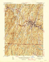
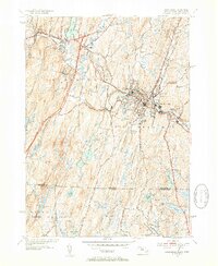
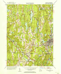 1953 Webster1955 Print · USGSThe Massachusetts and Connecticut borderlands thrive during the early fifties, anchored by the industrial hub of Webster. Researchers can trace the rail lines of the New York New Haven and Hartford RR or locate Nichols College, Fabyan, and South Charlton.3 unique versions available
 - 1954 Map of East Brookfield, 1955 Print
 1954 East Brookfield1955 Print · USGSMid-century Worcester County comes alive in this survey of the river valleys and rail corridors west of Spencer. Local historians can trace the paths of the New York Central Railroad past Quaboag Pond and locate landmarks like Union Chapel or the Podunk Cem.3 unique versions available
 - 1956 Map of Boston, 1967 Print
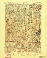
 1956 Boston1967 Print · USGSThe Massachusetts coastline and industrial interior are seen here during the mid-century peak of suburban and highway expansion. Researchers can trace historic harbor defenses like Fort Revere, local landmarks such as Faneuil Hall, and the vast Parker River National Wildlife Refuge.6 unique versions available
 - 1956 Map of Albany, 1968 Print
 1956 Albany1968 Print · USGSThe industrial heart of the Northeast is revealed in the mid-1950s, from the Hudson Valley to the Connecticut River. Researchers can trace the legacy of the Quabbin Reservoir, locate Westover Air Force Base, or follow the Rutland RR through the Green Mountains.2 unique versions available
 - 1957 Map of Albany
 1957 Albany1957 Print · USGSThe Tri-State region and Connecticut River Valley are captured here during a period of significant postwar growth and infrastructure expansion. Genealogists and historians can trace the rail-and-river economy through landmarks like the Boston and Maine railroad, Quabbin Reservoir, and Westover Air Force Base.
 - 1958 Map of Boston
 1958 Boston1958 Print · USGSEastern Massachusetts and southern New Hampshire are shown at the height of the industrial era, before the full expansion of the interstate system. Trace coastal defenses at Fort Warren, historic rail lines like the Boston and Maine, and the development of the Mass. 128 corridor.2 unique versions available
 - 1959 Map of Albany
 1959 Albany1959 Print · USGSThe Hudson and Connecticut River valleys are captured here during the late fifties, showing the region's dense rail networks and massive water projects. Researchers can trace the New York State Thruway or locate local landmarks like Mt Greylock and the Quabbin Reservoir.
 - 1961 Map of Boston
 1961 Boston1961 Print · USGSThe Massachusetts coastline and its industrial interior are detailed here in the mid-twentieth century, from the Monadnock highlands to Cape Cod. Researchers can trace the rail routes of the Boston and Maine or locate landmarks like Fort Devens and the Wachusett Reservoir.2 unique versions available
Showing maps 1-25 of 41
Top cities near Charlton
- Worcester historical maps
- Shrewsbury historical maps
- Webster historical maps
- Southbridge historical maps
- Holden historical maps
- Auburn historical maps
See more
Top neighborhoods of Charlton
- Northside historical maps
- South Charlton historical maps
- Charlton City historical maps
- Charlton Depot historical maps
- Mystic Grove historical maps
- Morseville historical maps
See more
Frequently asked questions
- What are the different types of historical maps available for Charlton?
- What is the oldest map of Charlton?
- Where can I purchase historical maps of Charlton for my home or office?
- Where can I download high-res historical maps of Charlton?
- Are there historical topographic maps available for Charlton?
- Is there historical aerial imagery available for Charlton?
- Where are historical maps of Charlton sourced from?