1930s Maps of Leicester, Massachusetts
Explore 6 historic maps of Leicester from the 1930s. These maps offer a rare glimpse into what life looked like during the 1930s — showing old roads, neighborhoods, homes, and landmarks that have changed or disappeared over time.
Whether you're researching your family's past, planning a metal detecting trip, or studying how Leicester's landscape evolved across the 1930s, these high-resolution maps are a powerful tool for exploring the history of this region.
- Focus on a specific era: All maps on this page are from the 1930s, giving you a focused view of this time period.
- See what’s changed: Compare century-old streets, trails, and buildings to today's modern landscape using overlays and satellite layers.
- Research with precision: Use these maps for genealogy, historical research, land use analysis, or educational projects.
- View, download, or print: Maps are fully viewable online in high resolution, and can be downloaded or printed for your own records.
Start exploring Leicester's history through authentic maps from the 1930s. This is your window into the past.
Leicester, MA maps
(6)- 1934 Map of Worcester
 1934 Worcester1934 Print · USGSMid-depression Worcester and Holden emerge as a dense network of industrial ponds, institutions, and rail lines. Genealogists can trace family connections through the Grove Cem, numerous local schools like Chaffin Sch, and the neighborhoods around Union Sta.
 - 1935 Map of Millbury
 1935 Millbury1935 Print · USGSThe Worcester County countryside in the mid-1930s reveals a dense network of industrial hamlets and rail lines before the modern interstate era. Researchers can trace family roots at St Roche Cem or Bnai Brith Cem and locate vanished schoolhouses like the Hammond Sch.
 - 1937 Map of Leicester
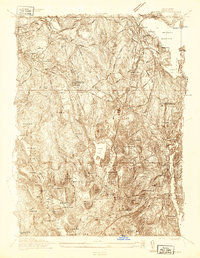
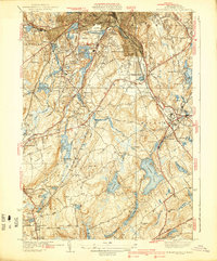
 1937 Leicester1937 Print · USGSWorcester County's industrial villages and highland farms are captured in detail just before the late-century expansion. Genealogists can trace family sites like the Clark Barton Home, Gore Cem, and the specialized Charlton Home Farm.
 - 1937 Map of Paxton
 1937 Paxton1937 Print · USGSWorcester County's upland terrain is captured here in the late 1930s, featuring a landscape of hill-top settlements and industrial hamlets. Genealogists and historians can trace the foundations of Upper Wire Village, locate the Veterans Hospital, or explore the shores of Lake Whittemore.
 - 1939 Map of Worcester South
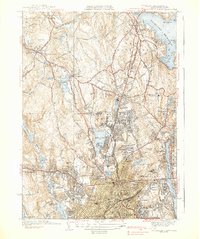
 1939 Worcester South1939 Print · USGSThe Worcester highlands south of the city appear here in the late 1930s, showing a landscape of textile-era mill ponds and expanding suburban rail stops. Researchers can trace family history at St Johns Cemetery or locate old neighborhood landmarks like St Josephs Ch and Hammond Sch.4 unique versions available
 - 1939 Map of Worcester North
 1939 Worcester North1939 Print · USGSThe Worcester hills and reservoirs appear in detail during the late 1930s, documenting a landscape of expanding educational institutions and civic infrastructure. Genealogists and historians can trace Assumption College, Grove Cem, and the old City Farm near Morningdale.5 unique versions available
End of results
Showing maps 1-6 of 6
Top cities near Leicester
- Worcester historical maps
- Shrewsbury historical maps
- Webster historical maps
- Grafton historical maps
- Southbridge historical maps
- Holden historical maps
See more
Top neighborhoods of Leicester
Frequently asked questions
- What are the different types of historical maps available for Leicester?
- What is the oldest map of Leicester?
- Where can I purchase historical maps of Leicester for my home or office?
- Where can I download high-res historical maps of Leicester?
- Are there historical topographic maps available for Leicester?
- Is there historical aerial imagery available for Leicester?
- Where are historical maps of Leicester sourced from?