Old Maps of Franklin County, Maine
Explore 447 old maps of Franklin County, spanning from 1894 to today. These high-resolution historic maps reveal how streets, neighborhoods, landmarks, and natural features evolved over time — perfect for genealogy, metal detecting, research, and local history exploration.
What you can do with these maps:
- See how Franklin County changed over time: Compare historical maps to modern-day views to trace roads, homesites, rail lines & more.
- View detailed metadata: Each map includes creators, publishers, year, scale, and archive source.
- Overlay maps with satellite & LiDAR: Visualize the past alongside modern tools to explore terrain & human change.
- Trusted historical sources: Maps sourced from the USGS, Library of Congress, and other archives.
- Access maps your way: View online, download high-res files, or order prints for personal or research use.
Start exploring old maps of Franklin County to uncover forgotten places, hidden landmarks, and the deep history beneath your feet.
Franklin County, ME maps
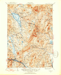
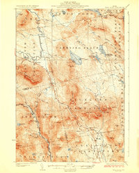
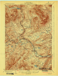
(447)- 1894 Map of Norridgewock
 1894 Norridgewock1894 Print · USGSSomerset and Kennebec counties are shown at the height of the Victorian era, characterized by an intricate network of glacial lakes and river ferries. Genealogists can trace early homesteads and transport points like Davis Ferry, Belgrade Mills, and South Norridgewock.
 - 1898 Map of Norridgewock
 1898 Norridgewock1898 Print · USGSSomerset and Kennebec Counties are shown here during the late Victorian era as the river-and-rail economy thrived. Genealogists can trace family holdings and old crossings like Davis Ferry, Belgrade Mills, and the historic village of Norridgewock.5 unique versions available
 - 1910 Map of Livermore, 1959 Print
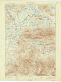
 1910 Livermore1959 Print · USGSMaine's river valleys and lake districts are captured here in the early twentieth century, showing a network of rail-reliant mill towns and rural crossroads. Genealogists can locate family landmarks like Howes Corner and Brettuns Mills, or trace local schools like Saunders School.
 - 1912 Map of Livermore
 1912 Livermore1912 Print · USGSMaine's lake district comes to life in this pre-war survey of the Androscoggin River valley. Genealogists and historians can trace old homesteads and landmarks like Brettuns Mills Livermore P O, Strickland Ferry, and Monmouth Academy.5 unique versions available
 - 1924 Map of Farmington
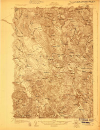
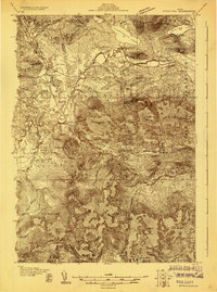
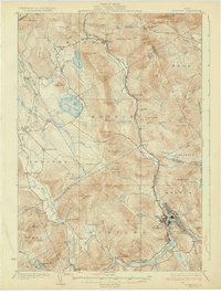
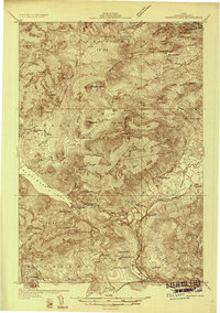
 1924 Farmington1924 Print · USGSFranklin County in the early 1920s is a landscape of river-powered mills and intersecting rail lines, including the Sandy River and Rangeley Lakes RR. Genealogists can locate dozens of country schools and rural settlements like Allens Mills and Knowltons Corner.6 unique versions available
 - 1926 Map of Dixfield, 1953 Print
 1926 Dixfield1953 Print · USGSWestern Maine's river valleys and highlands are captured here in the mid-twenties, showcasing the region's rail and timber economy. Genealogists can trace family schoolhouses like Maple Grove Sch or locate old mill sites such as Hildreths Mill near Lake Webb.2 unique versions available
 - 1927 Map of Rumford
 1927 Rumford1927 Print · USGSOxford County at the end of the twenties shows a landscape of river-valley industry and upland homesteads. Genealogists can trace family school districts like Red Hill Sch and North Rumford Sch or find the Stockbridge Cem near the Garland settlement.3 unique versions available
 - 1928 Map of Chain Lakes
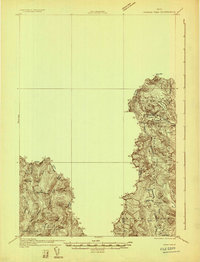
 1928 Chain Lakes1928 Print · USGSThe Maine North Woods and the Canadian border come alive in the late 1920s, showing a landscape defined by timber camps and mountain peaks. Genealogists and historians can trace old forest outposts like Moosehill Camp and Ben Dewitt Camp or the location of Round Mtn PO.
 - 1928 Map of Skinner
 1928 Skinner1928 Print · USGSThe northern Maine woods meet the Canadian border in the late 1920s, dominated by the Canadian Pacific Railway and the Moose River headwaters. Trace the rail-side outposts of Skinner and Summit Camps or the remote waters of Beattie Pond.4 unique versions available
 - 1928 Map of Spencer
 1928 Spencer1928 Print · USGSNorthern Maine's remote logging and sporting country is captured here during the late 1920s. You can trace early wilderness outposts like Gerard (PO) Spencer Lake Camps and Kibby Kamp near Spencer Lake.2 unique versions available
 - 1928 Map of Dead River
 1928 Dead River1928 Print · USGSThe Somerset County wilderness in the mid-twenties is captured here as a landscape of isolated plantations and mountain trails. Genealogists and historians can trace the remote Dead River School and family sites like Joe Farm or the East Carry (Carry Pond P O).6 unique versions available
 - 1928 Map of Stratton
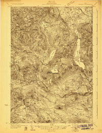
 1928 Stratton1928 Print · USGSThe village of Flagstaff and the Dead River valley appear here in the late 1920s, just decades before the landscape was transformed by damming. You can trace the original valley settlements and landmarks like Morgan Farm, Cathedral Pines, and Morgan Camp.3 unique versions available
 - 1929 Map of Phillips
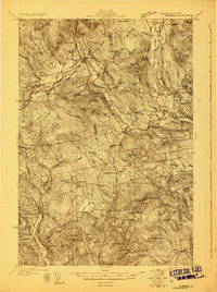
 1929 Phillips1929 Print · USGSFranklin County in the late 1920s is captured here as a network of mountain hamlets and valley mills centered on the Phillips hub. Genealogists and historians can trace defunct schoolhouses like Butterfield Sch and old rail stops at Perham Junction or Madrid Junction.3 unique versions available
 - 1929 Map of Dixfield
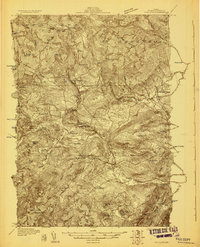
 1929 Dixfield1929 Print · USGSFranklin and Oxford Counties are captured here in the late twenties, showing the transition from mountain peaks to river valley commerce. Genealogists and historians can trace district schools and old farmstead locations from Weld Corner Sch. down to the Maine Central rail lines at Dixfield.5 unique versions available
 - 1930 Map of Rumford
 1930 Rumford1930 Print · USGSRumford and the Androscoggin River valley are shown here just before the Great Depression, highlighting a bustling landscape of rail and industry. Genealogists and historians can trace local families through many district schools like Woodrow Sch and landmarks like Stockbridge Cem or Rumford Falls.5 unique versions available
 - 1930 Map of Kingfield
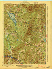
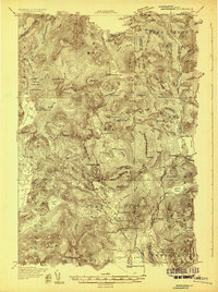
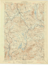
 1930 Kingfield1930 Print · USGSThe Kingfield region and the western Maine highlands are captured here in the early 1930s. Genealogists can locate family homesteads near numerous district schools like Guild Sch and Hardy Sch, or trace the old roads through New Vineyard and Strong.4 unique versions available
 - 1931 Map of Cupsuptic
 1931 Cupsuptic1931 Print · USGSOxford County's rugged northern interior comes to life in this early 1930s survey of the Maine woods. Trace the network of remote outposts and waterways that defined the region, from the Parmachenee Club and Riverside Camp to the waters of Cupsuptic Lake.5 unique versions available
 - 1931 Map of Dead River
 1931 Dead River1931 Print · USGSSomerset and Franklin counties in the mid-1920s show a landscape of remote plantations and traditional woodsman outposts. Genealogists and historians can trace localized landmarks like the Dead River School, the East Carry (Carry Pond PO) Pond, and Joe Farm.
 - 1931 Map of Skinner
 1931 Skinner1931 Print · USGSThe Maine-Quebec borderlands in the late 1920s reveal a landscape of remote rail outposts and logging woods. Trace the path of the Canadian Pacific through Lowelltown, find Hogans Camp, and explore the headwaters of the Moose River.3 unique versions available
 - 1932 Map of Phillips
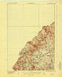
 1932 Phillips1932 Print · USGSFranklin County's mountain-and-valley landscape is captured here in the late twenties, centered on the Sandy River rail corridor. Trace the path of the Rangeley Lakes and Berlin Mills RR past old schoolhouses like Cushman Sch and Avon Valley Sch.4 unique versions available
 - 1932 Map of Stratton
 1932 Stratton1932 Print · USGSThe northern Maine woods in the late twenties and early thirties are captured here during a time of river-driven logging and remote plantation life. Local historians can trace the foundations of Eustis, the original layout of Flagstaff Pond, and rural schoolhouses like Browns Sch.3 unique versions available
 - 1932 Map of Kennebago Lake
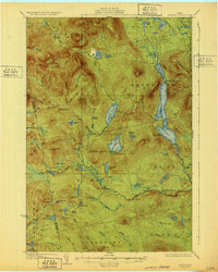
 1932 Kennebago Lake1932 Print · USGSThe Franklin County backcountry in the early thirties is a landscape of isolated timber camps and mountain lakes. Researchers can locate remote industrial sites like Langtown Mill, rural schoolhouses such as Dallas Sch, and the rail-linked Dead River Sta.4 unique versions available
 - 1932 Map of Spencer
 1932 Spencer1932 Print · USGSSomerset County’s wilderness is detailed here in the late twenties, showing a landscape defined by logging camps and remote sporting outposts. Researchers can trace the footprint of the Augusta Lumber Co Camp or locate the Spencer Lake Camps Gerard P O and Kibby Kamp.4 unique versions available
 - 1932 Map of Arnold Pond
 1932 Arnold Pond1932 Print · USGSThe Maine-Quebec borderlands come into focus in the early 1930s, showing a remote landscape of mountain ponds and international crossings. Trace the old route of State Highway No 143 past the U S Customs station near Arnold Pond and Crosby Pond.3 unique versions available
 - 1932 Map of Kingfield
 1932 Kingfield1932 Print · USGSThe western Maine mountains in the early thirties are defined here by narrow-gauge rail lines and a network of river-valley settlements. Genealogists can locate numerous rural schools and family landmarks like Soule Mill, Starbird Sch, and Dyer Hill.3 unique versions available
Showing maps 1-25 of 447
Top cities of Franklin County
- Farmington historical maps
- Jay historical maps
- Wilton historical maps
- New Sharon historical maps
- Chesterville historical maps
- Rangeley historical maps
See more
Frequently asked questions
- What are the different types of historical maps available for Franklin County?
- What is the oldest map of Franklin County?
- Where can I purchase historical maps of Franklin County for my home or office?
- Where can I download high-res historical maps of Franklin County?
- Are there historical topographic maps available for Franklin County?
- Is there historical aerial imagery available for Franklin County?
- Where are historical maps of Franklin County sourced from?