1940s Maps of Allegan County, Michigan
Explore 7 historic maps of Allegan County from the 1940s. These maps offer a rare glimpse into what life looked like during the 1940s — showing old roads, neighborhoods, homes, and landmarks that have changed or disappeared over time.
Whether you're researching your family's past, planning a metal detecting trip, or studying how Allegan County's landscape evolved across the 1940s, these high-resolution maps are a powerful tool for exploring the history of this region.
- Focus on a specific era: All maps on this page are from the 1940s, giving you a focused view of this time period.
- See what’s changed: Compare century-old streets, trails, and buildings to today's modern landscape using overlays and satellite layers.
- Research with precision: Use these maps for genealogy, historical research, land use analysis, or educational projects.
- View, download, or print: Maps are fully viewable online in high resolution, and can be downloaded or printed for your own records.
Start exploring Allegan County's history through authentic maps from the 1940s. This is your window into the past.
Allegan County, MI maps
(7)- 1943 Map of Kalamazoo
 1943 Kalamazoo1943 Print · USGSMid-century Kalamazoo and its northern satellite towns are shown here during a period of industrial and rail prominence. Genealogists can locate dozens of rural landmarks, from Nazareth Academy to local schoolhouses like Grand Prairie Sch and Star Sch.
 - 1943 Map of South Haven
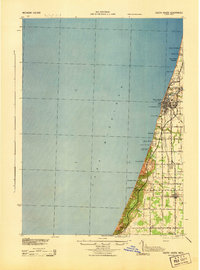 1943 South Haven1943 Print · USGSThe Lake Michigan shoreline at South Haven was a bustling intersection of rail transport and lakeside tourism during the early 1940s. Genealogists and historians can trace old schoolhouses like Fish Sch, the path of the Pere Marquette railroad, and established retreats at Palisades Park.
 - 1943 Map of Grand Rapids
 1943 Grand Rapids1943 Print · USGSGrand Rapids and its surrounding Kent County townships are captured here in the early 1940s, showing a landscape defined by river industry and rail expansion. Genealogists can trace family roots through dozens of named rural schools like Sodom Sch, the County Farm, and early settlements like Byron Center.
 - 1943 Map of Bangor
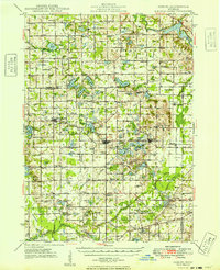
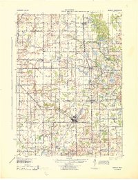 1943 Bangor1943 Print · USGSVan Buren and Allegan counties appear here during the wartime years, when the railway was still the lifeblood of rural Michigan. Genealogists can trace hundreds of farmsteads near Grand Junction, Kibbie, and historic schools like Garden Of Eden Sch.
 - 1946 Map of Gobles, 1948 Print
 1946 Gobles1948 Print · USGSVan Buren County was a landscape of small school districts and lakeside camps just after the war. You can trace the New York Central rail line through Kendall, locate the Wolf Lake Fish Hatchery, and find family roots at the Robinson Cem.
 - 1948 Map of Gobles
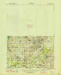
 1948 Gobles1948 Print · USGSVan Buren County was a landscape of small farmsteads and scattered schoolhouses just after the war. Family historians can locate rural landmarks like Robinson Cem, the Wolf Lake Fish Hatchery, and dozens of local schools including Evergreen Sch and Almena Sch.3 unique versions available
 - 1949 Map of Gobles
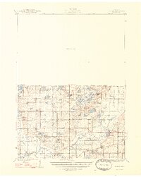
 1949 Gobles1949 Print · USGSVan Buren and Allegan counties appear here at the end of the 1940s, a landscape defined by small-town rail stops and a dense network of country schools. Researchers can trace family sites near Robinson Cem, explore the old New York Central line through Berlamont, or locate the Wolf Lake Fish Hatchery.2 unique versions available
End of results
Showing maps 1-7 of 7
Top cities of Allegan County
- Allegan historical maps
- Plainwell historical maps
- Wayland historical maps
- Otsego historical maps
- Watson historical maps
- Fennville historical maps
See more
Frequently asked questions
- What are the different types of historical maps available for Allegan County?
- What is the oldest map of Allegan County?
- Where can I purchase historical maps of Allegan County for my home or office?
- Where can I download high-res historical maps of Allegan County?
- Are there historical topographic maps available for Allegan County?
- Is there historical aerial imagery available for Allegan County?
- Where are historical maps of Allegan County sourced from?