1930s Maps of Allegan County, Michigan
Explore 4 historic maps of Allegan County from the 1930s. These maps offer a rare glimpse into what life looked like during the 1930s — showing old roads, neighborhoods, homes, and landmarks that have changed or disappeared over time.
Whether you're researching your family's past, planning a metal detecting trip, or studying how Allegan County's landscape evolved across the 1930s, these high-resolution maps are a powerful tool for exploring the history of this region.
- Focus on a specific era: All maps on this page are from the 1930s, giving you a focused view of this time period.
- See what’s changed: Compare century-old streets, trails, and buildings to today's modern landscape using overlays and satellite layers.
- Research with precision: Use these maps for genealogy, historical research, land use analysis, or educational projects.
- View, download, or print: Maps are fully viewable online in high resolution, and can be downloaded or printed for your own records.
Start exploring Allegan County's history through authentic maps from the 1930s. This is your window into the past.
Allegan County, MI maps
(4)- 1930 Map of South Haven
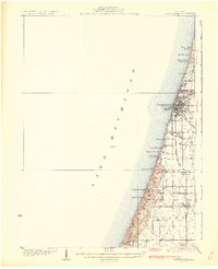 1930 South Haven1930 Print · USGSSouthwest Michigan's lakeshore comes alive in this early Depression-era survey, showing the bustling port of South Haven and its surrounding resort beaches. Genealogists and local historians can trace rural school districts like Fish Sch and landmarks such as the Emanuel Home and Thunder Mtn.4 unique versions available
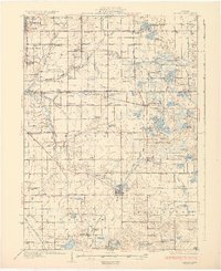
 - 1931 Map of Fennville
 1931 Fennville1931 Print · USGSCoastal Allegan County was a thriving hub of lakefront tourism and rail-based agriculture in the years before the Great Depression. Genealogists and historians can trace family-named schools like Reid Sch and Loomis Sch, or find the Old Saugatuck Light Ho near the river's bend.4 unique versions available
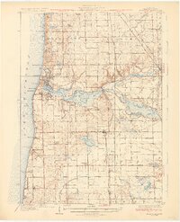
 - 1931 Map of Bangor
 1931 Bangor1931 Print · USGSCoastal resorts and interior farmsteads meet in this early 1930s survey of the Michigan lakefront and the Black River basin. Researchers can trace the PERE MARQUETTE rail line through Grand Junction or locate family sites like Kibbie Chapel and Gardner of Eden Sch.3 unique versions available
 - 1932 Map of Holland
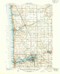 1932 Holland1932 Print · USGSThe Lake Michigan shoreline and the growing city of Holland are captured here in the early 1930s. Trace the lakefront resorts and rural schoolhouses that once dotted the landscape, from Getz Lakewood Farm to the Harderwyk Sch and Noordeloos.2 unique versions available
End of results
Showing maps 1-4 of 4
Top cities of Allegan County
- Allegan historical maps
- Plainwell historical maps
- Wayland historical maps
- Otsego historical maps
- Watson historical maps
- Fennville historical maps
See more
Frequently asked questions
- What are the different types of historical maps available for Allegan County?
- What is the oldest map of Allegan County?
- Where can I purchase historical maps of Allegan County for my home or office?
- Where can I download high-res historical maps of Allegan County?
- Are there historical topographic maps available for Allegan County?
- Is there historical aerial imagery available for Allegan County?
- Where are historical maps of Allegan County sourced from?