1960s Maps of Allegan County, Michigan
Explore 7 historic maps of Allegan County from the 1960s. These maps offer a rare glimpse into what life looked like during the 1960s — showing old roads, neighborhoods, homes, and landmarks that have changed or disappeared over time.
Whether you're researching your family's past, planning a metal detecting trip, or studying how Allegan County's landscape evolved across the 1960s, these high-resolution maps are a powerful tool for exploring the history of this region.
- Focus on a specific era: All maps on this page are from the 1960s, giving you a focused view of this time period.
- See what’s changed: Compare century-old streets, trails, and buildings to today's modern landscape using overlays and satellite layers.
- Research with precision: Use these maps for genealogy, historical research, land use analysis, or educational projects.
- View, download, or print: Maps are fully viewable online in high resolution, and can be downloaded or printed for your own records.
Start exploring Allegan County's history through authentic maps from the 1960s. This is your window into the past.
Allegan County, MI maps
(7)- 1961 Map of Grand Rapids
 1961 Grand Rapids1961 Print · USGSSouthern Michigan at the dawn of the 1960s reveals a region shaped by major river systems and a robust rail network. Trace mid-century industrial growth and land use from Grand Rapids to the Fort Custer Military Reservation and Gun Lake.
 - 1962 Map of Grand Rapids
 1962 Grand Rapids1962 Print · USGSMid-century Southern Michigan is mapped here at a time of massive growth, showing the expanding urban footprints of Grand Rapids and Lansing. Researchers can trace the legacy of the Grand Trunk Western RR, find historic boundaries of the Fort Custer Military Reservation, or locate sporting camps around Gun Lake.2 unique versions available
 - 1962 Map of Racine
 1962 Racine1962 Print · USGSThe Lake Michigan shoreline in the early sixties reveals a fascinating contrast between the dense industrial rail hubs of RACINE and CHICAGO and the forested dunes of Michigan. Local historians can trace military installations like Fort Sheridan or explore the numerous inland retreats around Paw Paw Lake and Sister Lakes.
 - 1967 Map of Otsego, 1969 Print
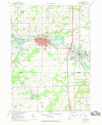 1967 Otsego1969 Print · USGSThe Kalamazoo River corridor in the late sixties shows the industrial and residential growth of Otsego and Plainwell. Trace family roots at Mountain Home Cem or follow the path of the Penn Central railroad and the Otsego-Plainwell Municipal Airport.3 unique versions available
 - 1967 Map of Cutlerville, 1969 Print
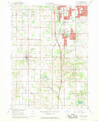 1967 Cutlerville1969 Print · USGSThe southern suburbs of Grand Rapids transition into Kent County farmland during the late sixties. Researchers can trace the development of Cutlerville and Byron Center alongside historic sites like Winchester Cem and Pine Hill.3 unique versions available
 - 1967 Map of Kalamazoo NE, 1969 Print
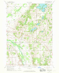 1967 Kalamazoo NE1969 Print · USGSThe rural borderlands of Allegan and Kalamazoo counties are captured here in the late sixties, showing a landscape defined by the Kalamazoo River and the Penn Central line. Local historians can trace family-named sites and vanished stops like Doster, Neeley, and several historic cemeteries including Ives Cem.4 unique versions available
 - 1967 Map of Caledonia, 1969 Print
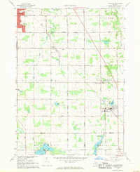 1967 Caledonia1969 Print · USGSThe area around Caledonia and Dutton is documented in the late 1960s as suburban growth begins to meet the rural landscape. Trace the Penn Central rail line and locate community landmarks like Holy Corners, Gaines Sch, and Hanna Lake.3 unique versions available
End of results
Showing maps 1-7 of 7
Top cities of Allegan County
- Allegan historical maps
- Plainwell historical maps
- Wayland historical maps
- Otsego historical maps
- Watson historical maps
- Fennville historical maps
See more
Frequently asked questions
- What are the different types of historical maps available for Allegan County?
- What is the oldest map of Allegan County?
- Where can I purchase historical maps of Allegan County for my home or office?
- Where can I download high-res historical maps of Allegan County?
- Are there historical topographic maps available for Allegan County?
- Is there historical aerial imagery available for Allegan County?
- Where are historical maps of Allegan County sourced from?