1980s Maps of Calhoun County, Michigan
Explore 20 historic maps of Calhoun County from the 1980s. These maps offer a rare glimpse into what life looked like during the 1980s — showing old roads, neighborhoods, homes, and landmarks that have changed or disappeared over time.
Whether you're researching your family's past, planning a metal detecting trip, or studying how Calhoun County's landscape evolved across the 1980s, these high-resolution maps are a powerful tool for exploring the history of this region.
- Focus on a specific era: All maps on this page are from the 1980s, giving you a focused view of this time period.
- See what’s changed: Compare century-old streets, trails, and buildings to today's modern landscape using overlays and satellite layers.
- Research with precision: Use these maps for genealogy, historical research, land use analysis, or educational projects.
- View, download, or print: Maps are fully viewable online in high resolution, and can be downloaded or printed for your own records.
Start exploring Calhoun County's history through authentic maps from the 1980s. This is your window into the past.
Calhoun County, MI maps
(20)- 1980 Map of Duck Lake
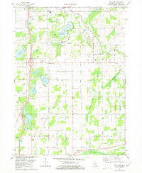
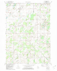
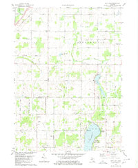 1980 Duck Lake1980 Print · USGSThe Eaton and Calhoun county borderlands in the 1980s show a landscape of quiet lakeside landings and crossroads hamlets. Genealogists and local historians can trace family locations near Partello, Clarence Center, and numerous local burial grounds like Perry Cem.2 unique versions available
 - 1980 Map of Marshall
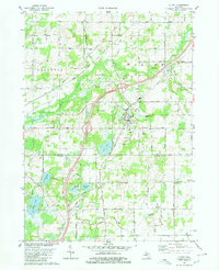
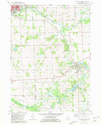
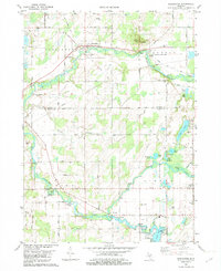
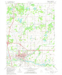 1980 Marshall1980 Print · USGSMarshall and the surrounding Calhoun County townships are shown here as they appeared in 1980, centered on the historic river-and-rail corridor. Genealogists and local historians can locate numerous rural burial grounds like Oakridge Cemetery and Hotchkiss Cem, alongside landmarks such as the Fairground and Walnut Point.
 - 1980 Map of Litchfield
 1980 Litchfield1980 Print · USGSSouth-central Michigan farmland is captured here in the 1970s at the convergence of Hillsdale, Calhoun, and Branch counties. Local researchers can locate family sites near Bentleys Corners, South Litchfield Ch, and Shooks Prairie Cem.
 - 1980 Map of Tekonsha
 1980 Tekonsha1980 Print · USGSTekonsha and the surrounding rural townships are captured in the early eighties as a network of river-side villages and rail-connected farms. Genealogists can trace family names and sites through Riverside Cem, Dayburg Ch, and the outlying settlement of South Butler.
 - 1980 Map of Olivet
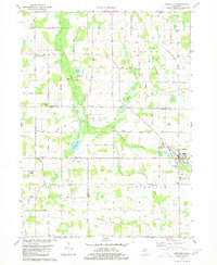
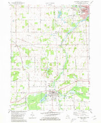
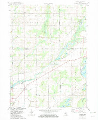
 1980 Olivet1980 Print · USGSOlivet and the Eaton-Calhoun county line are shown in the early 1980s as a landscape of small college-town life and rural industry. Researchers can trace the Grand Trunk Western rail line and locate Bosworth Cem or the Oil Field near Lee Center.
 - 1980 Map of Lyon Lake
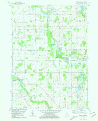
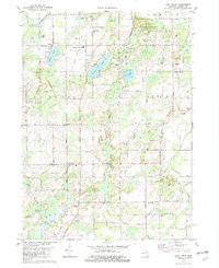
 1980 Lyon Lake1980 Print · USGSCalhoun County's lake country is captured here in the early eighties, showing a landscape of scattered family farms and quiet shorelines. Genealogists can locate family sites near Wrights Corners, West Eckford Cem, or the rural Little Polly Ch.
 - 1980 Map of Northwest Albion
 1980 Northwest Albion1980 Print · USGSCalhoun County in the early eighties shows a transition from the industrial edges of Albion to the quiet township cemeteries and river-fed farms of Marengo. Genealogists can locate family plots at Marengo Village Cem or Krenerick Cem and trace the campus layout of the Starr Commonwealth for Boys.2 unique versions available
 - 1980 Map of Southwest Albion
 1980 Southwest Albion1980 Print · USGSSouth-central Michigan farmland meets the industrial corridors of the late twentieth century in this detailed survey. Genealogists and local historians can trace family locations near Cooks Prairie, identify rural schools like Fletcher School, and locate several historic cemeteries including Fairview Cemetery.
 - 1981 Map of Southeast Albion
 1981 Southeast Albion1981 Print · USGSThe rural landscape between Albion and Concord is captured here in the early 1980s, revealing a network of river-fed townships. Genealogists can locate family sites at Maple Grove Cemetery and West Brick Cem, or trace the winding course of the Kalamazoo River.
 - 1981 Map of Mosherville
 1981 Mosherville1981 Print · USGSSouthern Michigan farm country in the early eighties shows a landscape of river headwaters and small crossroads settlements at the junction of three counties. Genealogists can locate several family-named burial grounds like Mount Hope Cem and Buck Cem, or trace the old Railroad Grade near Mosherville.
 - 1981 Map of Springport
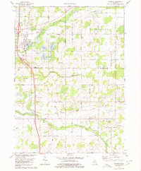
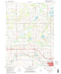
 1981 Springport1981 Print · USGSMid-Michigan's landscape in the early eighties shows a transition from the industrial activity of Eaton Rapids to the quiet rural corners of Springport. Genealogists and historians can trace family sites at Rose Hill Cem or follow the Conrail tracks through Charlesworth.
 - 1981 Map of Northeast Albion
 1981 Northeast Albion1981 Print · USGSThe rural borderlands of Jackson and Calhoun counties come alive in this early 1980s record of Michigan's farming and small-town heartland. Genealogists and local historians can trace the foundations of Springport and Devereaux while locating family plots at Quakertown Cem or Wright Cem.2 unique versions available
 - 1982 Map of Ellis Corners
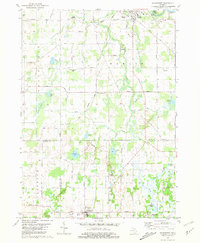
 1982 Ellis Corners1982 Print · USGSCentral Calhoun County in the early eighties shows a landscape of glacial lakes and quiet agricultural townships. Genealogists can trace family names through the Houston Cem or locate community hubs like Ellis Corners and Fredonia Holiness Ch.
 - 1982 Map of Burlington
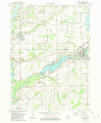
 1982 Burlington1982 Print · USGSSouthern Michigan's river valleys and glacial lakes are captured in detail during the early 1980s as the rail and road network matured. Genealogists and local historians can trace family plots at Township Cem or locate old crossings at Hodunk and Burlington.
 - 1982 Map of Leonidas
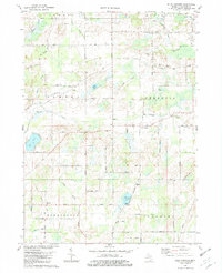
 1982 Leonidas1982 Print · USGSSouthern Michigan farm country and river bottoms are captured here in the early eighties, centered on the village of Leonidas. Researchers can trace local lineages through Leonidas Cem or explore the site of Kings Mill and the Mission Ch.
 - 1982 Map of East Leroy
 1982 East Leroy1982 Print · USGSThe rural landscape south of Battle Creek is detailed in the early eighties, showing a community defined by its township grids and natural drainage. Genealogists can locate family burial sites at Mather Cem and Walker Cem or trace the path of the Old RR Grade.
 - 1982 Map of Union City
 1982 Union City1982 Print · USGSThe confluence of the St Joseph and Coldwater Rivers defines this Branch County region in the early eighties. Genealogists and local historians can trace family plots at Old Burg Cem and Riverside Cem or locate the old CONRAIL tracks through Sherwood.
 - 1982 Map of Climax
 1982 Climax1982 Print · USGSThe borderlands of Kalamazoo and Calhoun Counties are captured here in the early 1980s, showcasing a landscape of established farmsteads and rural townships. Researchers can locate family heritage sites like West Leroy Cemetery, Northside Cemetery, and the Wakeshma Church.
 - 1982 Map of Kalamazoo, 1983 Print
 1982 Kalamazoo1983 Print · USGSThe Kalamazoo River valley in the early eighties shows a landscape of growing suburban centers and heavy rail infrastructure. Genealogists and researchers can trace the limits of Kalamazoo and Battle Creek or locate landmarks like Fort Custer National Cemetery and Gull Lake.
 - 1983 Map of Jackson, 1984 Print
 1983 Jackson1984 Print · USGSJackson and the surrounding lake country are shown in the early eighties as a hub of rail transit and outdoor recreation. Local historians can trace institutional footprints like the State Prison Farm or explore the landscape of Minards Mill and Olivet College.
End of results
Showing maps 1-20 of 20
Top cities of Calhoun County
- Battle Creek historical maps
- Albion historical maps
- Marshall historical maps
- Springfield historical maps
Frequently asked questions
- What are the different types of historical maps available for Calhoun County?
- What is the oldest map of Calhoun County?
- Where can I purchase historical maps of Calhoun County for my home or office?
- Where can I download high-res historical maps of Calhoun County?
- Are there historical topographic maps available for Calhoun County?
- Is there historical aerial imagery available for Calhoun County?
- Where are historical maps of Calhoun County sourced from?