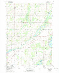
1982 Map of Leonidas
USGS Topo · Published 1982About this map
Nottawa Creek meanders through the heart of this landscape, anchoring a network of small settlements and rural homesteads in the early 1980s. The village of Leonidas serves as a primary hub, situated near the confluence of local waterways and historical road networks like King Road and Tutewiter Road. To the north, the Fulton State Game Area preserves a significant portion of the terrain, while the community of Fulton sits at a crossroads further west. The map documents a landscape defined by its water resources, from the larger St Joseph R to numerous smaller bodies such as Harvey Lake, Blossom Lake, and Marl Lake. Genealogists will find value in the precise locations of the Leonidas Cem and Blossom Cem, as well as the Mission Ch near the northeastern edge of the survey.
Find a feature on this map
45 named features on this map. Tap any name to fly to it.
Don’t see what you’re looking for? This feature index may not catch every label — zoom into the map to look around manually.
Map Details
Editions of this 1982 Leonidas Map
This is the sole edition of this map. No revisions or reprints were ever made.
Other maps of this area

1918 · Union City
USGS Topo · 1:62,500

1918 · Leonidas
USGS Topo · 1:62,500

1944 · Leonidas
USGS Topo · 1:62,500

1947 · Union City
USGS Topo · 1:62,500

1947 · Leonidas
USGS Topo · 1:62,500

1950 · Leonidas
USGS Topo · 1:62,500

1950 · Union City
USGS Topo · 1:62,500

1953 · Fort Wayne
USGS Topo · 1:250,000

1956 · Fort Wayne
USGS Topo · 1:250,000

1958 · Grand Rapids
USGS Topo · 1:250,000