
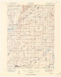
1950 Map of Leonidas
USGS Topo · Published 1950About this map
Leonidas and the St Joseph River corridor define this 1950 portrait of southern Michigan, where the boundaries of Kalamazoo, St. Joseph, Branch, and Calhoun counties meet. This agricultural and wetland landscape is heavily defined by the winding course of the Portage River and numerous glacial lakes, including Indian Lake and Portage Lake. The region’s rural social structure is visible through its dense network of district schools such as Factoryville Sch and Cooks Mill Sch, many of which served farming families centered around crossroads like Fulton and Scotts.
Find a feature on this map
101 named features on this map. Tap any name to fly to it.
Don’t see what you’re looking for? This feature index may not catch every label — zoom into the map to look around manually.
Map Details
Editions of this 1950 Leonidas Map
2 editions found
Other maps of this area

1914 · Three Rivers
USGS Topo · 1:62,500

1916 · Three Rivers
USGS Topo · 1:62,500

1916 · Kalamazoo
USGS Topo · 1:62,500

1918 · Kalamazoo
USGS Topo · 1:62,500

1918 · Battle Creek
USGS Topo · 1:62,500

1918 · Union City
USGS Topo · 1:62,500

1918 · Galesburg
USGS Topo · 1:62,500

1918 · Leonidas
USGS Topo · 1:62,500

1922 · Schoolcraft
USGS Topo · 1:62,500

1943 · Battle Creek
USGS Topo · 1:62,500