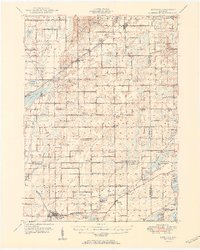
1950 Map of Leonidas
USGS Topo · Published 1950About this map
Leonidas and Mendon anchor this mid-century survey of the rural landscape where Kalamazoo and St. Joseph counties meet. The region is defined by a dense network of one-room schoolhouses and country cemeteries that speak to the established farming communities of the post-war era. Tracing the path of the Portage River and Nottawa Creek, the map details numerous family-named landmarks like McKain Corners and Gardners Corners. Significant water bodies including Indian Lake, Pickerel Lake, and Le Fevre Lake are mapped alongside the tracks of the Grand Trunk and Pennsylvania railroads. This era of Michigan's history is captured before major interstate expansion, showing the original rural roads and small-scale settlements like Scotts and Fulton in their mid-century configuration. The layout of school districts, from Bond Sch to Factoryville Sch, provides a clear view of the local social structure of the time.
Find a feature on this map
71 named features on this map. Tap any name to fly to it.
Don’t see what you’re looking for? This feature index may not catch every label — zoom into the map to look around manually.
Map Details
Editions of this 1950 Leonidas Map
2 editions found

Other maps of this area

1914 · Three Rivers
USGS Topo · 1:62,500

1916 · Three Rivers
USGS Topo · 1:62,500

1916 · Kalamazoo
USGS Topo · 1:62,500

1918 · Kalamazoo
USGS Topo · 1:62,500

1918 · Battle Creek
USGS Topo · 1:62,500

1918 · Union City
USGS Topo · 1:62,500

1918 · Galesburg
USGS Topo · 1:62,500

1918 · Leonidas
USGS Topo · 1:62,500

1922 · Schoolcraft
USGS Topo · 1:62,500

1943 · Battle Creek
USGS Topo · 1:62,500