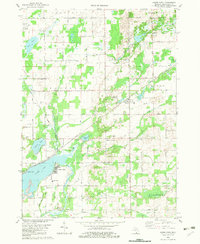
1982 Map of Adams Park
USGS Topo · Published 1982About this map
Scotts and the surrounding township lands of Pavilion and Climax define this landscape in the early 1980s. The region is characterized by a high density of small lakes and agricultural drains, notably Indian Lake Drain and Portage Creek, which weave through a network of rural settlements. Local history is anchored by several rural burying grounds including Cook Cem and Gilson Cem, while the industrial past is visible through Cooks Mill and the Scotts Mill County Park. The Grand Trunk Western railroad corridor provides a clear transit axis through the center of the sheet, connecting the clustered homes at Adams Park with the neighboring McKain Corners. This map documents a stable rural community where one-room schoolhouse sites like Indian Lake Sch and traditional gathering places like Prairie Ch remained central to the local geography.
Find a feature on this map
37 named features on this map. Tap any name to fly to it.
Don’t see what you’re looking for? This feature index may not catch every label — zoom into the map to look around manually.
Map Details
Editions of this 1982 Adams Park Map
This is the sole edition of this map. No revisions or reprints were ever made.
Other maps of this area

1916 · Kalamazoo
USGS Topo · 1:62,500

1918 · Kalamazoo
USGS Topo · 1:62,500

1918 · Galesburg
USGS Topo · 1:62,500

1918 · Leonidas
USGS Topo · 1:62,500

1922 · Schoolcraft
USGS Topo · 1:62,500

1943 · Kalamazoo
USGS Topo · 1:62,500

1943 · Schoolcraft
USGS Topo · 1:62,500

1944 · Leonidas
USGS Topo · 1:62,500

1944 · Galesburg
USGS Topo · 1:62,500

1947 · Augusta
USGS Topo · 1:24,000