1940s Maps of Calhoun County, Michigan
Explore 17 historic maps of Calhoun County from the 1940s. These maps offer a rare glimpse into what life looked like during the 1940s — showing old roads, neighborhoods, homes, and landmarks that have changed or disappeared over time.
Whether you're researching your family's past, planning a metal detecting trip, or studying how Calhoun County's landscape evolved across the 1940s, these high-resolution maps are a powerful tool for exploring the history of this region.
- Focus on a specific era: All maps on this page are from the 1940s, giving you a focused view of this time period.
- See what’s changed: Compare century-old streets, trails, and buildings to today's modern landscape using overlays and satellite layers.
- Research with precision: Use these maps for genealogy, historical research, land use analysis, or educational projects.
- View, download, or print: Maps are fully viewable online in high resolution, and can be downloaded or printed for your own records.
Start exploring Calhoun County's history through authentic maps from the 1940s. This is your window into the past.
Calhoun County, MI maps
(17)- 1943 Map of Battle Creek
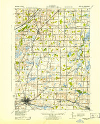
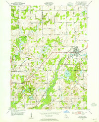
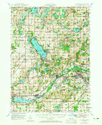
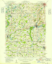
 1943 Battle Creek1943 Print · USGSBattle Creek and the surrounding Calhoun County countryside are shown during the early years of the Second World War. Genealogists and local historians can locate dozens of country schoolhouses like Cobblestone Sch and trace the Grand Trunk Railway through Bellevue and Ceresco.
 - 1943 Map of Marshall
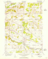
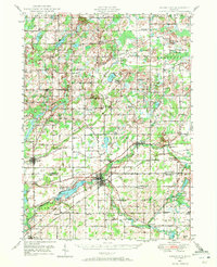
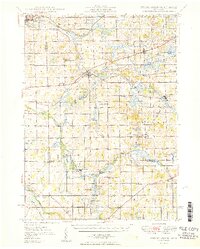
 1943 Marshall1943 Print · USGSCentral Michigan during the early 1940s is defined by its busy rail corridors and small school districts. Genealogists can trace family names at locations like Hockinberry Sch, Olivet, and the Starr Commonwealth Sch.
 - 1944 Map of Leonidas
 1944 Leonidas1944 Print · USGSThe rural borderlands of Kalamazoo and St. Joseph counties are shown here as the region's agricultural and rail networks reached their mid-century peak. Genealogists can trace family locations near dozens of named schools and landmarks like Dutton Cemetery, Kings Mill, and Beard Ch.
 - 1944 Map of Galesburg
 1944 Galesburg1944 Print · USGSDuring the height of World War II, this region was defined by the presence of Fort Custer and the busy Michigan Central rail corridor. Researchers can trace dozens of early rural schoolhouses like Toad Hollow Sch and Grey Sch alongside the sprawling waters of Gull Lake.
 - 1947 Map of Augusta, 1955 Print
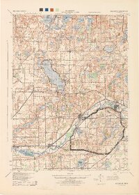
 1947 Augusta1955 Print · USGSThe Kalamazoo and Calhoun county line was a hub of military and medical activity in the late 1940s. Researchers can trace the extensive grounds of the Fort Custer Military Reservation and locate local landmarks like the Veterans Hospital and Martin Sch.
 - 1947 Map of Banfield, 1955 Print
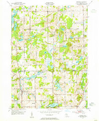
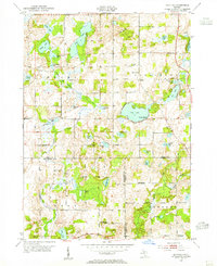 1947 Banfield1955 Print · USGSBarry County was a landscape of quiet glacial lakes and rural schoolhouses just after the war. You can trace the development of lakeside communities like Poplar Beach or locate family roots at Banfield Cem and the King Sch.
 - 1947 Map of Bellevue, 1955 Print
 1947 Bellevue1955 Print · USGSThe town of Bellevue and its surrounding townships are shown here just after the war, centered on the railroad and river. Genealogists can trace family landmarks like Follett Cem, Base Line Ch, and several district schools.
 - 1947 Map of Bedford, 1955 Print
 1947 Bedford1955 Print · USGSThe border of Barry and Calhoun counties in the late 1940s shows a landscape of small lakefront settlements and rural schoolhouses. Genealogists can trace family footprints through sites like Bethel Chapel, Ellis Cem, and the unique Checkered Sch.
 - 1947 Map of Ceresco, 1955 Print
 1947 Ceresco1955 Print · USGSCalhoun County, Michigan, is captured here in the years following World War II, showing a landscape of small river towns and family farms. Researchers can trace dozens of rural schoolhouses and historic burial grounds like Cobblestone Sch and Ceresco Cem along the Kalamazoo River.
 - 1947 Map of Battle Creek, 1955 Print
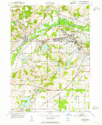
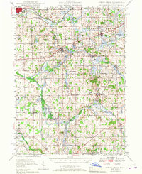
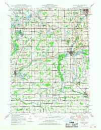
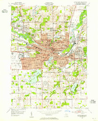 1947 Battle Creek1955 Print · USGSBattle Creek and its surrounding townships thrive in this mid-century survey as a hub of industry, medicine, and education. Genealogists can trace family footprints across dozens of local landmarks like Holy Star Cem, School No 2, and the Sanitarium.
 - 1947 Map of Galesburg, 1965 Print
 1947 Galesburg1965 Print · USGSThe Kalamazoo and Barry County line comes alive in the late 1940s, showing a landscape of lakeside retreats and growing military installations. Genealogists can trace family names at Stony Lake Cem or Bansfield Sch while exploring the pre-interstate corridors of Augusta and Galesburg.
 - 1947 Map of Union City, 1972 Print
 1947 Union City1972 Print · USGSThe St. Joseph River valley in the late 1940s is shown here at its rural peak, shortly after the war. Family historians can trace ancestral sites through dozens of local landmarks like Morgan Cem, Cobblestone Sch, and Burlington Sta.2 unique versions available
 - 1947 Map of Leonidas, 1976 Print
 1947 Leonidas1976 Print · USGSSouthern Michigan rural life is captured here in the late 1940s, showing a landscape defined by small crossroads settlements and the family-run farms between them. Researchers can trace the exact locations of vanished country schools like Hull Sch and rural landmarks such as Kings Mill and Wakeshma Tabernacle.
 - 1948 Map of Spring Arbor, 1967 Print
 1948 Spring Arbor1967 Print · USGSJackson and Hillsdale counties are captured here just after the war, showing a rural landscape still defined by the Kalamazoo River and independent school districts. Genealogists can locate dozens of country schools like Humphrey Sch and old burial grounds such as Bath Mills Cem and Horton Cem.2 unique versions available
 - 1948 Map of Homer, 1968 Print
 1948 Homer1968 Print · USGSSouthern Michigan is captured here just after the war, showing a rural landscape defined by the New York Central rail lines and a dense network of country schoolhouses. Researchers can trace family roots at Shooks Prairie Cem or locate forgotten landmarks like Quaker Mills and Lamm Landing Field.2 unique versions available
 - 1949 Map of Homer
 1949 Homer1949 Print · USGSSouthern Michigan farmland is captured here in the late forties, showing a landscape defined by the upper reaches of the St. Joseph and Kalamazoo Rivers. Genealogists can trace family roots through numerous rural markers like Shooks Prairie Cem, Bentley Corner, and the Quaker Mills Sch.2 unique versions available
 - 1949 Map of Spring Arbor
 1949 Spring Arbor1949 Print · USGSSouthern Michigan's rolling farm country and river valleys are captured here at the close of the 1940s. Genealogists can trace family names at the Bayn Cem or locate the many country schools like Snyder Sch and Humphrey Sch that served this community.2 unique versions available
End of results
Showing maps 1-17 of 17
Top cities of Calhoun County
- Battle Creek historical maps
- Albion historical maps
- Marshall historical maps
- Springfield historical maps
Frequently asked questions
- What are the different types of historical maps available for Calhoun County?
- What is the oldest map of Calhoun County?
- Where can I purchase historical maps of Calhoun County for my home or office?
- Where can I download high-res historical maps of Calhoun County?
- Are there historical topographic maps available for Calhoun County?
- Is there historical aerial imagery available for Calhoun County?
- Where are historical maps of Calhoun County sourced from?