1970s Maps of Charlevoix County, Michigan
Explore 4 historic maps of Charlevoix County from the 1970s. These maps offer a rare glimpse into what life looked like during the 1970s — showing old roads, neighborhoods, homes, and landmarks that have changed or disappeared over time.
Whether you're researching your family's past, planning a metal detecting trip, or studying how Charlevoix County's landscape evolved across the 1970s, these high-resolution maps are a powerful tool for exploring the history of this region.
- Focus on a specific era: All maps on this page are from the 1970s, giving you a focused view of this time period.
- See what’s changed: Compare century-old streets, trails, and buildings to today's modern landscape using overlays and satellite layers.
- Research with precision: Use these maps for genealogy, historical research, land use analysis, or educational projects.
- View, download, or print: Maps are fully viewable online in high resolution, and can be downloaded or printed for your own records.
Start exploring Charlevoix County's history through authentic maps from the 1970s. This is your window into the past.
Charlevoix County, MI maps
(4)- 1975 Map of Boyne City NW, 1976 Print
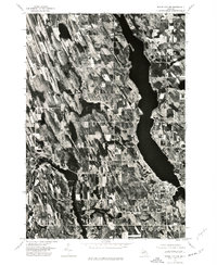 1975 Boyne City NW1976 Print · USGSNorthern Michigan during the mid-seventies comes into focus through this detailed aerial survey of the Charlevoix region. Trace the development of waterfront communities like East Jordan and Ellsworth along the shores of South Arm Lake Charlevoix.
 - 1975 Map of Petoskey SW, 1976 Print
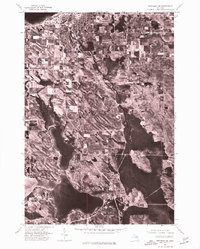 1975 Petoskey SW1976 Print · USGSNorthern Michigan's coastline and interior lakes are captured in high detail during the mid-seventies. Trace the 1975 development of Petoskey along Little Traverse Bay and the shoreline of Walloon Lake.
 - 1975 Map of Boyne City NE, 1976 Print
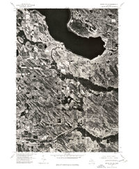 1975 Boyne City NE1976 Print · USGSNorthern Michigan’s shoreline and timbered interior are captured in the mid-seventies just as these lakeside communities were evolving. Researchers can trace the clear urban boundaries of Boyne City and East Jordan against the waters of Lake Charlevoix.
 - 1975 Map of Gaylord SW, 1976 Print
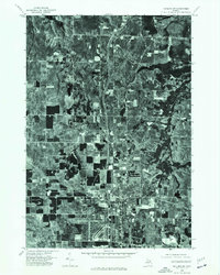 1975 Gaylord SW1976 Print · USGSOtsego County's transition from rural timberland to a regional hub is visible in this mid-seventies aerial survey. Genealogists and local historians can trace the precise development of the Gaylord townsite and the surrounding network of forest roads and clearings.
End of results
Showing maps 1-4 of 4
Top cities of Charlevoix County
Frequently asked questions
- What are the different types of historical maps available for Charlevoix County?
- What is the oldest map of Charlevoix County?
- Where can I purchase historical maps of Charlevoix County for my home or office?
- Where can I download high-res historical maps of Charlevoix County?
- Are there historical topographic maps available for Charlevoix County?
- Is there historical aerial imagery available for Charlevoix County?
- Where are historical maps of Charlevoix County sourced from?