Old Maps of Bessemer Township, Michigan for Academic Research
Study the evolution of Bessemer Township with 68 high-resolution historic maps. Whether you're teaching, researching, or modeling changes in land use, these maps provide essential visual documentation of urban, environmental, and geographic change.
- Analyze long-term change: Track patterns in development, transportation, and natural features.
- Ideal for environmental or urban studies: Support academic projects with primary historical map data.
- Use in the classroom or lab: Educators and researchers rely on these maps to bring historical context to life.
These maps are a powerful tool for teaching, research, and visualizing how Bessemer Township has changed over the decades.
Bessemer Township, MI maps
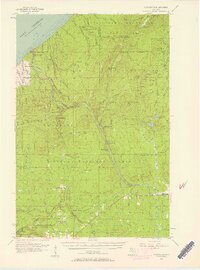
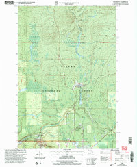
(68)- 1943 Map of Ironwood
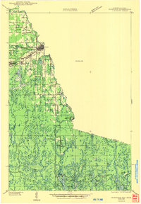 1943 Ironwood1943 Print · USGSThe border country between Wisconsin and Michigan comes alive in this wartime survey of the iron range and timberlands. Researchers can trace early rural life through vanished sites like the Mosinee Lumber Camp, the Chicago and Northwestern Line, and local hubs like Buskirk.2 unique versions available
 - 1953 Map of Ashland, 1964 Print
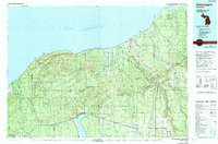
 1953 Ashland1964 Print · USGSNorthern Wisconsin's lakefront and timberlands are seen here in the mid-1950s, showing the intersection of industrial rail lines and vast wilderness. Genealogists and historians can trace the Soo Line through rail towns like Mellen or locate family roots in the Apostle Islands and Bad River Indian Reservation.3 unique versions available
 - 1955 Map of Marenisco, 1957 Print
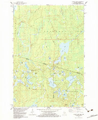
 1955 Marenisco1957 Print · USGSThe Michigan-Wisconsin borderlands and the deep woods of the Upper Peninsula are captured here in the mid-fifties. Genealogists and local historians can trace the rail-and-timber era through Marenisco, the Chicago and North Western line, and fire towers like Copps Lookout Tower.3 unique versions available
 - 1955 Map of Bessemer, 1957 Print
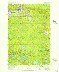
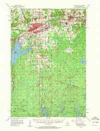
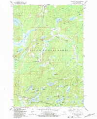
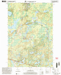
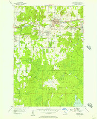 1955 Bessemer1957 Print · USGSIronwood's industrial outskirts and the Gogebic Range mines are at their mid-century peak here in the mid-1950s. Genealogists and researchers can trace the neighborhoods of Anvil, Yale, and Ramsay alongside local landmarks like Washington Sch and the Old Tilden Mine.2 unique versions available
 - 1955 Map of Wakefield, 1957 Print
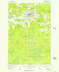 1955 Wakefield1957 Print · USGSWakefield and the iron-rich Gogebic Range are shown here during the mid-1950s as mining operations shaped the landscape. Genealogists and industrial historians can trace the neighborhoods around Sunday Lake, find the Lakeside Cem, and locate mines like the Sunday Lake Mine.2 unique versions available
 - 1955 Map of Wakefield, 1957 Print
 1955 Wakefield1957 Print · USGSThe iron country of the Upper Peninsula is frozen in time during the mid-fifties, showing the industrial core of the Gogebic Range. Genealogists and historians can trace the early layout of Wakefield and its surrounding mining hubs like Ramsay and Verona before the landscape of the Sunday Lake Mine was further altered.3 unique versions available
 - 1955 Map of Wakefield NE, 1957 Print
 1955 Wakefield NE1957 Print · USGSUpper Peninsula timberlands and rail corridors are captured in the mid-1950s within the Ottawa National Forest. Researchers can trace the Chicago and North Western line through forest settlements like Hartley and Dunham or locate the peak of Wolf Mountain.2 unique versions available
 - 1955 Map of Ironwood, 1961 Print
 1955 Ironwood1961 Print · USGSThe Gogebic Range iron district comes to life in this mid-century study of the Michigan-Wisconsin borderlands. Trace the industrial rail networks and mines like Newport Mine alongside the Finnish Ch and vanished local schools.2 unique versions available
 - 1956 Map of North Ironwood, 1957 Print
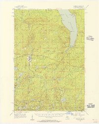
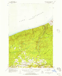 1956 North Ironwood1957 Print · USGSThe Lake Superior shoreline and the waterfall-rich Black River define this mid-century Gogebic County landscape. Researchers can trace rural life through sites like Roosevelt Sch, the Gogebic County Airport, and the Hautala Corner crossroads.3 unique versions available
 - 1956 Map of Thomaston, 1957 Print
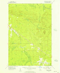
 1956 Thomaston1957 Print · USGSThe Upper Peninsula wilderness in the mid-fifties is captured here, showing the heavy industrial influence of the Chicago and North Western railroad. Researchers can trace the timber-era rail sidings at Tula and Manley Siding or locate the Underwood Lookout Tower.4 unique versions available
 - 1958 Map of Ashland
 1958 Ashland1958 Print · USGSCoastal Wisconsin and the Michigan borderlands meet here in the late fifties, dominated by the timbered expanses and iron-rich ranges. Genealogists can trace family footprints in settlements like Odanah and Montreal, or locate landmarks such as the Coast Guard Station and Agricultural Experiment Station.
 - 1958 Map of Iron River, 1968 Print
 1958 Iron River1968 Print · USGSThe Upper Peninsula in the late fifties is captured here as a landscape of timber, iron, and rail. Genealogists and historians can trace rail stops like Mass Station or explore the coastlines of Lake Gogebic and Keweenaw Bay.3 unique versions available
 - 1960 Map of Iron River
 1960 Iron River1960 Print · USGSThe Upper Peninsula’s western reaches are shown in the late fifties, featuring the industrial infrastructure of the Copper Country and the vast Ottawa National Forest. Researchers can trace the rail lines of the Milwaukee Road through settlements like Bruce Crossing and the White Pine Mine.
 - 1961 Map of Iron River
 1961 Iron River1961 Print · USGSThe Upper Peninsula and northern Wisconsin are shown here in the early 1960s, a landscape defined by the iron range and vast timberlands. Researchers can trace the legacy of mining and rail transport through Caspian, the Lac Du Flambeau Indian Reservation, and the Milwaukee Road.
 - 1967 Map of Iron River, 1968 Print
 1967 Iron River1968 Print · USGSThe Upper Peninsula and northern Wisconsin borderlands are shown here in the late sixties, a landscape of deep woods and iron-country rail lines. Genealogists and historians can trace the lakeside settlements of L'Anse and Ontonagon or follow the Soo Line through towns like Michigamme and Nestoria.
 - 1979 Map of Ontonagon, 1991 Print
 1979 Ontonagon1991 Print · USGSThe Western Upper Peninsula coastline and copper country are captured here during the late twentieth century. Genealogists and historians can trace the rail-and-river network connecting settlements like White Pine, Lake Mine, and Bruce Crossing.
 - 1980 Map of Ironwood
 1980 Ironwood1980 Print · USGSThe Michigan-Wisconsin borderlands appear in the late twentieth century as a landscape defined by iron mining and deep forests. Researchers can trace the rail-and-river economy through the Soo Line and Chicago and North Western tracks connecting Mellen, Glidden, and Hurley.
 - 1981 Map of Thomaston
 1981 Thomaston1981 Print · USGSGogebic County in the early eighties shows a landscape of timber management and mining infrastructure. You can trace the path of the Soo Line through settlements like Thomaston and Connorville or locate natural landmarks such as Gabbro Falls and Minnewawa Falls.
 - 1982 Map of Harris Lake, 1983 Print
 1982 Harris Lake1983 Print · USGSThe Northwoods border country between Wisconsin and Michigan is shown here in the early eighties, centered on a dense network of glacial lakes. Local researchers can trace old roads like Forest 15 and locate landmarks such as the Landing Strip and Harris Lake.
 - 1982 Map of Chaney Lake, 1983 Print
 1982 Chaney Lake1983 Print · USGSThe Michigan-Wisconsin borderlands appear here in the early 1980s, centered on the complex lake systems of Gogebic County and Vilas County. Researchers can trace the Old Railroad Grade through the hamlet of Chaney or locate landmarks like the Trostel Lookout Tower.
 - 1982 Map of Stateline Lake, 1983 Print
 1982 Stateline Lake1983 Print · USGSThe Michigan-Wisconsin borderlands in the early eighties are documented here, showing a wilderness of glacial lakes and timber land. Genealogists and researchers can locate Wellington and Camp Ojibway or trace the Chicago and North Western line through the Ottawa National Forest.
 - 1989 Map of Ashland
 1989 Ashland1989 Print · USGSCoastal Wisconsin and Michigan at the end of the 1980s show a landscape of deep-water bays, island preserves, and industrial timber towns. Researchers can trace the rail lines of the Soo Line and identify landmarks from Big Bay State Park to the Bad River Indian Reservation.
 - 1990 Map of Wakefield
 1990 Wakefield1990 Print · USGSThe Michigan-Wisconsin borderlands are captured here in the late twentieth century, showing the transition from an industrial rail-and-timber hub to a recreation-focused landscape. Trace the Chicago & North Western RR through Marenisco or locate landmarks like Agate Falls and Wakefield.
 - 1999 Map of Stateline Lake, 2004 Print
 1999 Stateline Lake2004 Print · USGSThe Michigan-Wisconsin borderlands appear here in the late nineties as a dense network of forest roads and glacial lakes. Local researchers can trace the footprint of Camp Ojibway and early lakefront developments like Bobcat Lake Beach.
 - 1999 Map of Thomaston, 2004 Print
 1999 Thomaston2004 Print · USGSThe Ottawa National Forest in the late nineties is revealed here through its timber and recreational landscapes. Trace local history at Thomaston, Connorville, and the Manley Siding rail point, or explore landmarks like Gabbro Falls and the Indianhead Mountain Ski Area.
Showing maps 1-25 of 68
Top cities near Bessemer Township
- Ironwood historical maps
- Wakefield historical maps
- Bessemer historical maps
- Mercer historical maps
- Boulder Junction historical maps
- Presque Isle historical maps
See more
Top neighborhoods of Bessemer Township
Frequently asked questions
- What are the different types of historical maps available for Bessemer Township?
- What is the oldest map of Bessemer Township?
- Where can I purchase historical maps of Bessemer Township for my home or office?
- Where can I download high-res historical maps of Bessemer Township?
- Are there historical topographic maps available for Bessemer Township?
- Is there historical aerial imagery available for Bessemer Township?
- Where are historical maps of Bessemer Township sourced from?