1980s Maps of Ironwood Township, Michigan
Explore 7 historic maps of Ironwood Township from the 1980s. These maps offer a rare glimpse into what life looked like during the 1980s — showing old roads, neighborhoods, homes, and landmarks that have changed or disappeared over time.
Whether you're researching your family's past, planning a metal detecting trip, or studying how Ironwood Township's landscape evolved across the 1980s, these high-resolution maps are a powerful tool for exploring the history of this region.
- Focus on a specific era: All maps on this page are from the 1980s, giving you a focused view of this time period.
- See what’s changed: Compare century-old streets, trails, and buildings to today's modern landscape using overlays and satellite layers.
- Research with precision: Use these maps for genealogy, historical research, land use analysis, or educational projects.
- View, download, or print: Maps are fully viewable online in high resolution, and can be downloaded or printed for your own records.
Start exploring Ironwood Township's history through authentic maps from the 1980s. This is your window into the past.
Ironwood Township, MI maps
(7)- 1980 Map of Ironwood
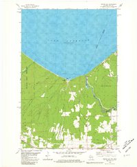
 1980 Ironwood1980 Print · USGSThe Michigan-Wisconsin borderlands appear in the late twentieth century as a landscape defined by iron mining and deep forests. Researchers can trace the rail-and-river economy through the Soo Line and Chicago and North Western tracks connecting Mellen, Glidden, and Hurley.
 - 1980 Map of Oronto Bay, 1981 Print
 1980 Oronto Bay1981 Print · USGSThe Wisconsin-Michigan borderlands come alive in this early 1980s survey of the Montreal River and the shores of Oronto Bay. Researchers can trace family history at Saxon Union Cem or explore the river’s power at Superior Falls and Saxon Falls.
 - 1980 Map of Little Girls Point, 1981 Print
 1980 Little Girls Point1981 Print · USGSThe Michigan-Wisconsin borderlands along the Lake Superior shoreline come into focus during the early eighties. Genealogists and local historians can locate the Little Girls Point burial grounds or trace the winding Montreal River past Saxon Falls Flowage.
 - 1980 Map of Black River Harbor, 1981 Print
 1980 Black River Harbor1981 Print · USGSThe Lake Superior shoreline and the lower Black River come alive in the 1980s as a hub for recreation and forestry. Trace the series of cataracts along the river including Rainbow Falls and Great Conglomerate Falls, or follow the path of the Old RR Grade.
 - 1980 Map of Tiebel Creek, 1981 Print
 1980 Tiebel Creek1981 Print · USGSThe Upper Peninsula wilderness along Lake Superior is captured here during the early eighties, where the Porcupine Mountains meet the coast. Trace the industrial legacy of the Old Railroad Grade or locate remote landmarks like Summit Peak and Beaver Lake.2 unique versions available
 - 1981 Map of Thomaston
 1981 Thomaston1981 Print · USGSGogebic County in the early eighties shows a landscape of timber management and mining infrastructure. You can trace the path of the Soo Line through settlements like Thomaston and Connorville or locate natural landmarks such as Gabbro Falls and Minnewawa Falls.
 - 1989 Map of Ashland
 1989 Ashland1989 Print · USGSCoastal Wisconsin and Michigan at the end of the 1980s show a landscape of deep-water bays, island preserves, and industrial timber towns. Researchers can trace the rail lines of the Soo Line and identify landmarks from Big Bay State Park to the Bad River Indian Reservation.
End of results
Showing maps 1-7 of 7
Top cities near Ironwood Township
- Ironwood historical maps
- Wakefield historical maps
- Bessemer historical maps
- Hurley historical maps
- Montreal historical maps
- Kimball historical maps
See more
Top neighborhoods of Ironwood Township
- Little Girl's Point historical maps
- Junet historical maps
- North Ironwood historical maps
- North Bessemer historical maps
- Auvinen Corner historical maps
- Hautala Corner historical maps
See more
Frequently asked questions
- What are the different types of historical maps available for Ironwood Township?
- What is the oldest map of Ironwood Township?
- Where can I purchase historical maps of Ironwood Township for my home or office?
- Where can I download high-res historical maps of Ironwood Township?
- Are there historical topographic maps available for Ironwood Township?
- Is there historical aerial imagery available for Ironwood Township?
- Where are historical maps of Ironwood Township sourced from?