1960s Maps of Ingham County, Michigan
Explore 5 historic maps of Ingham County from the 1960s. These maps offer a rare glimpse into what life looked like during the 1960s — showing old roads, neighborhoods, homes, and landmarks that have changed or disappeared over time.
Whether you're researching your family's past, planning a metal detecting trip, or studying how Ingham County's landscape evolved across the 1960s, these high-resolution maps are a powerful tool for exploring the history of this region.
- Focus on a specific era: All maps on this page are from the 1960s, giving you a focused view of this time period.
- See what’s changed: Compare century-old streets, trails, and buildings to today's modern landscape using overlays and satellite layers.
- Research with precision: Use these maps for genealogy, historical research, land use analysis, or educational projects.
- View, download, or print: Maps are fully viewable online in high resolution, and can be downloaded or printed for your own records.
Start exploring Ingham County's history through authentic maps from the 1960s. This is your window into the past.
Ingham County, MI maps
(5)- 1961 Map of Grand Rapids
 1961 Grand Rapids1961 Print · USGSSouthern Michigan at the dawn of the 1960s reveals a region shaped by major river systems and a robust rail network. Trace mid-century industrial growth and land use from Grand Rapids to the Fort Custer Military Reservation and Gun Lake.
 - 1962 Map of Grand Rapids
 1962 Grand Rapids1962 Print · USGSMid-century Southern Michigan is mapped here at a time of massive growth, showing the expanding urban footprints of Grand Rapids and Lansing. Researchers can trace the legacy of the Grand Trunk Western RR, find historic boundaries of the Fort Custer Military Reservation, or locate sporting camps around Gun Lake.2 unique versions available
 - 1965 Map of Lansing South, 1967 Print
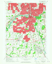 1965 Lansing South1967 Print · USGSGreater Lansing is captured in a period of significant mid-century expansion along the Grand River and Red Cedar River corridors. Genealogists and local historians can trace family plots in Mt Hope Cemetery or locate old neighborhood landmarks like St Mary Sch and the settlement of Millett.3 unique versions available
 - 1965 Map of Lansing North, 1967 Print
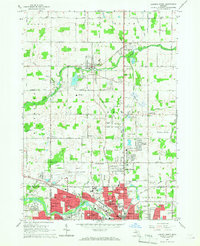 1965 Lansing North1967 Print · USGSThe northern reaches of Lansing and the rural DeWitt area come to life in this mid-sixties survey. Researchers can trace family history at St Joseph Cemetery, locate old schoolhouses like Brown Sch, and follow the New York Central Railroad corridor.3 unique versions available
 - 1965 Map of Aurelius, 1967 Print
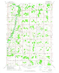 1965 Aurelius1967 Print · USGSIngham County's rural landscape is captured here in the mid-1960s, showing a transition from traditional farmsteads to modern township development. Genealogists can trace family roots through several local landmarks like Skinner Cem, Petrieville, and the North Aurelius Sch.2 unique versions available
End of results
Showing maps 1-5 of 5
Top cities of Ingham County
Frequently asked questions
- What are the different types of historical maps available for Ingham County?
- What is the oldest map of Ingham County?
- Where can I purchase historical maps of Ingham County for my home or office?
- Where can I download high-res historical maps of Ingham County?
- Are there historical topographic maps available for Ingham County?
- Is there historical aerial imagery available for Ingham County?
- Where are historical maps of Ingham County sourced from?