1970s Maps of Easton Township, Michigan
Explore 4 historic maps of Easton Township from the 1970s. These maps offer a rare glimpse into what life looked like during the 1970s — showing old roads, neighborhoods, homes, and landmarks that have changed or disappeared over time.
Whether you're researching your family's past, planning a metal detecting trip, or studying how Easton Township's landscape evolved across the 1970s, these high-resolution maps are a powerful tool for exploring the history of this region.
- Focus on a specific era: All maps on this page are from the 1970s, giving you a focused view of this time period.
- See what’s changed: Compare century-old streets, trails, and buildings to today's modern landscape using overlays and satellite layers.
- Research with precision: Use these maps for genealogy, historical research, land use analysis, or educational projects.
- View, download, or print: Maps are fully viewable online in high resolution, and can be downloaded or printed for your own records.
Start exploring Easton Township's history through authentic maps from the 1970s. This is your window into the past.
Easton Township, MI maps
(4)- 1972 Map of Belding, 1974 Print
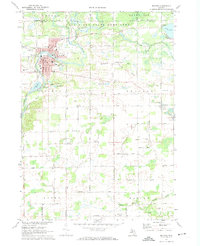 1972 Belding1974 Print · USGSThe Ionia County countryside is captured here in the early seventies, centered on the river-fed industrial core and rural townships. Researchers can trace family history through landmarks like Seeley Church of God, River Ridge Cem, and the old Chesapeake and Ohio rail line.
 - 1972 Map of Shiloh, 1974 Print
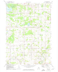 1972 Shiloh1974 Print · USGSIonia and Montcalm counties are shown in the early seventies, centered on rural farming communities and the local school system. Researchers can trace family-named roads and sites like Higbee Cem, Shiloh, and the Old Grade railroad bed.
 - 1978 Map of Ionia, 1979 Print
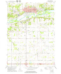 1978 Ionia1979 Print · USGSIonia and its surrounding townships are shown here in the late seventies, centered on the strategic confluence of the Grand River and Prairie Creek. Genealogists and local researchers can trace the locations of the Ionia State Reformatory, the Little White Ch, and several family cemeteries like Tuttle Cem.
 - 1978 Map of Saranac, 1979 Print
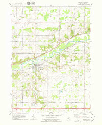 1978 Saranac1979 Print · USGSThe Grand River valley in Ionia County is captured here during the late 1970s, showcasing the village of Saranac and its rural surroundings. Genealogists and local historians can trace the settlement patterns around Potters Corners, Berlin Center, and the White Cem graveyard.
End of results
Showing maps 1-4 of 4
Top cities near Easton Township
- Ionia historical maps
- Greenville historical maps
- Lowell Charter Township historical maps
- Belding historical maps
- Vergennes Township historical maps
- Lowell historical maps
See more
Frequently asked questions
- What are the different types of historical maps available for Easton Township?
- What is the oldest map of Easton Township?
- Where can I purchase historical maps of Easton Township for my home or office?
- Where can I download high-res historical maps of Easton Township?
- Are there historical topographic maps available for Easton Township?
- Is there historical aerial imagery available for Easton Township?
- Where are historical maps of Easton Township sourced from?