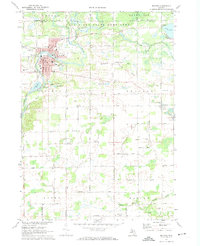
1972 Map of Belding
USGS Topo · Published 1974About this map
The Flat River winds through the heart of the landscape, defining the industrial and civic development of Belding during the early 1970s. The city's structure is detailed through landmarks like City Hall, the Hospital, and several local schools such as Washington Sch and Hall Park Sch. To the north, the Flat River State Game Area preserves a broad stretch of wetlands and forest around Dickerson Creek and Long Lake. This survey illustrates a rural-industrial transition, where the Chesapeake and Ohio railroad corridor connects the urban center to the small outlying village of Orleans. The map is particularly useful for genealogical research, capturing numerous rural landmarks including the Seeley Church of God, the Dildine Ch, and several well-distributed burial sites such as River Ridge Cem and Greenop Cem.
Find a feature on this map
49 named features on this map. Tap any name to fly to it.
Don’t see what you’re looking for? This feature index may not catch every label — zoom into the map to look around manually.
Map Details
Editions of this 1972 Belding Map
This is the sole edition of this map. No revisions or reprints were ever made.
Other maps of this area

1916 · Ionia
USGS Topo · 1:62,500

1918 · Ionia
USGS Topo · 1:62,500

1918 · Lowell
USGS Topo · 1:62,500

1943 · Ionia
USGS Topo · 1:62,500

1943 · Lowell
USGS Topo · 1:62,500

1954 · Midland
USGS Topo · 1:250,000

1958 · Midland
USGS Topo · 1:250,000

1958 · Grand Rapids
USGS Topo · 1:250,000

1959 · Midland
USGS Topo · 1:250,000

1961 · Grand Rapids
USGS Topo · 1:250,000