1940s Maps of Crystal Falls Township, Michigan
Explore 10 historic maps of Crystal Falls Township from the 1940s. These maps offer a rare glimpse into what life looked like during the 1940s — showing old roads, neighborhoods, homes, and landmarks that have changed or disappeared over time.
Whether you're researching your family's past, planning a metal detecting trip, or studying how Crystal Falls Township's landscape evolved across the 1940s, these high-resolution maps are a powerful tool for exploring the history of this region.
- Focus on a specific era: All maps on this page are from the 1940s, giving you a focused view of this time period.
- See what’s changed: Compare century-old streets, trails, and buildings to today's modern landscape using overlays and satellite layers.
- Research with precision: Use these maps for genealogy, historical research, land use analysis, or educational projects.
- View, download, or print: Maps are fully viewable online in high resolution, and can be downloaded or printed for your own records.
Start exploring Crystal Falls Township's history through authentic maps from the 1940s. This is your window into the past.
Crystal Falls Township, MI maps
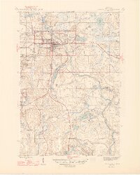
(10)- 1944 Map of Crystal Falls, 1956 Print
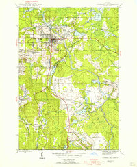 1944 Crystal Falls1956 Print · USGSIron County mining settlements and railroads are captured in this mid-century survey of the Upper Peninsula. Genealogists can trace family connections to industrial sites like Tobin Mine and company housing at Shafer Location or Western Location.
 - 1944 Map of Fortune Lakes, 1958 Print
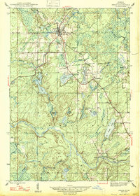
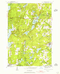 1944 Fortune Lakes1958 Print · USGSIron County, Michigan, was a landscape of remote timber and rail-bound mining settlements during the mid-1940s. Genealogists and historians can trace the residents of Alpha and Pentoga or locate the specialized mining outposts at Dunn Location and New Bridge Location.2 unique versions available
 - 1945 Map of Kelso Junction, 1968 Print
 1945 Kelso Junction1968 Print · USGSIron County's timber and rail landscape is well-defined here during the mid-forties, centered on the Paint River drainage. Genealogists and historians can trace the Milwaukee and Pacific line to Kelso Junction and Mitchell Spur.2 unique versions available
 - 1945 Map of Amasa, 1970 Print
 1945 Amasa1970 Print · USGSIron County’s mining and rail history is frozen in time during the mid-1940s near the Hematite district. Genealogists can trace family footprints at Amasa, locate the Casagranda Race Track, or study industrial sites like the Warner Mine (abandoned).2 unique versions available
 - 1946 Map of Crystal Falls
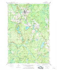
 1946 Crystal Falls1946 Print · USGSMining locations and rail lines dominate the Iron County landscape during the mid-forties. Genealogists and historians can trace the specific neighborhoods of Western Location and Odgers Location or locate the industrial footprints of the Shafer Mine and Tobin Mine.2 unique versions available
 - 1946 Map of Fortune Lakes
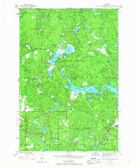
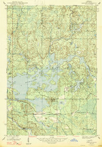
 1946 Fortune Lakes1946 Print · USGSIron County's lake country is captured here just after the war, showing the intersection of industrial mining life and growing public recreation. Researchers can trace old rail lines and worker settlements like New Bristol Location and Dunn Location near Bewabic Park.2 unique versions available
 - 1947 Map of Kiernan
 1947 Kiernan1947 Print · USGSIron County’s timber and water landscapes are captured here shortly after the war, showing the newly formed Michigamme Reservoir. Genealogists and historians can trace the rail corridor of the Chicago Milwaukee St Paul and Pacific and the small settlement at Kiernan.2 unique versions available
 - 1947 Map of Lake Mary
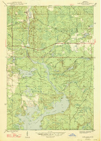 1947 Lake Mary1947 Print · USGSIron County, Michigan, is shown here shortly after the war, where the industrial legacy of the Northwoods meets its sprawling river system. Researchers can trace the Old Railroad Grade past Mansfield or locate School No 2 near the banks of the Michigan River.2 unique versions available
 - 1947 Map of Amasa
 1947 Amasa1947 Print · USGSIron County's mining and timber landscape comes into focus shortly after the war, centered on the settlement of Amasa. Researchers can trace the legacy of local industry at the Warner Mine (abandoned), Porter Mine (abandoned), and the Casagranda Race Track.2 unique versions available
 - 1947 Map of Kelso Junction
 1947 Kelso Junction1947 Print · USGSIron County’s timber and rail landscape is captured here in the late 1940s, centered on the newly shaped waters of the Michigamme Reservoir. Genealogists and rail historians can trace the intersection of the Chicago and North Western and the Milwaukee St Paul and Pacific Railroad near Kelso Junction.2 unique versions available
End of results
Showing maps 1-10 of 10
Top cities near Crystal Falls Township
Top neighborhoods of Crystal Falls Township
- Monongahela Location historical maps
- Odgers Location historical maps
- Shafer Location historical maps
- Tobin Location historical maps
- Balsam historical maps
- Erickson Landing historical maps
See more
Frequently asked questions
- What are the different types of historical maps available for Crystal Falls Township?
- What is the oldest map of Crystal Falls Township?
- Where can I purchase historical maps of Crystal Falls Township for my home or office?
- Where can I download high-res historical maps of Crystal Falls Township?
- Are there historical topographic maps available for Crystal Falls Township?
- Is there historical aerial imagery available for Crystal Falls Township?
- Where are historical maps of Crystal Falls Township sourced from?