1900-1909 Maps of Hartland Township, Michigan
Explore 3 historic maps of Hartland Township from 1900-1909. These maps offer a rare glimpse into what life looked like during the 1900s — showing old roads, neighborhoods, homes, and landmarks that have changed or disappeared over time.
Whether you're researching your family's past, planning a metal detecting trip, or studying how Hartland Township's landscape evolved across the 1900s, these high-resolution maps are a powerful tool for exploring the history of this region.
- Focus on a specific era: All maps on this page are from the 1900s, giving you a focused view of this time period.
- See what’s changed: Compare century-old streets, trails, and buildings to today's modern landscape using overlays and satellite layers.
- Research with precision: Use these maps for genealogy, historical research, land use analysis, or educational projects.
- View, download, or print: Maps are fully viewable online in high resolution, and can be downloaded or printed for your own records.
Start exploring Hartland Township's history through authentic maps from the 1900s. This is your window into the past.
Hartland Township, MI maps
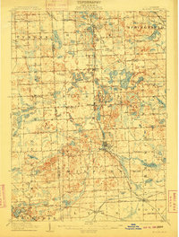
(3)- 1907 Map of Howell, 1959 Print
 1907 Howell1959 Print · USGSLivingston County is mapped here in the early twentieth century as a busy rail and agricultural center. Researchers can trace the legacy of rural education and industry through dozens of local sites like Jubb School, Parker Church, and the State Sanitarium.2 unique versions available
 - 1909 Map of Howell
 1909 Howell1909 Print · USGSLivingston County's landscape at the dawn of the century was defined by the crossing of major rail lines and the historic Grand River Road. Genealogists and local historians can trace the early sites of Oak Grove, Parshallyville, and the State Sanitarium.2 unique versions available
 - 1909 Map of Milford
 1909 Milford1909 Print · USGSIn the decade before the automobile era, this area of Oakland County was a patchwork of lakefront settlements and busy rail junctions. Genealogists can trace family footprints near Spring Mills or rural landmarks like the Remington Church and Kenny School.4 unique versions available
End of results
Showing maps 1-3 of 3
Top cities near Hartland Township
- Novi historical maps
- Commerce Charter Township historical maps
- Northville Charter Township historical maps
- White Lake Charter Township historical maps
- Lyon Charter Township historical maps
- Hamburg Township historical maps
See more
Top neighborhoods of Hartland Township
Frequently asked questions
- What are the different types of historical maps available for Hartland Township?
- What is the oldest map of Hartland Township?
- Where can I purchase historical maps of Hartland Township for my home or office?
- Where can I download high-res historical maps of Hartland Township?
- Are there historical topographic maps available for Hartland Township?
- Is there historical aerial imagery available for Hartland Township?
- Where are historical maps of Hartland Township sourced from?