1960s Maps of Luce County, Michigan
Explore 12 historic maps of Luce County from the 1960s. These maps offer a rare glimpse into what life looked like during the 1960s — showing old roads, neighborhoods, homes, and landmarks that have changed or disappeared over time.
Whether you're researching your family's past, planning a metal detecting trip, or studying how Luce County's landscape evolved across the 1960s, these high-resolution maps are a powerful tool for exploring the history of this region.
- Focus on a specific era: All maps on this page are from the 1960s, giving you a focused view of this time period.
- See what’s changed: Compare century-old streets, trails, and buildings to today's modern landscape using overlays and satellite layers.
- Research with precision: Use these maps for genealogy, historical research, land use analysis, or educational projects.
- View, download, or print: Maps are fully viewable online in high resolution, and can be downloaded or printed for your own records.
Start exploring Luce County's history through authentic maps from the 1960s. This is your window into the past.
Luce County, MI maps
(12)- 1962 Map of Auger Lake, 1974 Print
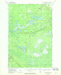
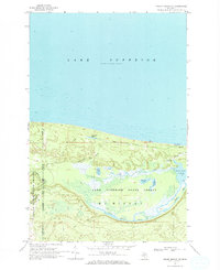
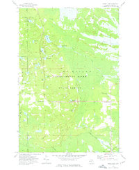 1962 Auger Lake1974 Print · USGSLuce County’s timberlands and remote outposts are captured here in the early 1970s, showcasing a landscape of dense forests and legacy rail grades. Researchers can trace historic industrial footprints at Cleveland Cliffs Lake and old transit hubs like Eightmile Corner and Carson.
 - 1964 Map of Rexton, 1966 Print
 1964 Rexton1966 Print · USGSThe Upper Peninsula’s timber and mining heritage is on display in this mid-century survey of Mackinac County. Researchers can trace the legacy of the Fiborn Quarry and the Soo Line railroad near Rexton and the Caffey Cem.2 unique versions available
 - 1968 Map of Muskallonge Lake East, 1970 Print
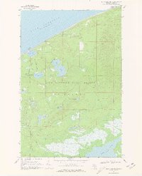
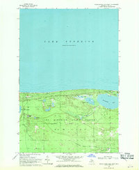
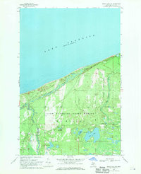
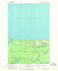 1968 Muskallonge Lake East1970 Print · USGSThe Luce County shoreline on Lake Superior's southern edge was a mix of logging history and emerging recreation in the late sixties. Researchers can trace the Old Railroad Grade near Deer Park or locate backcountry spots like the Reed and Green Bridge Campground.2 unique versions available
 - 1968 Map of Betsy Lake North, 1970 Print
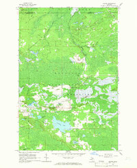
 1968 Betsy Lake North1970 Print · USGSThe Lake Superior shoreline and the deep woods of the Upper Peninsula are captured here in the late sixties. Trace the isolation of Crisp Point and its lighthouse or follow the primitive jeep trails toward Culhane Lake and BETSY LAKE.2 unique versions available
 - 1968 Map of Muskallonge Lake SW, 1970 Print
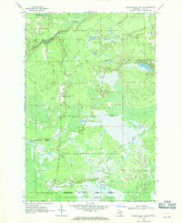
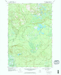
 1968 Muskallonge Lake SW1970 Print · USGSThe Luce County wilderness comes into focus during the late 1960s, showing the intricate headwaters of the legendary Two Hearted River. You can trace the remote network of logging routes and trails like Ohio Camp Road and locate the West Lookout Tower among dozens of named water bodies like Beaver Lake.2 unique versions available
 - 1968 Map of Muskallonge Lake West, 1970 Print
 1968 Muskallonge Lake West1970 Print · USGSThe rugged shoreline of the Upper Peninsula is captured here in the late sixties, showing the intersection of the Great Lakes coast and the deep woods. Trace the path of the Grand Marais Truck Trail past Rainy Lake and the waters of Muskallonge Lake.2 unique versions available
 - 1968 Map of Muskallonge Lake SE, 1970 Print
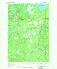
 1968 Muskallonge Lake SE1970 Print · USGSUpper Peninsula wilderness in the late sixties reveals a landscape shaped by water and woods within the Lake Superior State Forest. Researchers can trace old routes near Pine Stump Junction and the winding course of the Two Hearted River.
 - 1968 Map of Grand Marais SE, 1970 Print
 1968 Grand Marais SE1970 Print · USGSThe Upper Peninsula wilderness of the late sixties is mapped here along the shoreline of Lake Superior. Researchers can trace the winding paths of the North Branch Two Hearted River or locate remote landmarks like Dillingham Lake and Wheeler Lake.
 - 1968 Map of Grand Marais NE, 1970 Print
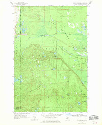
 1968 Grand Marais NE1970 Print · USGSThe Lake Superior shoreline in Luce County is captured here in the late sixties, showcasing a landscape of managed forests and winding waterways. Researchers can trace the network of a Truck Trail and Jeep Trail leading to the Blind Sucker Flooding and Lake Superior Campground.
 - 1968 Map of Betsy Lake NW, 1971 Print
 1968 Betsy Lake NW1971 Print · USGSUpper Peninsula wilderness along the Lake Superior shore comes into focus in the late sixties as the state forest system expands. Trace the winding Two Hearted River past the Landing Field and remote camps at Pike Lake and Two Hearted River Campground.2 unique versions available
 - 1968 Map of Betsy Lake SW, 1971 Print
 1968 Betsy Lake SW1971 Print · USGSUpper Peninsula wilderness in the late 1960s was a landscape of dense state forests and historic logging corridors. Researchers can trace the path of the Old Railroad Grade or explore the remote Little Two Hearted Lakes and Chesbrough Lake.2 unique versions available
 - 1968 Map of Betsy Lake South, 1971 Print
 1968 Betsy Lake South1971 Print · USGSUpper Peninsula timberlands and river systems define this Luce County landscape during the late sixties. Researchers can trace the path of the Tahquamenon River and locate historic infrastructure like the Old Railroad Grade and The Big Spring.
End of results
Showing maps 1-12 of 12
Frequently asked questions
- What are the different types of historical maps available for Luce County?
- What is the oldest map of Luce County?
- Where can I purchase historical maps of Luce County for my home or office?
- Where can I download high-res historical maps of Luce County?
- Are there historical topographic maps available for Luce County?
- Is there historical aerial imagery available for Luce County?
- Where are historical maps of Luce County sourced from?